Pedregoso elevation
Pedregoso (Zacatecas, Pinos), Mexico elevation is 2185 meters and Pedregoso elevation in feet is 7169 ft above sea level [src 1]. Pedregoso is a populated place (feature code) with elevation that is 871 meters (2858 ft) bigger than average city elevation in Mexico.
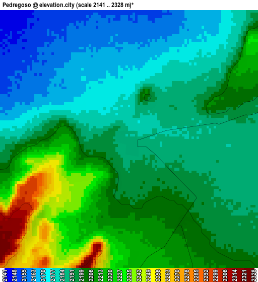
Below is the Elevation map of Pedregoso, which displays elevation range with different colors. Scale of the first map is from 2141 to 2328 m (7024 to 7638 ft) with average elevation of 2196.1 meters (=7205 ft) [note 1]
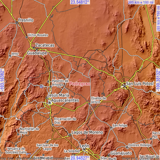
These maps also provides idea of topography and contour of this city, they are displayed at different zoom levels. More info about maps, scale and edge coordinates you can find below images.
| \ | Map #1 | Topo.Map |
| Scale [m] | 2141..2328 m | × |
| Scale [ft] | 7024..7638 ft | × |
| Average | 2196.1 m = 7205 ft | × |
| Width | 9.04 km = 5.6 mi | 289.4 km = 179.8 mi |
| Height | 9.04 km = 5.6 mi | 289.4 km = 179.8 mi |
| ↑Max Latitude | 22.293406° | 23.54812° |
| Latitude at center | 22.25274° | 22.25274° |
| ↓Min Latitude | 22.212062° | 20.94527° |
| ← Min Longitude | -101.801515° | -103.16382° |
| Longitude center | -101.75757° | -101.75757° |
| →Max Longitude | -101.713625° | -100.35132° |
Nearby cities:
Cities around Pedregoso sort by population:
• Pinos elevation 2453 m
19.3 km,  75°
75°
• Villa Hidalgo 2165 m
12.5 km,  21°
21°
• La Victoria 2308 m
13.2 km,  87°
87°
• El Nigromante 2212 m
12 km,  156°
156°
• El Obraje 2205 m
19 km,  115°
115°
• Estancia de Guadalupe 2290 m
10.8 km,  73°
73°
• El Refugio 2119 m
13.1 km,  358°
358°
• Rancho Nuevo de Morelos (De Guadalupe) 2124 m
10.2 km,  343°
343°
• Santa María de los Ángeles 2124 m
11.6 km,  287°
287°
• Colonia San Francisco (San Francisco) 2133 m
8.6 km,  311°
311°
• Colonia José María Morelos 2128 m
13.4 km, 343°
• Ignacio Zaragoza 2146 m
11.7 km,  323°
323°
Multilingual:
 En español:
Pedregoso elevación 2185 m.
 En France:
Pedregoso élévation 2185 m.
 Auf Deutsch:
Pedregoso höhe über dem Meeresspiegel ist 2185 m.

Sources and notes:
- [note 1] Map square and city borders are not equal. Map elevation data is calculated only from area inside that square.
- [src 1] Elevation data from geonames database provided with same terms of usage.
- [src 2] The elevation map of Pedregoso is generated using elevation data from NASA's 3 arcsec (90m) resolution SRTM data.
- [src 3] Base (background) map © OpenStreetMap contributors tiles are generated by Geofabrik and OpenTopoMap.
Copyright & License:
This Pedregoso Elevation Map is licensed under CC BY-SA. You may reuse any part from this page, if you give a proper credit by linking to this URL:
 More info on terms of use page.