Rosario elevation
Rosario (Sonora), Mexico elevation is 423 meters and Rosario elevation in feet is 1388 ft above sea level [src 1]. Rosario is a populated place (feature code) with elevation that is 891 meters (2923 ft) smaller than average city elevation in Mexico.
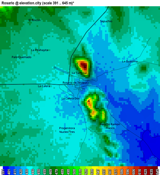
Below is the Elevation map of Rosario, which displays elevation range with different colors. Scale of the first map is from 391 to 645 m (1283 to 2116 ft) with average elevation of 441.5 meters (=1448 ft) [note 1]
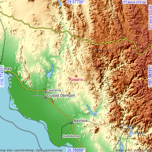
These maps also provides idea of topography and contour of this city, they are displayed at different zoom levels. More info about maps, scale and edge coordinates you can find below images.
| \ | Map #1 | Topo.Map |
| Scale [m] | 391..645 m | × |
| Scale [ft] | 1283..2116 ft | × |
| Average | 441.5 m = 1448 ft | × |
| Width | 8.64 km = 5.4 mi | 276.5 km = 171.8 mi |
| Height | 8.64 km = 5.4 mi | 276.5 km = 171.8 mi |
| ↑Max Latitude | 27.879962° | 29.07739° |
| Latitude at center | 27.84111° | 27.84111° |
| ↓Min Latitude | 27.802245° | 26.59058° |
| ← Min Longitude | -109.412005° | -110.77431° |
| Longitude center | -109.36806° | -109.36806° |
| →Max Longitude | -109.324115° | -107.96181° |
Nearby cities:
Cities around Rosario sort by population:
• Ciudad Obregón elevation 38 m
68.8 km,  235°
235°
• Esperanza 38 m
62.5 km, 242°
• Cocorit 35 m
65.3 km, 243°
• Providencia 28 m
71.4 km, 239°
• Antonio Rosales 53 m
72.5 km,  221°
221°
• Estación Corral 35 m
63.4 km,  248°
248°
• Vicente Guerrero 31 m
68.8 km, 240°
• Loma de Guamúchil 42 m
66.1 km, 247°
• San Bernardo 210 m
71.3 km,  133°
133°
• Quiriego 202 m
37.5 km,  162°
162°
• Tierra Blanca 52 m
72.7 km,  178°
178°
• Onavas 175 m
70.7 km,  347°
347°
Multilingual:
 En español:
Rosario elevación 423 m.
 En France:
Rosario élévation 423 m.


Sources and notes:
- [note 1] Map square and city borders are not equal. Map elevation data is calculated only from area inside that square.
- [src 1] Elevation data from geonames database provided with same terms of usage.
- [src 2] The elevation map of Rosario is generated using elevation data from NASA's 3 arcsec (90m) resolution SRTM data.
- [src 3] Base (background) map © OpenStreetMap contributors tiles are generated by Geofabrik and OpenTopoMap.
Copyright & License:
This Rosario Elevation Map is licensed under CC BY-SA. You may reuse any part from this page, if you give a proper credit by linking to this URL:
 More info on terms of use page.