Vito elevation
Vito (Hidalgo, Atotonilco de Tula), Mexico elevation is 2178 meters and Vito elevation in feet is 7146 ft above sea level [src 1]. Vito is a section of populated place (feature code) with elevation that is 864 meters (2835 ft) bigger than average city elevation in Mexico.
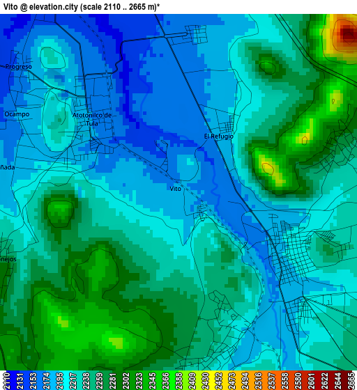
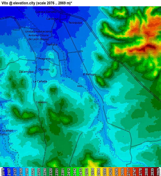
Below is the Elevation map of Vito, which displays elevation range with different colors. Scale of the first map is from 2110 to 2665 m (6923 to 8743 ft) with average elevation of 2229.2 meters (=7314 ft) [note 1]
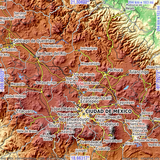
These maps also provides idea of topography and contour of this city, they are displayed at different zoom levels. More info about maps, scale and edge coordinates you can find below images.
| \ | Map #1 | Map #2 | Topo.Map |
| Scale [m] | 2110..2665 m | 2076..2869 m | × |
| Scale [ft] | 6923..8743 ft | 6811..9413 ft | × |
| Average | 2229.2 m = 7314 ft | 2257.1 m = 7405 ft | × |
| Width | 9.18 km = 5.7 mi | 18.37 km = 11.4 mi | 293.9 km = 182.6 mi |
| Height | 9.18 km = 5.7 mi | 18.37 km = 11.4 mi | 293.9 km = 182.6 mi |
| ↑Max Latitude | 20.031432° | 20.072714° | 21.30602° |
| Latitude at center | 19.99014° | 19.99014° | 19.99014° |
| ↓Min Latitude | 19.948837° | 19.907523° | 18.66317° |
| ← Min Longitude | -99.242925° | -99.286871° | -100.60523° |
| Longitude center | -99.19898° | -99.19898° | -99.19898° |
| →Max Longitude | -99.155035° | -99.111089° | -97.79273° |
Nearby cities:
Cities around Vito sort by population:
• Apaxco de Ocampo elevation 2201 m
3.4 km,  119°
119°
• Atotonilco de Tula 2163 m
2.8 km,  314°
314°
• Conejos 2259 m
4.9 km,  250°
250°
• Santa María Apaxco 2212 m
4.1 km,  161°
161°
• Tlamaco (San Gerónimo Tlamaco) 2134 m
5.9 km,  327°
327°
• Coyotillos 2255 m
4.4 km,  75°
75°
• Progreso 2160 m
5.3 km, 308°
• El Refugio 2189 m
2 km,  34°
34°
• Cañada 2183 m
4.3 km,  281°
281°
• Colonia Juárez 2254 m
5.2 km, 83°
• Colonia 3 de Mayo (La Cruz) 2222 m
3.8 km,  105°
105°
• Ocampo 2176 m
4.7 km,  296°
296°
Multilingual:
 En español:
Vito elevación 2178 m.
 En France:
Vito élévation 2178 m.


Sources and notes:
- [note 1] Map square and city borders are not equal. Map elevation data is calculated only from area inside that square.
- [src 1] Elevation data from geonames database provided with same terms of usage.
- [src 2] The elevation map of Vito is generated using elevation data from NASA's 3 arcsec (90m) resolution SRTM data.
- [src 3] Base (background) map © OpenStreetMap contributors tiles are generated by Geofabrik and OpenTopoMap.
Copyright & License:
This Vito Elevation Map is licensed under CC BY-SA. You may reuse any part from this page, if you give a proper credit by linking to this URL:
 More info on terms of use page.