San Bartolomé Coatepec elevation
San Bartolomé Coatepec (State of Mexico, Huixquilucan), Mexico elevation is 2473 meters and San Bartolomé Coatepec elevation in feet is 8114 ft above sea level [src 1]. San Bartolomé Coatepec is a populated place (feature code) with elevation that is 1159 meters (3802 ft) bigger than average city elevation in Mexico.
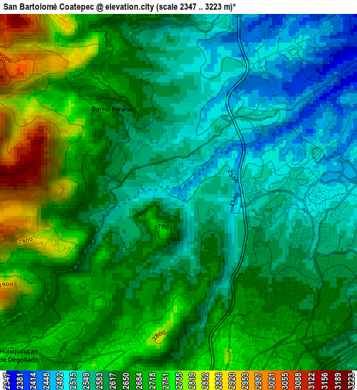
Below is the Elevation map of San Bartolomé Coatepec, which displays elevation range with different colors. Scale of the first map is from 2347 to 3223 m (7700 to 10574 ft) with average elevation of 2637.1 meters (=8652 ft) [note 1]
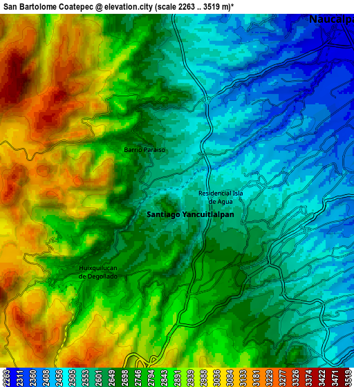
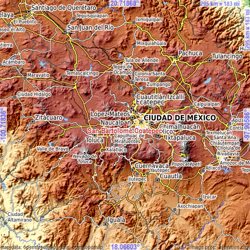
These maps also provides idea of topography and contour of this city, they are displayed at different zoom levels. More info about maps, scale and edge coordinates you can find below images.
| \ | Map #1 | Map #2 | Topo.Map |
| Scale [m] | 2347..3223 m | 2263..3519 m | × |
| Scale [ft] | 7700..10574 ft | 7425..11545 ft | × |
| Average | 2637.1 m = 8652 ft | 2729.5 m = 8955 ft | × |
| Width | 9.22 km = 5.7 mi | 18.44 km = 11.5 mi | 294.9 km = 183.2 mi |
| Height | 9.22 km = 5.7 mi | 18.44 km = 11.5 mi | 295 km = 183.3 mi |
| ↑Max Latitude | 19.439206° | 19.48064° | 20.71868° |
| Latitude at center | 19.39776° | 19.39776° | 19.39776° |
| ↓Min Latitude | 19.356304° | 19.314837° | 18.06603° |
| ← Min Longitude | -99.356055° | -99.400001° | -100.71836° |
| Longitude center | -99.31211° | -99.31211° | -99.31211° |
| →Max Longitude | -99.268165° | -99.224219° | -97.90586° |
Nearby cities:
Cities around San Bartolomé Coatepec sort by population:
• Delegación Cuajimalpa de Morelos elevation 2655 m
3.9 km,  144°
144°
• Jesús del Monte 2653 m
3.1 km, 143°
• La Magdalena Chichicaspa 2592 m
2.2 km,  319°
319°
• Santiago Yancuitlalpan 2631 m
1.7 km,  153°
153°
• Dos Ríos 2644 m
4.2 km,  232°
232°
• Paraje el Mirador 2586 m
1.6 km,  276°
276°
• San Jacinto 2756 m
4 km,  196°
196°
• Paraje la Pera 2700 m
3.9 km,  240°
240°
• Ejido el Castillo 2548 m
4.3 km,  8°
8°
• Paraje Trejo (El Chaparral) 2556 m
0.9 km,  359°
359°
• Llano de las Flores (Barrio del Hueso) 2615 m
4.4 km,  345°
345°
• Barrio de San Ramón 2711 m
3.3 km,  216°
216°
Multilingual:
 En español:
San Bartolomé Coatepec elevación 2473 m.
 En France:
San Bartolomé Coatepec élévation 2473 m.
 Auf Deutsch:
San Bartolomé Coatepec höhe über dem Meeresspiegel ist 2473 m.
 На русском:
San Bartolomé Coatepec высота над уровнем моря 2473 м
Sources and notes:
- [note 1] Map square and city borders are not equal. Map elevation data is calculated only from area inside that square.
- [src 1] Elevation data from geonames database provided with same terms of usage.
- [src 2] The elevation map of San Bartolomé Coatepec is generated using elevation data from NASA's 3 arcsec (90m) resolution SRTM data.
- [src 3] Base (background) map © OpenStreetMap contributors tiles are generated by Geofabrik and OpenTopoMap.
Copyright & License:
This San Bartolomé Coatepec Elevation Map is licensed under CC BY-SA. You may reuse any part from this page, if you give a proper credit by linking to this URL:
 More info on terms of use page.