San Pedro Totoltepec elevation
San Pedro Totoltepec (Morelos), Mexico elevation is 2588 meters and San Pedro Totoltepec elevation in feet is 8491 ft above sea level [src 1]. San Pedro Totoltepec is a populated place (feature code) with elevation that is 1274 meters (4180 ft) bigger than average city elevation in Mexico.
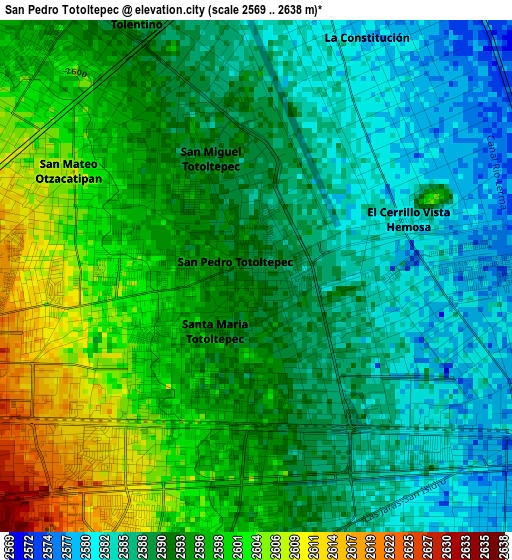
Below is the Elevation map of San Pedro Totoltepec, which displays elevation range with different colors. Scale of the first map is from 2569 to 2638 m (8428 to 8655 ft) with average elevation of 2592.4 meters (=8505 ft) [note 1]
These maps also provides idea of topography and contour of this city, they are displayed at different zoom levels. More info about maps, scale and edge coordinates you can find below images.
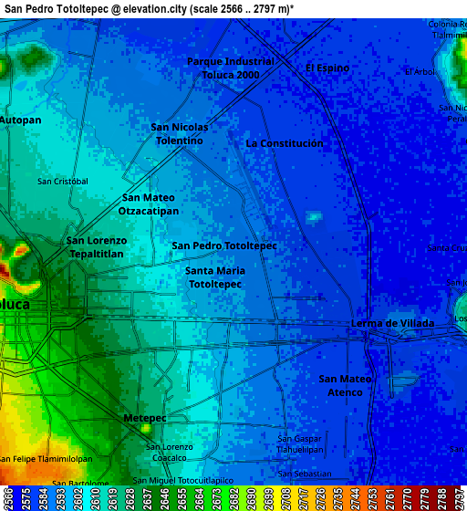
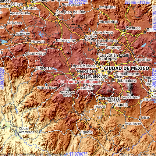
| \ | Map #1 | Map #2 | Topo.Map |
| Scale [m] | 2569..2638 m | 2566..2797 m | × |
| Scale [ft] | 8428..8655 ft | 8419..9177 ft | × |
| Average | 2592.4 m = 8505 ft | 2599.5 m = 8529 ft | × |
| Width | 9.22 km = 5.7 mi | 18.45 km = 11.5 mi | 295.1 km = 183.4 mi |
| Height | 9.22 km = 5.7 mi | 18.45 km = 11.5 mi | 295.1 km = 183.4 mi |
| ↑Max Latitude | 19.352548° | 19.394005° | 20.63272° |
| Latitude at center | 19.31108° | 19.31108° | 19.31108° |
| ↓Min Latitude | 19.269602° | 19.228113° | 17.97867° |
| ← Min Longitude | -99.615915° | -99.659861° | -100.97822° |
| Longitude center | -99.57197° | -99.57197° | -99.57197° |
| →Max Longitude | -99.528025° | -99.484079° | -98.16572° |
Nearby cities:
Cities around San Pedro Totoltepec sort by population:
• San José Guadalupe Otzacatipan elevation 2591 m
4.3 km,  330°
330°
• San Jerónimo Chicahualco 2606 m
3.8 km,  214°
214°
• San Mateo Otzacatipan 2603 m
4.1 km,  306°
306°
• Santa María Totoltepec 2601 m
2.2 km,  256°
256°
• El Cerrillo Vista Hermosa 2603 m
3.4 km,  66°
66°
• San Nicolás Tolentino 2583 m
5.3 km,  0°
0°
• La Constitución Toltepec 2580 m
4.8 km,  29°
29°
• San Miguel Totoltepec 2591 m
1.6 km,  337°
337°
• Arroyo Vista Hermosa 2577 m
4.3 km,  59°
59°
• Colonia los Cedros 2578 m
3.2 km,  88°
88°
• Guadalupe Totoltepec 2583 m
4.2 km,  11°
11°
• Colonia Isidro Fabela 2575 m
5.3 km,  102°
102°
Multilingual:
 En español:
San Pedro Totoltepec elevación 2588 m.
 En France:
San Pedro Totoltepec élévation 2588 m.
 Auf Deutsch:
San Pedro Totoltepec höhe über dem Meeresspiegel ist 2588 m.
 На русском:
San Pedro Totoltepec высота над уровнем моря 2588 м
Sources and notes:
- [note 1] Map square and city borders are not equal. Map elevation data is calculated only from area inside that square.
- [src 1] Elevation data from geonames database provided with same terms of usage.
- [src 2] The elevation map of San Pedro Totoltepec is generated using elevation data from NASA's 3 arcsec (90m) resolution SRTM data.
- [src 3] Base (background) map © OpenStreetMap contributors tiles are generated by Geofabrik and OpenTopoMap.
Copyright & License:
This San Pedro Totoltepec Elevation Map is licensed under CC BY-SA. You may reuse any part from this page, if you give a proper credit by linking to this URL:
 More info on terms of use page.