San Pedro Abajo elevation
San Pedro Abajo (State of Mexico, Temoaya), Mexico elevation is 2807 meters and San Pedro Abajo elevation in feet is 9209 ft above sea level [src 1]. San Pedro Abajo is a populated place (feature code) with elevation that is 1493 meters (4898 ft) bigger than average city elevation in Mexico.
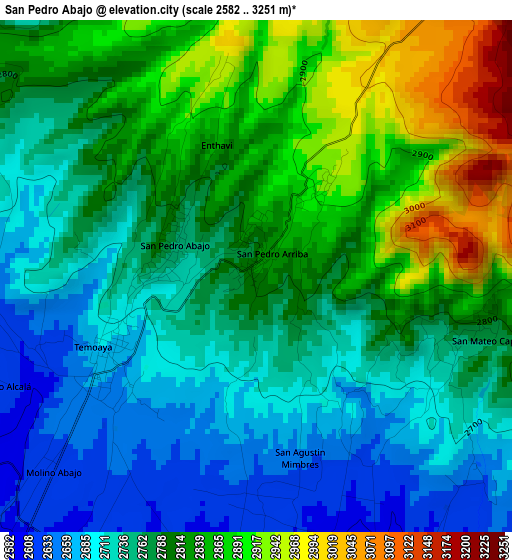
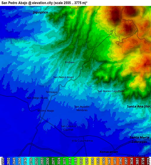
Below is the Elevation map of San Pedro Abajo, which displays elevation range with different colors. Scale of the first map is from 2582 to 3251 m (8471 to 10666 ft) with average elevation of 2786 meters (=9140 ft) [note 1]
These maps also provides idea of topography and contour of this city, they are displayed at different zoom levels. More info about maps, scale and edge coordinates you can find below images.
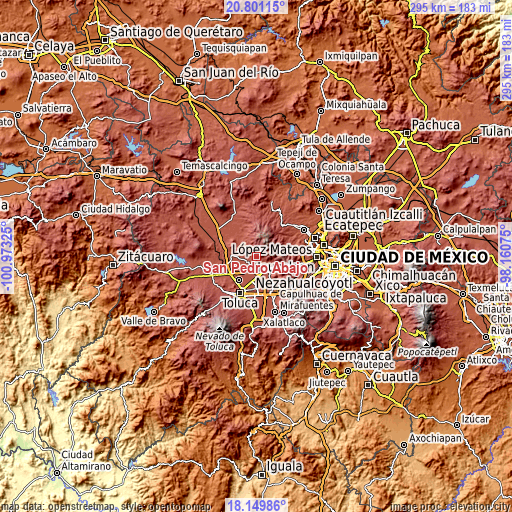
| \ | Map #1 | Map #2 | Topo.Map |
| Scale [m] | 2582..3251 m | 2555..3775 m | × |
| Scale [ft] | 8471..10666 ft | 8383..12385 ft | × |
| Average | 2786 m = 9140 ft | 2825.2 m = 9269 ft | × |
| Width | 9.21 km = 5.7 mi | 18.43 km = 11.5 mi | 294.8 km = 183.2 mi |
| Height | 9.21 km = 5.7 mi | 18.43 km = 11.5 mi | 294.8 km = 183.2 mi |
| ↑Max Latitude | 19.522354° | 19.563768° | 20.80115° |
| Latitude at center | 19.48093° | 19.48093° | 19.48093° |
| ↓Min Latitude | 19.439495° | 19.39805° | 18.14986° |
| ← Min Longitude | -99.610945° | -99.654891° | -100.97325° |
| Longitude center | -99.567° | -99.567° | -99.567° |
| →Max Longitude | -99.523055° | -99.479109° | -98.16075° |
Nearby cities:
Cities around San Pedro Abajo sort by population:
• San Pedro Arriba elevation 2850 m
0.8 km,  37°
37°
• Enthavi 2803 m
2.1 km,  336°
336°
• San Agustín Mimbres 2630 m
3.5 km,  161°
161°
• Temoaya 2671 m
3.2 km,  242°
242°
• San Mateo Capulhuac 2777 m
4.4 km,  105°
105°
• San Pedro Arriba 3ra. Sección 2934 m
2.4 km,  24°
24°
• Solalpan 1ra. Sección 2835 m
1.5 km,  329°
329°
• Pothé 2649 m
3.9 km,  258°
258°
• La Cañada 2772 m
3.4 km,  280°
280°
• Tierra Blanca 2880 m
3.4 km, 328°
• La Magdalena Tenexpan 2681 m
3 km,  229°
229°
• Tlaltenanguito 2847 m
2.6 km,  318°
318°
Multilingual:
 En español:
San Pedro Abajo, San Pedro de Abajo elevación 2807 m.
 En France:
San Pedro Abajo élévation 2807 m.
 Auf Deutsch:
San Pedro Abajo höhe über dem Meeresspiegel ist 2807 m.

Sources and notes:
- [note 1] Map square and city borders are not equal. Map elevation data is calculated only from area inside that square.
- [src 1] Elevation data from geonames database provided with same terms of usage.
- [src 2] The elevation map of San Pedro Abajo is generated using elevation data from NASA's 3 arcsec (90m) resolution SRTM data.
- [src 3] Base (background) map © OpenStreetMap contributors tiles are generated by Geofabrik and OpenTopoMap.
Copyright & License:
This San Pedro Abajo Elevation Map is licensed under CC BY-SA. You may reuse any part from this page, if you give a proper credit by linking to this URL:
 More info on terms of use page.