Fresno Nichi elevation
Fresno Nichi (State of Mexico, San Felipe del Progreso), Mexico elevation is 2901 meters and Fresno Nichi elevation in feet is 9518 ft above sea level [src 1]. Fresno Nichi is a populated place (feature code) with elevation that is 1587 meters (5207 ft) bigger than average city elevation in Mexico.
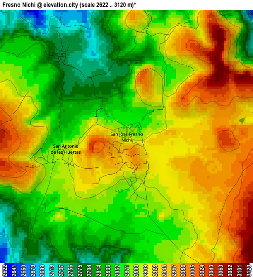
Below is the Elevation map of Fresno Nichi, which displays elevation range with different colors. Scale of the first map is from 2622 to 3120 m (8602 to 10236 ft) with average elevation of 2888.9 meters (=9478 ft) [note 1]
These maps also provides idea of topography and contour of this city, they are displayed at different zoom levels. More info about maps, scale and edge coordinates you can find below images.
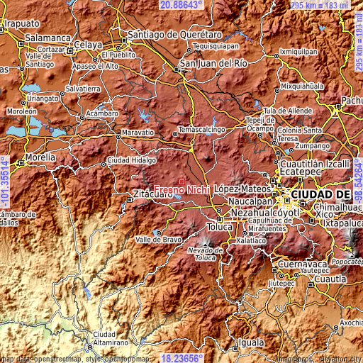
| \ | Map #1 | Topo.Map |
| Scale [m] | 2622..3120 m | × |
| Scale [ft] | 8602..10236 ft | × |
| Average | 2888.9 m = 9478 ft | × |
| Width | 9.21 km = 5.7 mi | 294.6 km = 183.1 mi |
| Height | 9.21 km = 5.7 mi | 294.7 km = 183.1 mi |
| ↑Max Latitude | 19.608342° | 20.88643° |
| Latitude at center | 19.56694° | 19.56694° |
| ↓Min Latitude | 19.525527° | 18.23656° |
| ← Min Longitude | -99.992835° | -101.35514° |
| Longitude center | -99.94889° | -99.94889° |
| →Max Longitude | -99.904945° | -98.54264° |
Nearby cities:
Cities around Fresno Nichi sort by population:
• San Antonio de las Huertas elevation 2900 m
2.4 km,  257°
257°
• Barrio de Centro del Cerrillo 2842 m
3.4 km,  189°
189°
• Palos Amarillos (Palos Amarillos Yebuciví) 2977 m
4.6 km,  132°
132°
• La Campanilla 2957 m
6.4 km,  173°
173°
• Mina Vieja 2902 m
1.7 km,  161°
161°
• Guadalupe Coté 2636 m
6.2 km,  322°
322°
• San Juan Cote Ejido 2765 m
4.4 km,  345°
345°
• Santa Ana Nichi Ejido 2898 m
4.6 km,  294°
294°
• Barrio de San Isidro 2762 m
5.2 km, 191°
• La Guadalupana 3005 m
4.4 km,  108°
108°
• Barrio de San Miguel 2737 m
6.1 km, 185°
• Barrio de Puentecillas 2766 m
5.1 km,  227°
227°
Multilingual:
 En español:
Fresno Nichi elevación 2901 m.
 En France:
Fresno Nichi élévation 2901 m.
 Auf Deutsch:
Fresno Nichi höhe über dem Meeresspiegel ist 2901 m.

Sources and notes:
- [note 1] Map square and city borders are not equal. Map elevation data is calculated only from area inside that square.
- [src 1] Elevation data from geonames database provided with same terms of usage.
- [src 2] The elevation map of Fresno Nichi is generated using elevation data from NASA's 3 arcsec (90m) resolution SRTM data.
- [src 3] Base (background) map © OpenStreetMap contributors tiles are generated by Geofabrik and OpenTopoMap.
Copyright & License:
This Fresno Nichi Elevation Map is licensed under CC BY-SA. You may reuse any part from this page, if you give a proper credit by linking to this URL:
 More info on terms of use page.