Guadalupe Cachi elevation
Guadalupe Cachi (State of Mexico, Ixtlahuaca), Mexico elevation is 2540 meters and Guadalupe Cachi elevation in feet is 8333 ft above sea level [src 1]. Guadalupe Cachi is a populated place (feature code) with elevation that is 1226 meters (4022 ft) bigger than average city elevation in Mexico.
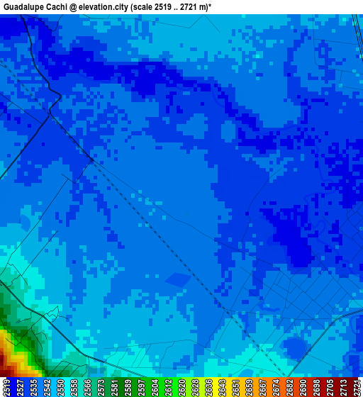
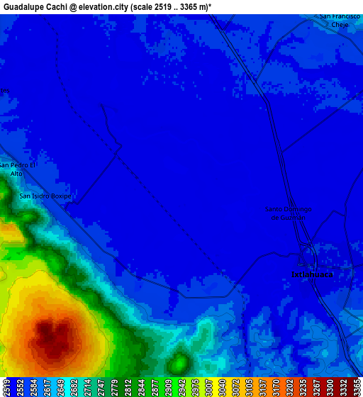
Below is the Elevation map of Guadalupe Cachi, which displays elevation range with different colors. Scale of the first map is from 2519 to 2721 m (8264 to 8927 ft) with average elevation of 2539.4 meters (=8331 ft) [note 1]
These maps also provides idea of topography and contour of this city, they are displayed at different zoom levels. More info about maps, scale and edge coordinates you can find below images.
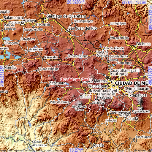
| \ | Map #1 | Map #2 | Topo.Map |
| Scale [m] | 2519..2721 m | 2519..3365 m | × |
| Scale [ft] | 8264..8927 ft | 8264..11040 ft | × |
| Average | 2539.4 m = 8331 ft | 2615 m = 8579 ft | × |
| Width | 9.21 km = 5.7 mi | 18.41 km = 11.4 mi | 294.6 km = 183.1 mi |
| Height | 9.21 km = 5.7 mi | 18.41 km = 11.4 mi | 294.6 km = 183.1 mi |
| ↑Max Latitude | 19.642503° | 19.683886° | 20.92031° |
| Latitude at center | 19.60111° | 19.60111° | 19.60111° |
| ↓Min Latitude | 19.559706° | 19.518291° | 18.271° |
| ← Min Longitude | -99.868945° | -99.912891° | -101.23125° |
| Longitude center | -99.825° | -99.825° | -99.825° |
| →Max Longitude | -99.781055° | -99.737109° | -98.41875° |
Nearby cities:
Cities around Guadalupe Cachi sort by population:
• San Pedro Los Baños elevation 2527 m
2.7 km,  7°
7°
• Santo Domingo de Guzmán 2536 m
4.8 km,  100°
100°
• Emiliano Zapata (Santo Domingo) 2539 m
4.5 km,  121°
121°
• San Ildefonso 2539 m
6.1 km,  137°
137°
• San Juan de las Manzanas 2569 m
5.7 km,  194°
194°
• Santa Ana la Ladera 2542 m
4.8 km,  262°
262°
• San Miguel Enyege 2562 m
5 km,  226°
226°
• San Mateo Ixtlahuaca 2536 m
2.6 km,  76°
76°
• La Concepción Enyege 2552 m
4.4 km,  202°
202°
• San Andrés del Pedregal 2567 m
5.1 km,  243°
243°
• San Francisco de Guzmán 2537 m
5.7 km,  67°
67°
• San Pablo de los Remedios 2544 m
4.7 km,  342°
342°
Multilingual:
 En español:
Guadalupe Cachi elevación 2540 m.
 En France:
Guadalupe Cachi élévation 2540 m.
 Auf Deutsch:
Guadalupe Cachi höhe über dem Meeresspiegel ist 2540 m.

Sources and notes:
- [note 1] Map square and city borders are not equal. Map elevation data is calculated only from area inside that square.
- [src 1] Elevation data from geonames database provided with same terms of usage.
- [src 2] The elevation map of Guadalupe Cachi is generated using elevation data from NASA's 3 arcsec (90m) resolution SRTM data.
- [src 3] Base (background) map © OpenStreetMap contributors tiles are generated by Geofabrik and OpenTopoMap.
Copyright & License:
This Guadalupe Cachi Elevation Map is licensed under CC BY-SA. You may reuse any part from this page, if you give a proper credit by linking to this URL:
 More info on terms of use page.