Las Peñas elevation
Las Peñas (State of Mexico, Villa Victoria), Mexico elevation is 2594 meters and Las Peñas elevation in feet is 8510 ft above sea level [src 1]. Las Peñas is a populated place (feature code) with elevation that is 1280 meters (4199 ft) bigger than average city elevation in Mexico.
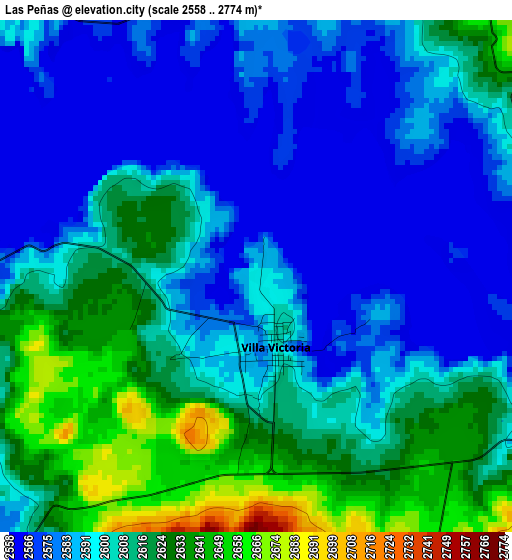
Below is the Elevation map of Las Peñas, which displays elevation range with different colors. Scale of the first map is from 2558 to 2774 m (8392 to 9101 ft) with average elevation of 2599.9 meters (=8530 ft) [note 1]
These maps also provides idea of topography and contour of this city, they are displayed at different zoom levels. More info about maps, scale and edge coordinates you can find below images.
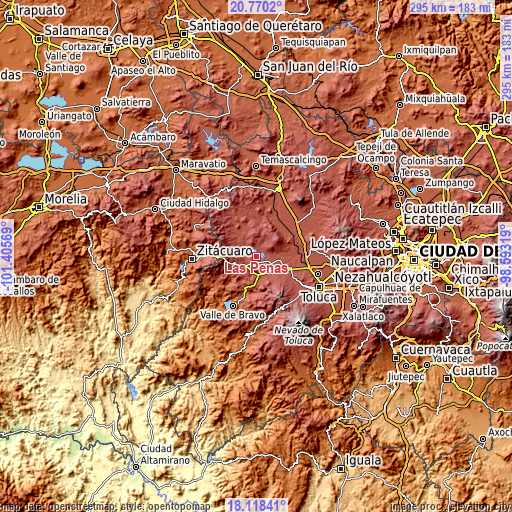
| \ | Map #1 | Topo.Map |
| Scale [m] | 2558..2774 m | × |
| Scale [ft] | 8392..9101 ft | × |
| Average | 2599.9 m = 8530 ft | × |
| Width | 9.21 km = 5.7 mi | 294.9 km = 183.2 mi |
| Height | 9.21 km = 5.7 mi | 294.9 km = 183.2 mi |
| ↑Max Latitude | 19.491152° | 20.7702° |
| Latitude at center | 19.44972° | 19.44972° |
| ↓Min Latitude | 19.408277° | 18.11841° |
| ← Min Longitude | -100.043385° | -101.40569° |
| Longitude center | -99.99944° | -99.99944° |
| →Max Longitude | -99.955495° | -98.59319° |
Nearby cities:
Cities around Las Peñas sort by population:
• Villa Victoria elevation 2600 m
1.5 km,  165°
165°
• San Marcos de la Loma 2721 m
7 km,  35°
35°
• La Puerta del Pilar 2629 m
2.1 km,  304°
304°
• San Diego del Cerrito 2659 m
6.5 km,  353°
353°
• El Espinal 2612 m
6.7 km,  287°
287°
• Jesús María 2653 m
3.6 km,  175°
175°
• Barrio el Vivero 2579 m
3.8 km,  275°
275°
• Venta de Ocotillos 2606 m
4.9 km,  60°
60°
• San Pedro del Rincón 2617 m
2.2 km,  222°
222°
• San Agustín Berros 2825 m
5.4 km,  192°
192°
• San Roque 2616 m
5.3 km,  50°
50°
• Cerritos del Pilar 2628 m
2.1 km,  255°
255°
Multilingual:
 En español:
Las Peñas elevación 2594 m.
 En France:
Las Peñas élévation 2594 m.
 Auf Deutsch:
Las Peñas höhe über dem Meeresspiegel ist 2594 m.

Sources and notes:
- [note 1] Map square and city borders are not equal. Map elevation data is calculated only from area inside that square.
- [src 1] Elevation data from geonames database provided with same terms of usage.
- [src 2] The elevation map of Las Peñas is generated using elevation data from NASA's 3 arcsec (90m) resolution SRTM data.
- [src 3] Base (background) map © OpenStreetMap contributors tiles are generated by Geofabrik and OpenTopoMap.
Copyright & License:
This Las Peñas Elevation Map is licensed under CC BY-SA. You may reuse any part from this page, if you give a proper credit by linking to this URL:
 More info on terms of use page.