Ocelota elevation
Ocelota (Veracruz, San Andrés Tuxtla), Mexico elevation is 118 meters and Ocelota elevation in feet is 387 ft above sea level [src 1]. Ocelota is a populated place (feature code) with elevation that is 1196 meters (3924 ft) smaller than average city elevation in Mexico.
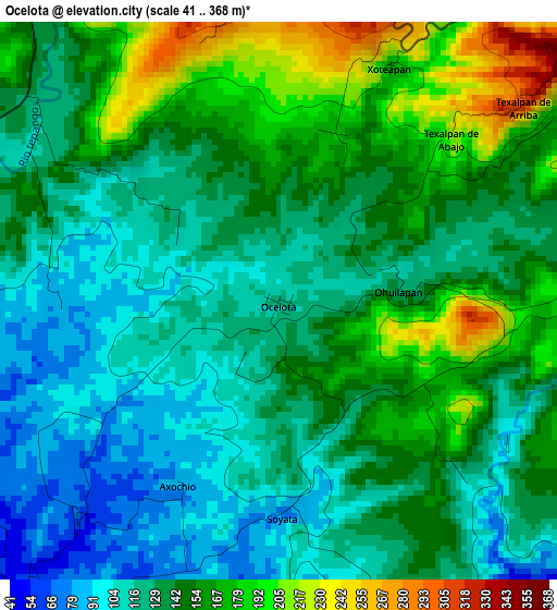
Below is the Elevation map of Ocelota, which displays elevation range with different colors. Scale of the first map is from 41 to 368 m (135 to 1207 ft) with average elevation of 140.9 meters (=462 ft) [note 1]
These maps also provides idea of topography and contour of this city, they are displayed at different zoom levels. More info about maps, scale and edge coordinates you can find below images.
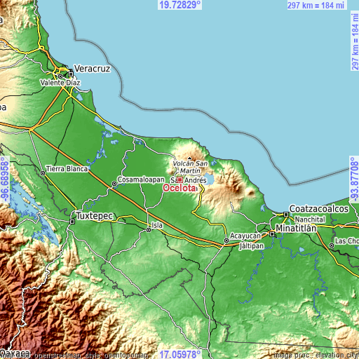
| \ | Map #1 | Topo.Map |
| Scale [m] | 41..368 m | × |
| Scale [ft] | 135..1207 ft | × |
| Average | 140.9 m = 462 ft | × |
| Width | 9.27 km = 5.8 mi | 296.7 km = 184.4 mi |
| Height | 9.27 km = 5.8 mi | 296.7 km = 184.4 mi |
| ↑Max Latitude | 18.440894° | 19.72829° |
| Latitude at center | 18.3992° | 18.3992° |
| ↓Min Latitude | 18.357496° | 17.05978° |
| ← Min Longitude | -95.327275° | -96.68958° |
| Longitude center | -95.28333° | -95.28333° |
| →Max Longitude | -95.239385° | -93.87708° |
Nearby cities:
Cities around Ocelota sort by population:
• Santiago Tuxtla elevation 201 m
7.6 km,  346°
346°
• Texcaltitán Xoteapan (Texcaltitán) 219 m
6.2 km,  30°
30°
• Texalpan de Arriba 319 m
5.3 km,  50°
50°
• Xoteapan 189 m
4.3 km,  24°
24°
• Texalpan de Abajo 259 m
4.3 km,  42°
42°
• Tilapan 48 m
7.3 km,  220°
220°
• Juan Jacobo Torres [Bodega de Totontepec] 40 m
7.4 km,  160°
160°
• Axochío 84 m
3.5 km,  209°
209°
• Ohuilapam 121 m
2.2 km,  81°
81°
• Los Pinos 217 m
6.5 km, 40°
• Cuesta Amarilla 129 m
7.8 km,  138°
138°
• Soyata 86 m
3.4 km,  178°
178°
Multilingual:
 En español:
Ocelota elevación 118 m.
 En France:
Ocelota élévation 118 m.


Sources and notes:
- [note 1] Map square and city borders are not equal. Map elevation data is calculated only from area inside that square.
- [src 1] Elevation data from geonames database provided with same terms of usage.
- [src 2] The elevation map of Ocelota is generated using elevation data from NASA's 3 arcsec (90m) resolution SRTM data.
- [src 3] Base (background) map © OpenStreetMap contributors tiles are generated by Geofabrik and OpenTopoMap.
Copyright & License:
This Ocelota Elevation Map is licensed under CC BY-SA. You may reuse any part from this page, if you give a proper credit by linking to this URL:
 More info on terms of use page.