Peñuela elevation
Peñuela (Veracruz, Amatlán de los Reyes), Mexico elevation is 734 meters and Peñuela elevation in feet is 2408 ft above sea level [src 1]. Peñuela is a populated place (feature code) with elevation that is 580 meters (1903 ft) smaller than average city elevation in Mexico.
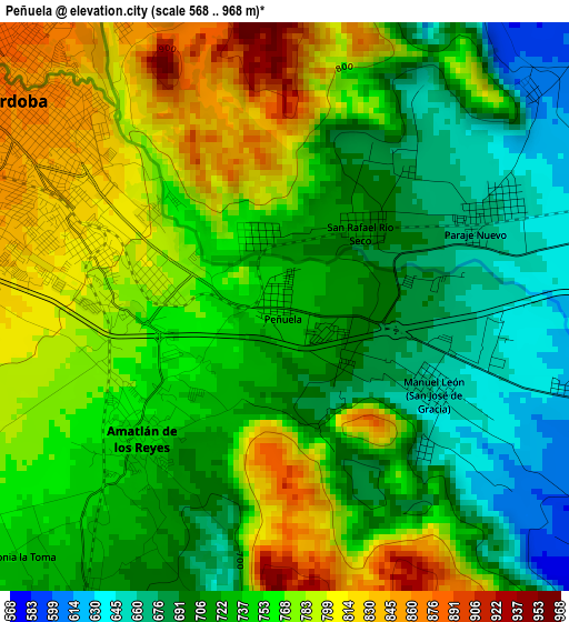
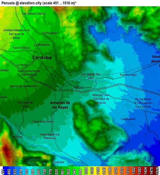
Below is the Elevation map of Peñuela, which displays elevation range with different colors. Scale of the first map is from 568 to 968 m (1864 to 3176 ft) with average elevation of 745.5 meters (=2446 ft) [note 1]
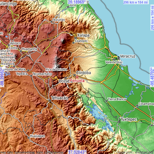
These maps also provides idea of topography and contour of this city, they are displayed at different zoom levels. More info about maps, scale and edge coordinates you can find below images.
| \ | Map #1 | Map #2 | Topo.Map |
| Scale [m] | 568..968 m | 451..1516 m | × |
| Scale [ft] | 1864..3176 ft | 1480..4974 ft | × |
| Average | 745.5 m = 2446 ft | 756.1 m = 2481 ft | × |
| Width | 9.25 km = 5.7 mi | 18.5 km = 11.5 mi | 295.9 km = 183.9 mi |
| Height | 9.25 km = 5.7 mi | 18.5 km = 11.5 mi | 295.9 km = 183.9 mi |
| ↑Max Latitude | 18.9059° | 18.947469° | 20.18965° |
| Latitude at center | 18.86432° | 18.86432° | 18.86432° |
| ↓Min Latitude | 18.82273° | 18.78113° | 17.52843° |
| ← Min Longitude | -96.937215° | -96.981161° | -98.29952° |
| Longitude center | -96.89327° | -96.89327° | -96.89327° |
| →Max Longitude | -96.849325° | -96.805379° | -95.48702° |
Nearby cities:
Cities around Peñuela sort by population:
• Córdoba elevation 836 m
4.1 km,  303°
303°
• Amatlán de los Reyes 751 m
3.1 km,  230°
230°
• Paraje Nuevo 661 m
3.8 km,  64°
64°
• Guadalupe 701 m
6.3 km,  211°
211°
• Manuel León 657 m
2.6 km,  117°
117°
• Potrero Viejo 611 m
5.4 km,  74°
74°
• San José de Tapia 808 m
6.7 km,  253°
253°
• Cacahuatal 577 m
6.6 km, 124°
• San Rafael Río Seco 705 m
1.8 km,  43°
43°
• Veinte de Noviembre 861 m
6.5 km,  270°
270°
• Trapiche Viejo 790 m
6 km, 246°
• Centro de Readaptación Social 769 m
5.7 km,  238°
238°
Multilingual:
 En español:
Peñuela elevación 734 m.
 En France:
Peñuela élévation 734 m.


Sources and notes:
- [note 1] Map square and city borders are not equal. Map elevation data is calculated only from area inside that square.
- [src 1] Elevation data from geonames database provided with same terms of usage.
- [src 2] The elevation map of Peñuela is generated using elevation data from NASA's 3 arcsec (90m) resolution SRTM data.
- [src 3] Base (background) map © OpenStreetMap contributors tiles are generated by Geofabrik and OpenTopoMap.
Copyright & License:
This Peñuela Elevation Map is licensed under CC BY-SA. You may reuse any part from this page, if you give a proper credit by linking to this URL:
 More info on terms of use page.