Tihosuco elevation
Tihosuco (Quintana Roo, Felipe Carrillo Puerto), Mexico elevation is 36 meters and Tihosuco elevation in feet is 118 ft above sea level [src 1]. Tihosuco is a populated place (feature code) with elevation that is 1278 meters (4193 ft) smaller than average city elevation in Mexico.
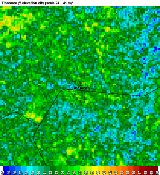
Below is the Elevation map of Tihosuco, which displays elevation range with different colors. Scale of the first map is from 24 to 41 m (79 to 135 ft) with average elevation of 32.1 meters (=105 ft) [note 1]
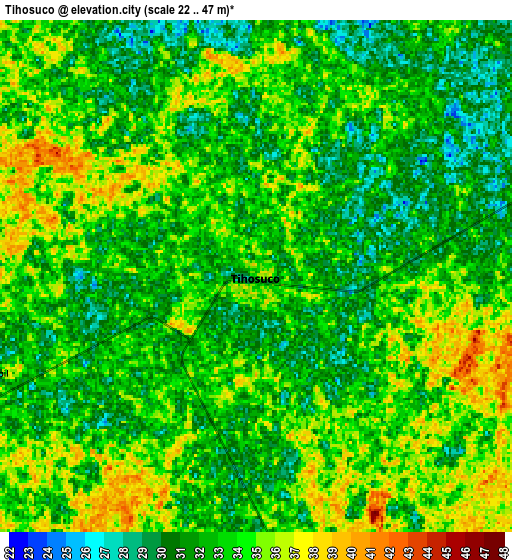
These maps also provides idea of topography and contour of this city, they are displayed at different zoom levels. More info about maps, scale and edge coordinates you can find below images.
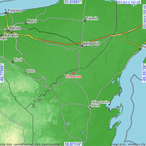
| \ | Map #1 | Map #2 | Topo.Map |
| Scale [m] | 24..41 m | 22..47 m | × |
| Scale [ft] | 79..135 ft | 72..154 ft | × |
| Average | 32.1 m = 105 ft | 32.8 m = 108 ft | × |
| Width | 9.17 km = 5.7 mi | 18.34 km = 11.4 mi | 293.5 km = 182.4 mi |
| Height | 9.17 km = 5.7 mi | 18.34 km = 11.4 mi | 293.5 km = 182.4 mi |
| ↑Max Latitude | 20.237658° | 20.278885° | 21.51051° |
| Latitude at center | 20.19642° | 20.19642° | 20.19642° |
| ↓Min Latitude | 20.155171° | 20.113912° | 18.87114° |
| ← Min Longitude | -88.417555° | -88.461501° | -89.77986° |
| Longitude center | -88.37361° | -88.37361° | -88.37361° |
| →Max Longitude | -88.329665° | -88.285719° | -86.96736° |
Nearby cities:
Cities around Tihosuco sort by population:
• Tixcacalcupul elevation 27 m
39.3 km,  15°
15°
• Señor 22 m
46.4 km,  147°
147°
• Tepich 27 m
13.2 km,  67°
67°
• Chikindzonot 30 m
19.3 km,  322°
322°
• Tekom 28 m
46.6 km,  14°
14°
• Saban 30 m
24.9 km,  223°
223°
• Tiholop 30 m
36.3 km,  294°
294°
• Huay Max 27 m
23.4 km, 222°
• Ekpedz 28 m
14.6 km,  335°
335°
• X Cabil 30 m
10 km,  249°
249°
• Santa Rosa Segundo 26 m
26.9 km, 154°
• Zacalaca 33 m
27.6 km,  237°
237°
Multilingual:
 En español:
Tihosuco elevación 36 m.
 En France:
Tihosuco élévation 36 m.


Sources and notes:
- [note 1] Map square and city borders are not equal. Map elevation data is calculated only from area inside that square.
- [src 1] Elevation data from geonames database provided with same terms of usage.
- [src 2] The elevation map of Tihosuco is generated using elevation data from NASA's 3 arcsec (90m) resolution SRTM data.
- [src 3] Base (background) map © OpenStreetMap contributors tiles are generated by Geofabrik and OpenTopoMap.
Copyright & License:
This Tihosuco Elevation Map is licensed under CC BY-SA. You may reuse any part from this page, if you give a proper credit by linking to this URL:
 More info on terms of use page.