El Salto elevation
El Salto (Guerrero, Acapulco de Juárez), Mexico elevation is 28 meters and El Salto elevation in feet is 92 ft above sea level [src 1]. El Salto is a populated place (feature code) with elevation that is 1286 meters (4219 ft) smaller than average city elevation in Mexico.
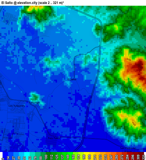
Below is the Elevation map of El Salto, which displays elevation range with different colors. Scale of the first map is from 2 to 321 m (7 to 1053 ft) with average elevation of 53.7 meters (=176 ft) [note 1]
These maps also provides idea of topography and contour of this city, they are displayed at different zoom levels. More info about maps, scale and edge coordinates you can find below images.
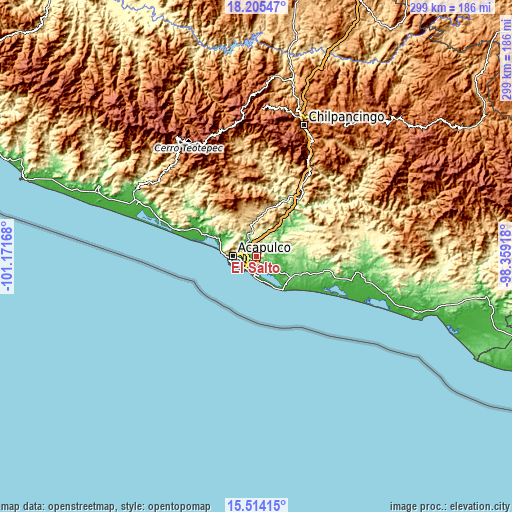
| \ | Map #1 | Topo.Map |
| Scale [m] | 2..321 m | × |
| Scale [ft] | 7..1053 ft | × |
| Average | 53.7 m = 176 ft | × |
| Width | 9.35 km = 5.8 mi | 299.2 km = 185.9 mi |
| Height | 9.35 km = 5.8 mi | 299.3 km = 186 mi |
| ↑Max Latitude | 16.906651° | 18.20547° |
| Latitude at center | 16.8646° | 16.8646° |
| ↓Min Latitude | 16.82254° | 15.51415° |
| ← Min Longitude | -99.809375° | -101.17168° |
| Longitude center | -99.76543° | -99.76543° |
| →Max Longitude | -99.721485° | -98.35918° |
Nearby cities:
Cities around El Salto sort by population:
• Tres Palos elevation 13 m
4.1 km,  199°
199°
• San Pedro las Playas 10 m
5.9 km,  142°
142°
• Tuncingo 54 m
3 km,  238°
238°
• San Isidro Gallinero (El Gallinero) 72 m
5.8 km,  71°
71°
• El Bejuco 23 m
7.6 km,  125°
125°
• Los Órganos de San Agustín 53 m
9.9 km,  321°
321°
• El Metlapil 13 m
3.1 km,  145°
145°
• Nueva Frontera 26 m
6 km,  295°
295°
• 10 de Abril 12 m
4.7 km, 146°
• Colonia Nueva Revolución 28 m
5.7 km,  311°
311°
• Colonia Alborada 26 m
5.9 km,  288°
288°
• Las Plazuelas 34 m
2.4 km, 296°
Multilingual:
 En español:
El Salto elevación 28 m.
 En France:
El Salto élévation 28 m.


Sources and notes:
- [note 1] Map square and city borders are not equal. Map elevation data is calculated only from area inside that square.
- [src 1] Elevation data from geonames database provided with same terms of usage.
- [src 2] The elevation map of El Salto is generated using elevation data from NASA's 3 arcsec (90m) resolution SRTM data.
- [src 3] Base (background) map © OpenStreetMap contributors tiles are generated by Geofabrik and OpenTopoMap.
Copyright & License:
This El Salto Elevation Map is licensed under CC BY-SA. You may reuse any part from this page, if you give a proper credit by linking to this URL:
 More info on terms of use page.