Venustiano Carranza elevation
Venustiano Carranza (Puebla), Mexico elevation is 132 meters and Venustiano Carranza elevation in feet is 433 ft above sea level [src 1]. Venustiano Carranza is a populated place (feature code) with elevation that is 1182 meters (3878 ft) smaller than average city elevation in Mexico.
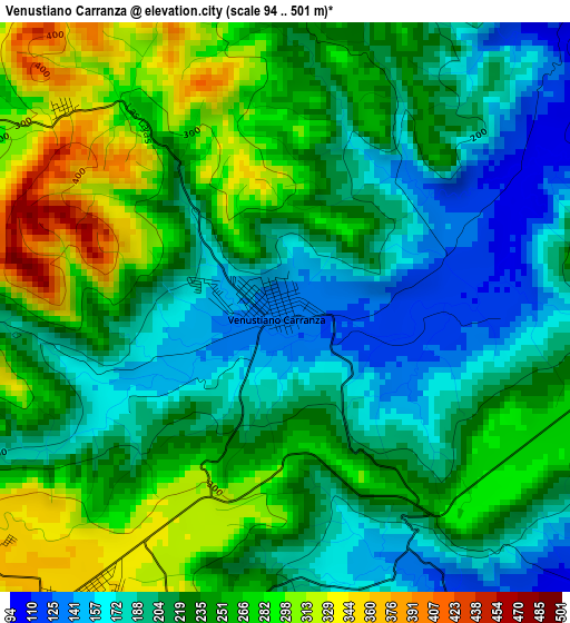
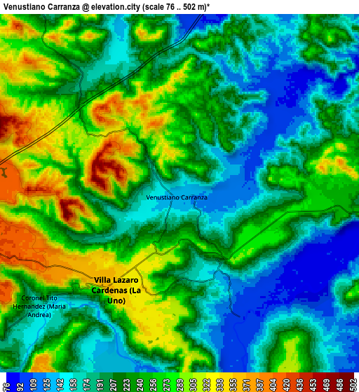
Below is the Elevation map of Venustiano Carranza, which displays elevation range with different colors. Scale of the first map is from 94 to 501 m (308 to 1644 ft) with average elevation of 230.5 meters (=756 ft) [note 1]
These maps also provides idea of topography and contour of this city, they are displayed at different zoom levels. More info about maps, scale and edge coordinates you can find below images.
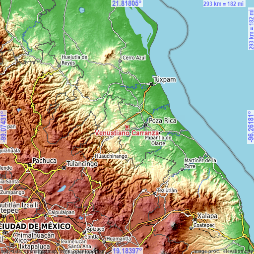
| \ | Map #1 | Map #2 | Topo.Map |
| Scale [m] | 94..501 m | 76..502 m | × |
| Scale [ft] | 308..1644 ft | 249..1647 ft | × |
| Average | 230.5 m = 756 ft | 224.7 m = 737 ft | × |
| Width | 9.15 km = 5.7 mi | 18.31 km = 11.4 mi | 292.9 km = 182 mi |
| Height | 9.15 km = 5.7 mi | 18.31 km = 11.4 mi | 292.9 km = 182 mi |
| ↑Max Latitude | 20.547825° | 20.588969° | 21.81805° |
| Latitude at center | 20.50667° | 20.50667° | 20.50667° |
| ↓Min Latitude | 20.465504° | 20.424327° | 19.18397° |
| ← Min Longitude | -97.712005° | -97.755951° | -99.07431° |
| Longitude center | -97.66806° | -97.66806° | -97.66806° |
| →Max Longitude | -97.624115° | -97.580169° | -96.26181° |
Nearby cities:
Cities around Venustiano Carranza sort by population:
• Villa Lázaro Cárdenas elevation 354 m
6 km,  213°
213°
• Zacate Colorado 69 m
15 km,  93°
93°
• Ricardo Flores Magón 60 m
18 km, 87°
• Coronel Tito Hernández 186 m
9 km,  231°
231°
• Emiliano Zapata 67 m
15.5 km,  72°
72°
• Calichar Palma Sola 103 m
14.2 km,  120°
120°
• La Colonia Guadalupe 149 m
18.7 km,  165°
165°
• Corralillos 80 m
15.1 km,  100°
100°
• Huitzilac 156 m
13.5 km,  325°
325°
• Ameluca 187 m
17.6 km,  291°
291°
• Miguel Hidalgo 67 m
18 km, 73°
• Chicualoque 143 m
13.8 km,  177°
177°
Multilingual:
 En español:
Venustiano Carranza elevación 132 m.
 En France:
Venustiano Carranza élévation 132 m.
 Auf Deutsch:
Venustiano Carranza höhe über dem Meeresspiegel ist 132 m.
 На русском:
Venustiano Carranza высота над уровнем моря 132 м
Sources and notes:
- [note 1] Map square and city borders are not equal. Map elevation data is calculated only from area inside that square.
- [src 1] Elevation data from geonames database provided with same terms of usage.
- [src 2] The elevation map of Venustiano Carranza is generated using elevation data from NASA's 3 arcsec (90m) resolution SRTM data.
- [src 3] Base (background) map © OpenStreetMap contributors tiles are generated by Geofabrik and OpenTopoMap.
Copyright & License:
This Venustiano Carranza Elevation Map is licensed under CC BY-SA. You may reuse any part from this page, if you give a proper credit by linking to this URL:
 More info on terms of use page.