Ganzda elevation
Ganzda (State of Mexico, Acambay de Ruíz Castañeda), Mexico elevation is 2801 meters and Ganzda elevation in feet is 9190 ft above sea level [src 1]. Ganzda is a populated place (feature code) with elevation that is 1487 meters (4879 ft) bigger than average city elevation in Mexico.
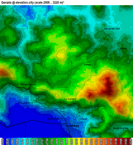
Below is the Elevation map of Ganzda, which displays elevation range with different colors. Scale of the first map is from 2508 to 3220 m (8228 to 10564 ft) with average elevation of 2734.5 meters (=8971 ft) [note 1]
These maps also provides idea of topography and contour of this city, they are displayed at different zoom levels. More info about maps, scale and edge coordinates you can find below images.
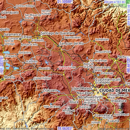
| \ | Map #1 | Topo.Map |
| Scale [m] | 2508..3220 m | × |
| Scale [ft] | 8228..10564 ft | × |
| Average | 2734.5 m = 8971 ft | × |
| Width | 9.18 km = 5.7 mi | 293.9 km = 182.6 mi |
| Height | 9.18 km = 5.7 mi | 293.9 km = 182.6 mi |
| ↑Max Latitude | 20.031292° | 21.30588° |
| Latitude at center | 19.99° | 19.99° |
| ↓Min Latitude | 19.948697° | 18.66303° |
| ← Min Longitude | -99.891445° | -101.25375° |
| Longitude center | -99.8475° | -99.8475° |
| →Max Longitude | -99.803555° | -98.44125° |
Nearby cities:
Cities around Ganzda sort by population:
• Acambay elevation 2559 m
3.9 km,  175°
175°
• Pueblo Nuevo 2544 m
9.2 km,  230°
230°
• Detiña (San Antonio Detiña) 2541 m
4.4 km,  240°
240°
• San Pedro de los Metates 2553 m
10.2 km,  186°
186°
• San Mateo el Viejo 2586 m
10.7 km,  218°
218°
• Tixmadeje Chiquito 2601 m
7.5 km,  248°
248°
• La Caridad 2574 m
4.8 km,  166°
166°
• Boshindó 2574 m
7.9 km, 174°
• Doxteje Centro 2650 m
11.3 km,  261°
261°
• Doxtejé Centro 2592 m
11.3 km, 258°
• Pathé 2542 m
7.1 km, 173°
• San Juanico Sector Uno 2636 m
10.4 km,  126°
126°
Multilingual:
 En español:
Ganzda elevación 2801 m.
 En France:
Ganzda élévation 2801 m.


Sources and notes:
- [note 1] Map square and city borders are not equal. Map elevation data is calculated only from area inside that square.
- [src 1] Elevation data from geonames database provided with same terms of usage.
- [src 2] The elevation map of Ganzda is generated using elevation data from NASA's 3 arcsec (90m) resolution SRTM data.
- [src 3] Base (background) map © OpenStreetMap contributors tiles are generated by Geofabrik and OpenTopoMap.
Copyright & License:
This Ganzda Elevation Map is licensed under CC BY-SA. You may reuse any part from this page, if you give a proper credit by linking to this URL:
 More info on terms of use page.