El Rosal elevation
El Rosal (State of Mexico, Jilotepec), Mexico elevation is 2610 meters and El Rosal elevation in feet is 8563 ft above sea level [src 1]. El Rosal is a populated place (feature code) with elevation that is 1296 meters (4252 ft) bigger than average city elevation in Mexico.
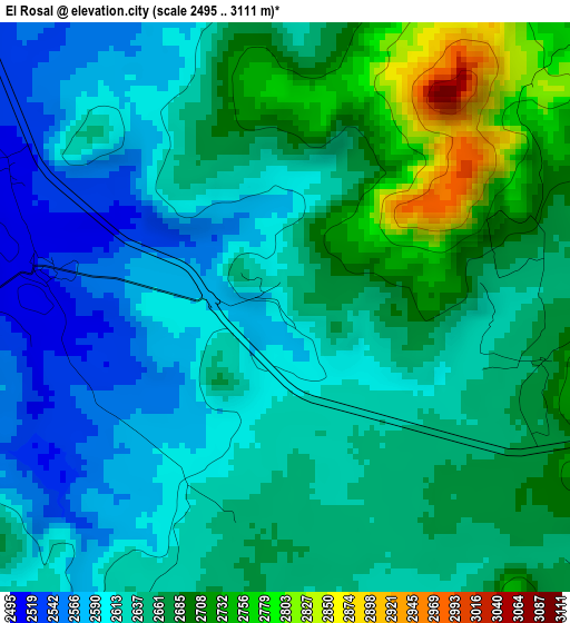
Below is the Elevation map of El Rosal, which displays elevation range with different colors. Scale of the first map is from 2495 to 3111 m (8186 to 10207 ft) with average elevation of 2645.5 meters (=8679 ft) [note 1]
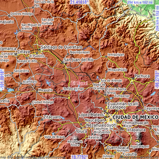
These maps also provides idea of topography and contour of this city, they are displayed at different zoom levels. More info about maps, scale and edge coordinates you can find below images.
| \ | Map #1 | Topo.Map |
| Scale [m] | 2495..3111 m | × |
| Scale [ft] | 8186..10207 ft | × |
| Average | 2645.5 m = 8679 ft | × |
| Width | 9.18 km = 5.7 mi | 293.6 km = 182.4 mi |
| Height | 9.18 km = 5.7 mi | 293.7 km = 182.5 mi |
| ↑Max Latitude | 20.142523° | 21.41618° |
| Latitude at center | 20.10126° | 20.10126° |
| ↓Min Latitude | 20.059986° | 18.7752° |
| ← Min Longitude | -99.729495° | -101.0918° |
| Longitude center | -99.68555° | -99.68555° |
| →Max Longitude | -99.641605° | -98.2793° |
Nearby cities:
Cities around El Rosal sort by population:
• Canalejas elevation 2728 m
16 km,  148°
148°
• San Miguel de La Victoria 2561 m
11.1 km,  116°
116°
• La Comunidad 2568 m
14.5 km,  127°
127°
• San Lorenzo Nenamicoyan 2773 m
6.3 km,  50°
50°
• San Martín Tuchicuitlapilco 2666 m
4.1 km,  101°
101°
• San Martín Ejido 2648 m
3.4 km,  194°
194°
• Aculco de Espinoza 2449 m
14.8 km,  268°
268°
• La Soledad Barrio 2462 m
14.4 km, 265°
• Santa María Nativitas 2432 m
11.8 km,  264°
264°
• San Vicente (Calpulalpan Tercera Manzana) 2705 m
8.5 km, 147°
• Santiago Oxthoc 2398 m
14.8 km,  83°
83°
• El Colorado 2545 m
8.1 km, 266°
Multilingual:
 En español:
El Rosal elevación 2610 m.
 En France:
El Rosal élévation 2610 m.
 Auf Deutsch:
El Rosal höhe über dem Meeresspiegel ist 2610 m.

Sources and notes:
- [note 1] Map square and city borders are not equal. Map elevation data is calculated only from area inside that square.
- [src 1] Elevation data from geonames database provided with same terms of usage.
- [src 2] The elevation map of El Rosal is generated using elevation data from NASA's 3 arcsec (90m) resolution SRTM data.
- [src 3] Base (background) map © OpenStreetMap contributors tiles are generated by Geofabrik and OpenTopoMap.
Copyright & License:
This El Rosal Elevation Map is licensed under CC BY-SA. You may reuse any part from this page, if you give a proper credit by linking to this URL:
 More info on terms of use page.