Xocotlán elevation
Xocotlán (State of Mexico, Texcoco), Mexico elevation is 2284 meters and Xocotlán elevation in feet is 7493 ft above sea level [src 1]. Xocotlán is a populated place (feature code) with elevation that is 970 meters (3182 ft) bigger than average city elevation in Mexico.
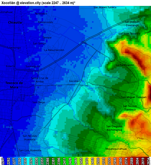
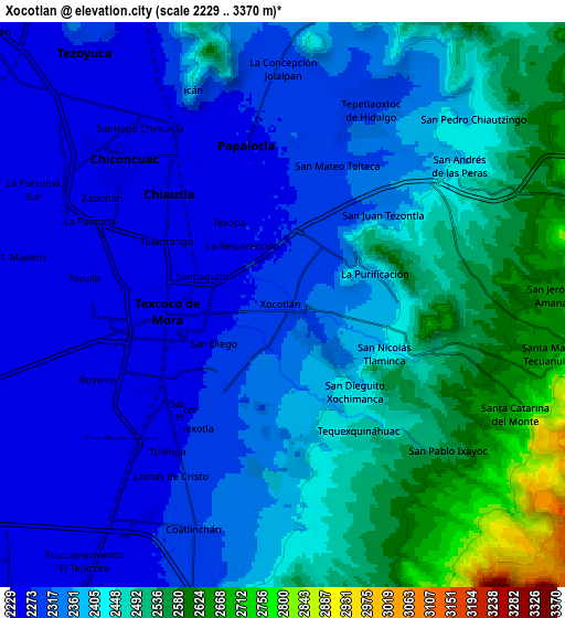
Below is the Elevation map of Xocotlán, which displays elevation range with different colors. Scale of the first map is from 2247 to 2634 m (7372 to 8642 ft) with average elevation of 2328.2 meters (=7638 ft) [note 1]
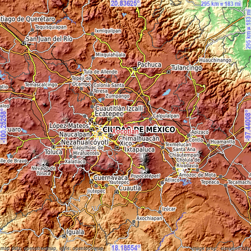
These maps also provides idea of topography and contour of this city, they are displayed at different zoom levels. More info about maps, scale and edge coordinates you can find below images.
| \ | Map #1 | Map #2 | Topo.Map |
| Scale [m] | 2247..2634 m | 2229..3370 m | × |
| Scale [ft] | 7372..8642 ft | 7313..11056 ft | × |
| Average | 2328.2 m = 7638 ft | 2391.8 m = 7847 ft | × |
| Width | 9.21 km = 5.7 mi | 18.42 km = 11.4 mi | 294.7 km = 183.1 mi |
| Height | 9.21 km = 5.7 mi | 18.42 km = 11.4 mi | 294.8 km = 183.2 mi |
| ↑Max Latitude | 19.557745° | 19.59915° | 20.83625° |
| Latitude at center | 19.51633° | 19.51633° | 19.51633° |
| ↓Min Latitude | 19.474904° | 19.433468° | 18.18554° |
| ← Min Longitude | -98.890275° | -98.934221° | -100.25258° |
| Longitude center | -98.84633° | -98.84633° | -98.84633° |
| →Max Longitude | -98.802385° | -98.758439° | -97.44008° |
Nearby cities:
Cities around Xocotlán sort by population:
• Texcoco de Mora elevation 2257 m
3.9 km,  262°
262°
• Tulantongo 2259 m
3.4 km,  299°
299°
• Chiautla 2258 m
5.2 km,  313°
313°
• San Miguel Tlaixpan 2417 m
3.8 km,  101°
101°
• San Joaquín Coapango 2297 m
3.3 km,  36°
36°
• Tequexquináhuac 2461 m
4.9 km,  152°
152°
• Xochimanca 2428 m
3.7 km,  141°
141°
• Papalotla 2270 m
5.3 km,  348°
348°
• La Purificación 2377 m
3.2 km,  73°
73°
• Colonia Tulteca Teopan 2283 m
5 km,  2°
2°
• Ejido San Cristóbal 2254 m
5.8 km, 300°
• Atenguillo 2262 m
6.1 km,  329°
329°
Multilingual:
 En español:
Xocotlán elevación 2284 m.
 En France:
Xocotlán élévation 2284 m.
 Auf Deutsch:
Xocotlán höhe über dem Meeresspiegel ist 2284 m.

Sources and notes:
- [note 1] Map square and city borders are not equal. Map elevation data is calculated only from area inside that square.
- [src 1] Elevation data from geonames database provided with same terms of usage.
- [src 2] The elevation map of Xocotlán is generated using elevation data from NASA's 3 arcsec (90m) resolution SRTM data.
- [src 3] Base (background) map © OpenStreetMap contributors tiles are generated by Geofabrik and OpenTopoMap.
Copyright & License:
This Xocotlán Elevation Map is licensed under CC BY-SA. You may reuse any part from this page, if you give a proper credit by linking to this URL:
 More info on terms of use page.