Santiago Oxtotitlán elevation
Santiago Oxtotitlán (State of Mexico, Villa Guerrero), Mexico elevation is 2193 meters and Santiago Oxtotitlán elevation in feet is 7195 ft above sea level [src 1]. Santiago Oxtotitlán is a populated place (feature code) with elevation that is 879 meters (2884 ft) bigger than average city elevation in Mexico.
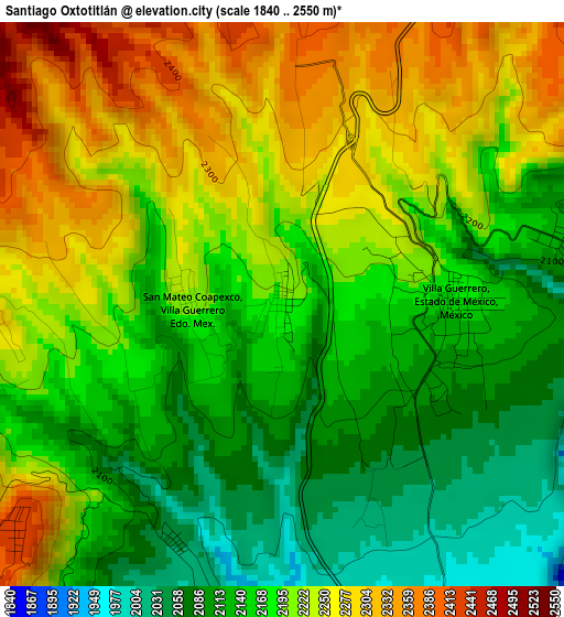
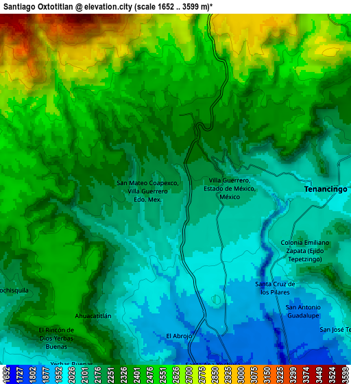
Below is the Elevation map of Santiago Oxtotitlán, which displays elevation range with different colors. Scale of the first map is from 1840 to 2550 m (6037 to 8366 ft) with average elevation of 2190.7 meters (=7187 ft) [note 1]
These maps also provides idea of topography and contour of this city, they are displayed at different zoom levels. More info about maps, scale and edge coordinates you can find below images.
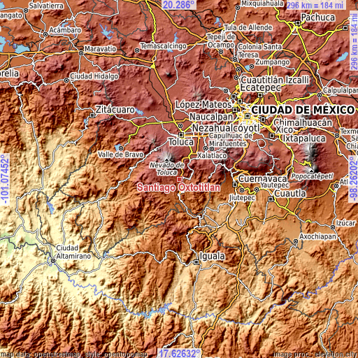
| \ | Map #1 | Map #2 | Topo.Map |
| Scale [m] | 1840..2550 m | 1652..3599 m | × |
| Scale [ft] | 6037..8366 ft | 5420..11808 ft | × |
| Average | 2190.7 m = 7187 ft | 2299.7 m = 7545 ft | × |
| Width | 9.24 km = 5.7 mi | 18.48 km = 11.5 mi | 295.7 km = 183.7 mi |
| Height | 9.24 km = 5.7 mi | 18.48 km = 11.5 mi | 295.7 km = 183.7 mi |
| ↑Max Latitude | 19.003016° | 19.044561° | 20.286° |
| Latitude at center | 18.96146° | 18.96146° | 18.96146° |
| ↓Min Latitude | 18.919894° | 18.878318° | 17.62632° |
| ← Min Longitude | -99.712215° | -99.756161° | -101.07452° |
| Longitude center | -99.66827° | -99.66827° | -99.66827° |
| →Max Longitude | -99.624325° | -99.580379° | -98.26202° |
Nearby cities:
Cities around Santiago Oxtotitlán sort by population:
• Villa Guerrero elevation 2170 m
2.9 km,  88°
88°
• Zacango 2198 m
3.2 km,  259°
259°
• San Francisco 2097 m
2.6 km,  121°
121°
• San Mateo Coapexco 2209 m
1.6 km,  270°
270°
• Santa María Aranzazú (Santa María) 2309 m
3.5 km,  31°
31°
• Buenavista 2104 m
2.1 km,  146°
146°
• Totolmajac 2043 m
4.3 km,  205°
205°
• San Miguel 2352 m
3.3 km,  4°
4°
• San Lucas 2283 m
2 km,  23°
23°
• Ejido de San Mateo Coapexco 2083 m
3.1 km, 117°
• San Gaspar 2197 m
3.6 km,  253°
253°
• La Joya 2244 m
2 km,  52°
52°
Multilingual:
 En español:
Santiago Oxtotitlán elevación 2193 m.
 En France:
Santiago Oxtotitlán élévation 2193 m.
 Auf Deutsch:
Santiago Oxtotitlán höhe über dem Meeresspiegel ist 2193 m.
 На русском:
Santiago Oxtotitlán высота над уровнем моря 2193 м
Sources and notes:
- [note 1] Map square and city borders are not equal. Map elevation data is calculated only from area inside that square.
- [src 1] Elevation data from geonames database provided with same terms of usage.
- [src 2] The elevation map of Santiago Oxtotitlán is generated using elevation data from NASA's 3 arcsec (90m) resolution SRTM data.
- [src 3] Base (background) map © OpenStreetMap contributors tiles are generated by Geofabrik and OpenTopoMap.
Copyright & License:
This Santiago Oxtotitlán Elevation Map is licensed under CC BY-SA. You may reuse any part from this page, if you give a proper credit by linking to this URL:
 More info on terms of use page.