Pilcaya elevation
Pilcaya (Guerrero), Mexico elevation is 1623 meters and Pilcaya elevation in feet is 5325 ft above sea level [src 1]. Pilcaya is a seat of a second-order administrative division (feature code) with elevation that is 309 meters (1014 ft) bigger than average city elevation in Mexico.
Below is the Elevation map of Pilcaya, which displays elevation range with different colors. Scale of the first map is from 1234 to 2048 m (4049 to 6719 ft) with average elevation of 1569.3 meters (=5149 ft) [note 1]
These maps also provides idea of topography and contour of this city, they are displayed at different zoom levels. More info about maps, scale and edge coordinates you can find below images.
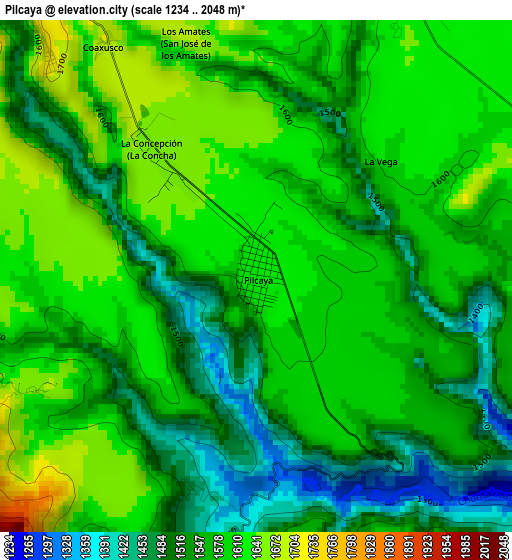
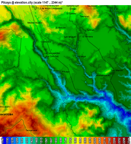
| \ | Map #1 | Map #2 | Topo.Map |
| Scale [m] | 1234..2048 m | 1147..2344 m | × |
| Scale [ft] | 4049..6719 ft | 3763..7690 ft | × |
| Average | 1569.3 m = 5149 ft | 1668.5 m = 5474 ft | × |
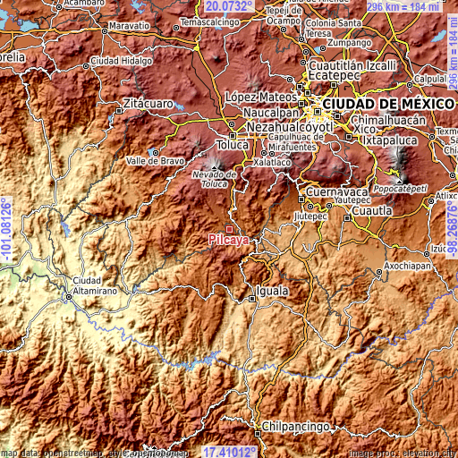
| Width | 9.25 km = 5.7 mi | 18.51 km = 11.5 mi | 296.1 km = 184 mi |
| Height | 9.25 km = 5.7 mi | 18.51 km = 11.5 mi | 296.1 km = 184 mi |
| ↑Max Latitude | 18.788519° | 18.830117° | 20.0732° |
| Latitude at center | 18.74691° | 18.74691° | 18.74691° |
| ↓Min Latitude | 18.705291° | 18.663662° | 17.41012° |
| ← Min Longitude | -99.718955° | -99.762901° | -101.08126° |
| Longitude center | -99.67501° | -99.67501° | -99.67501° |
| →Max Longitude | -99.631065° | -99.587119° | -98.26876° |
Nearby cities:
Cities around Pilcaya sort by population:
• Ixtapan de la Sal elevation 1871 m
10.8 km,  359°
359°
• San Gaspar Tonatico 1678 m
6.7 km,  5°
5°
• Zacualpan 2057 m
11.1 km,  253°
253°
• Tetipac 1676 m
11.4 km,  165°
165°
• Tecomatepec 1819 m
10.7 km,  343°
343°
• San Alejo 1851 m
11.7 km,  330°
330°
• El Terrero 1621 m
5.7 km,  32°
32°
• Llano Grande 1887 m
13.2 km,  312°
312°
• La Concepción (La Concha) 1665 m
3 km,  321°
321°
• Colonia 3 de Mayo 1790 m
9.1 km,  348°
348°
• Huitzoltepec 1965 m
13.4 km,  279°
279°
• El Progreso Hidalgo 1716 m
12.8 km, 30°
Multilingual:
 En español:
Pilcaya elevación 1623 m.
 En France:
Pilcaya élévation 1623 m.
 Auf Deutsch:
Pilcaya höhe über dem Meeresspiegel ist 1623 m.

Sources and notes:
- [note 1] Map square and city borders are not equal. Map elevation data is calculated only from area inside that square.
- [src 1] Elevation data from geonames database provided with same terms of usage.
- [src 2] The elevation map of Pilcaya is generated using elevation data from NASA's 3 arcsec (90m) resolution SRTM data.
- [src 3] Base (background) map © OpenStreetMap contributors tiles are generated by Geofabrik and OpenTopoMap.
Copyright & License:
This Pilcaya Elevation Map is licensed under CC BY-SA. You may reuse any part from this page, if you give a proper credit by linking to this URL:
 More info on terms of use page.