Santa María elevation
Santa María (Chiapas, Salto de Agua), Mexico elevation is 113 meters and Santa María elevation in feet is 371 ft above sea level [src 1]. Santa María is a populated place (feature code) with elevation that is 1201 meters (3940 ft) smaller than average city elevation in Mexico.
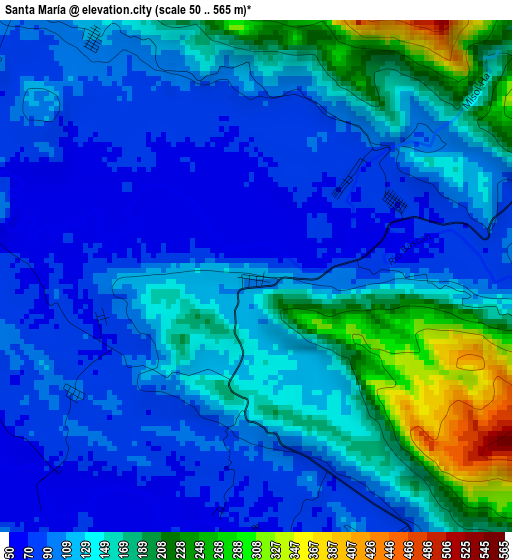
Below is the Elevation map of Santa María, which displays elevation range with different colors. Scale of the first map is from 50 to 565 m (164 to 1854 ft) with average elevation of 132.3 meters (=434 ft) [note 1]
These maps also provides idea of topography and contour of this city, they are displayed at different zoom levels. More info about maps, scale and edge coordinates you can find below images.
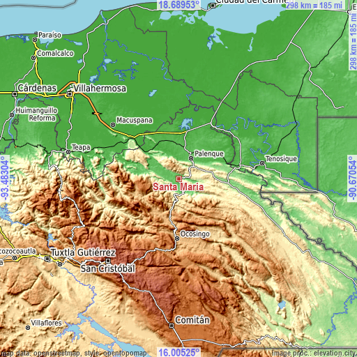
| \ | Map #1 | Topo.Map |
| Scale [m] | 50..565 m | × |
| Scale [ft] | 164..1854 ft | × |
| Average | 132.3 m = 434 ft | × |
| Width | 9.33 km = 5.8 mi | 298.5 km = 185.5 mi |
| Height | 9.33 km = 5.8 mi | 298.5 km = 185.5 mi |
| ↑Max Latitude | 17.394241° | 18.68953° |
| Latitude at center | 17.3523° | 17.3523° |
| ↓Min Latitude | 17.31035° | 16.00525° |
| ← Min Longitude | -92.120735° | -93.48304° |
| Longitude center | -92.07679° | -92.07679° |
| →Max Longitude | -92.032845° | -90.67054° |
Nearby cities:
Cities around Santa María sort by population:
• Palenque elevation 75 m
20.1 km,  29°
29°
• Egipto 98 m
15 km,  131°
131°
• Belisario Domínguez 321 m
11.6 km,  58°
58°
• San Miguel 178 m
7.4 km,  80°
80°
• Doctor Samuel León Brindis 228 m
17.9 km, 59°
• Ignacio Zaragoza 363 m
8 km,  36°
36°
• Río Jordán 139 m
19.3 km, 127°
• Profresor Roberto Barrios 156 m
16.2 km,  100°
100°
• Estrella de Belén 283 m
13.1 km,  72°
72°
• Jerusalén 75 m
2.4 km, 44°
• El Mango 621 m
21.2 km,  175°
175°
• Arroyo Palenque 116 m
5.3 km,  326°
326°
Multilingual:
 En español:
Santa María elevación 113 m.
 En France:
Santa María élévation 113 m.
 Auf Deutsch:
Santa María höhe über dem Meeresspiegel ist 113 m.

Sources and notes:
- [note 1] Map square and city borders are not equal. Map elevation data is calculated only from area inside that square.
- [src 1] Elevation data from geonames database provided with same terms of usage.
- [src 2] The elevation map of Santa María is generated using elevation data from NASA's 3 arcsec (90m) resolution SRTM data.
- [src 3] Base (background) map © OpenStreetMap contributors tiles are generated by Geofabrik and OpenTopoMap.
Copyright & License:
This Santa María Elevation Map is licensed under CC BY-SA. You may reuse any part from this page, if you give a proper credit by linking to this URL:
 More info on terms of use page.