Ubilio García elevation
Ubilio García (Chiapas, Ocosingo), Mexico elevation is 366 meters and Ubilio García elevation in feet is 1201 ft above sea level [src 1]. Ubilio García is a populated place (feature code) with elevation that is 948 meters (3110 ft) smaller than average city elevation in Mexico.
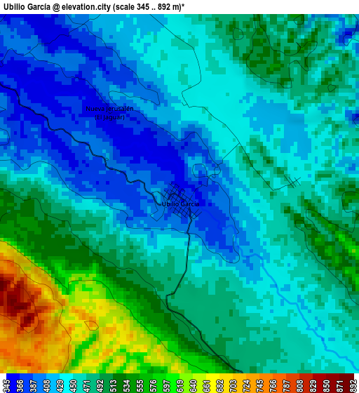
Below is the Elevation map of Ubilio García, which displays elevation range with different colors. Scale of the first map is from 345 to 892 m (1132 to 2927 ft) with average elevation of 473 meters (=1552 ft) [note 1]
These maps also provides idea of topography and contour of this city, they are displayed at different zoom levels. More info about maps, scale and edge coordinates you can find below images.
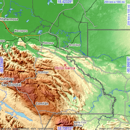
| \ | Map #1 | Topo.Map |
| Scale [m] | 345..892 m | × |
| Scale [ft] | 1132..2927 ft | × |
| Average | 473 m = 1552 ft | × |
| Width | 9.34 km = 5.8 mi | 298.9 km = 185.7 mi |
| Height | 9.34 km = 5.8 mi | 298.9 km = 185.7 mi |
| ↑Max Latitude | 17.126051° | 18.42329° |
| Latitude at center | 17.08405° | 17.08405° |
| ↓Min Latitude | 17.042039° | 15.73512° |
| ← Min Longitude | -91.516355° | -92.87866° |
| Longitude center | -91.47241° | -91.47241° |
| →Max Longitude | -91.428465° | -90.06616° |
Nearby cities:
Cities around Ubilio García sort by population:
• Damasco elevation 356 m
16.1 km,  302°
302°
• Cristóbal Colón 318 m
20.5 km,  305°
305°
• Santo Domingo 466 m
8.6 km,  136°
136°
• Cintalapa 491 m
21.4 km,  146°
146°
• Santa Elena 671 m
24.7 km,  210°
210°
• El Sibal 685 m
11.7 km,  189°
189°
• Nuevo Francisco León 159 m
17.1 km,  110°
110°
• Arroyo Granizo 458 m
7.2 km, 136°
• El Limonar 492 m
16.1 km, 141°
• Zaragoza 1117 m
19.7 km,  244°
244°
• Lacandón 803 m
14.8 km, 241°
• El Tumbo 619 m
16.3 km,  267°
267°
Multilingual:
 En español:
Ubilio García elevación 366 m.
 En France:
Ubilio García élévation 366 m.
 Auf Deutsch:
Ubilio García höhe über dem Meeresspiegel ist 366 m.

Sources and notes:
- [note 1] Map square and city borders are not equal. Map elevation data is calculated only from area inside that square.
- [src 1] Elevation data from geonames database provided with same terms of usage.
- [src 2] The elevation map of Ubilio García is generated using elevation data from NASA's 3 arcsec (90m) resolution SRTM data.
- [src 3] Base (background) map © OpenStreetMap contributors tiles are generated by Geofabrik and OpenTopoMap.
Copyright & License:
This Ubilio García Elevation Map is licensed under CC BY-SA. You may reuse any part from this page, if you give a proper credit by linking to this URL:
 More info on terms of use page.