El Rosario elevation
El Rosario (Hidalgo, Francisco I. Madero), Mexico elevation is 1987 meters and El Rosario elevation in feet is 6519 ft above sea level [src 1]. El Rosario is a populated place (feature code) with elevation that is 673 meters (2208 ft) bigger than average city elevation in Mexico.
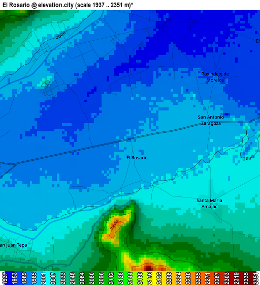
Below is the Elevation map of El Rosario, which displays elevation range with different colors. Scale of the first map is from 1937 to 2351 m (6355 to 7713 ft) with average elevation of 1999.6 meters (=6560 ft) [note 1]
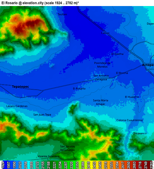
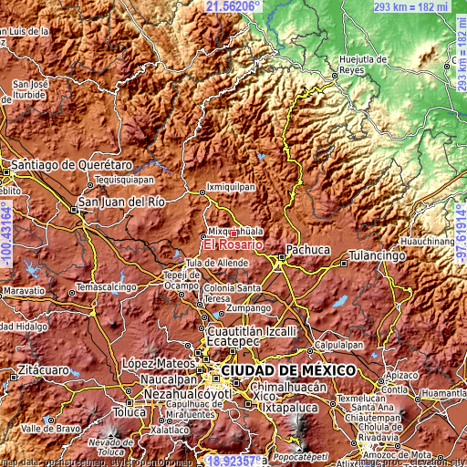
These maps also provides idea of topography and contour of this city, they are displayed at different zoom levels. More info about maps, scale and edge coordinates you can find below images.
| \ | Map #1 | Map #2 | Topo.Map |
| Scale [m] | 1937..2351 m | 1924..2782 m | × |
| Scale [ft] | 6355..7713 ft | 6312..9127 ft | × |
| Average | 1999.6 m = 6560 ft | 2086.5 m = 6845 ft | × |
| Width | 9.17 km = 5.7 mi | 18.34 km = 11.4 mi | 293.4 km = 182.3 mi |
| Height | 9.17 km = 5.7 mi | 18.34 km = 11.4 mi | 293.4 km = 182.3 mi |
| ↑Max Latitude | 20.289644° | 20.330857° | 21.56206° |
| Latitude at center | 20.24842° | 20.24842° | 20.24842° |
| ↓Min Latitude | 20.207185° | 20.165939° | 18.92357° |
| ← Min Longitude | -99.069335° | -99.113281° | -100.43164° |
| Longitude center | -99.02539° | -99.02539° | -99.02539° |
| →Max Longitude | -98.981445° | -98.937499° | -97.61914° |
Nearby cities:
Cities around El Rosario sort by population:
• Tepatepec elevation 1982 m
6.7 km,  267°
267°
• San Juan Tepa 2018 m
5.6 km,  229°
229°
• San Antonio Zaragoza 1995 m
2.9 km,  75°
75°
• El Huaxtho 2001 m
6.8 km,  103°
103°
• Caxuxi 1967 m
7.3 km,  29°
29°
• El Boxtha 1966 m
5.5 km, 76°
• Daxtha 1958 m
5.9 km,  53°
53°
• Lázaro Cárdenas 2015 m
7.7 km,  250°
250°
• Santa María Amajac 2015 m
3.5 km,  126°
126°
• El Colorado 2059 m
4.4 km,  146°
146°
• San Salvador 1949 m
4.3 km,  15°
15°
• El Olvera 1955 m
2.4 km,  359°
359°
Multilingual:
 En español:
El Rosario elevación 1987 m.
 En France:
El Rosario élévation 1987 m.
 Auf Deutsch:
El Rosario höhe über dem Meeresspiegel ist 1987 m.

Sources and notes:
- [note 1] Map square and city borders are not equal. Map elevation data is calculated only from area inside that square.
- [src 1] Elevation data from geonames database provided with same terms of usage.
- [src 2] The elevation map of El Rosario is generated using elevation data from NASA's 3 arcsec (90m) resolution SRTM data.
- [src 3] Base (background) map © OpenStreetMap contributors tiles are generated by Geofabrik and OpenTopoMap.
Copyright & License:
This El Rosario Elevation Map is licensed under CC BY-SA. You may reuse any part from this page, if you give a proper credit by linking to this URL:
 More info on terms of use page.