Bomintzha elevation
Bomintzha (Hidalgo, Tula de Allende), Mexico elevation is 2233 meters and Bomintzha elevation in feet is 7326 ft above sea level [src 1]. Bomintzha is a populated place (feature code) with elevation that is 919 meters (3015 ft) bigger than average city elevation in Mexico.
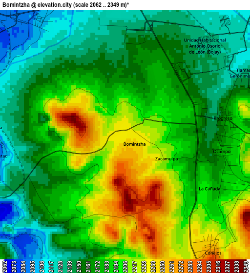
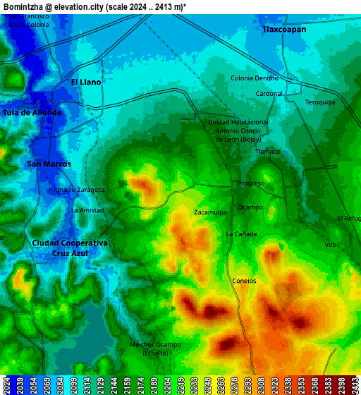
Below is the Elevation map of Bomintzha, which displays elevation range with different colors. Scale of the first map is from 2062 to 2349 m (6765 to 7707 ft) with average elevation of 2179.1 meters (=7149 ft) [note 1]
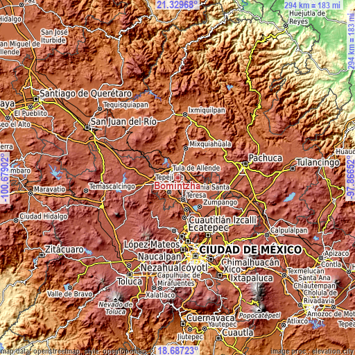
These maps also provides idea of topography and contour of this city, they are displayed at different zoom levels. More info about maps, scale and edge coordinates you can find below images.
| \ | Map #1 | Map #2 | Topo.Map |
| Scale [m] | 2062..2349 m | 2024..2413 m | × |
| Scale [ft] | 6765..7707 ft | 6640..7917 ft | × |
| Average | 2179.1 m = 7149 ft | 2155.6 m = 7072 ft | × |
| Width | 9.18 km = 5.7 mi | 18.36 km = 11.4 mi | 293.8 km = 182.6 mi |
| Height | 9.18 km = 5.7 mi | 18.36 km = 11.4 mi | 293.8 km = 182.6 mi |
| ↑Max Latitude | 20.055286° | 20.096561° | 21.32968° |
| Latitude at center | 20.014° | 20.014° | 20.014° |
| ↓Min Latitude | 19.972703° | 19.931396° | 18.68723° |
| ← Min Longitude | -99.316715° | -99.360661° | -100.67902° |
| Longitude center | -99.27277° | -99.27277° | -99.27277° |
| →Max Longitude | -99.228825° | -99.184879° | -97.86652° |
Nearby cities:
Cities around Bomintzha sort by population:
• Atotonilco de Tula elevation 2163 m
5.8 km,  96°
96°
• San Miguel Vindho 2134 m
5.2 km,  245°
245°
• Conejos 2259 m
5.3 km,  144°
144°
• Tlamaco (San Gerónimo Tlamaco) 2134 m
5.1 km,  63°
63°
• Progreso 2160 m
3.6 km,  79°
79°
• Ignacio Zaragoza 2092 m
5 km,  272°
272°
• Unidad Habitacional Antonio Osorio de León (Bojay) 2132 m
4.4 km,  41°
41°
• La Amistad 2101 m
5 km,  262°
262°
• Cañada 2183 m
3.9 km,  117°
117°
• Ocampo 2176 m
3.5 km, 99°
• Residencial Arboledas 2095 m
6.4 km,  331°
331°
• Zacamulpa 2198 m
1.9 km, 118°
Multilingual:
 En español:
Bomintzha elevación 2233 m.
 En France:
Bomintzha élévation 2233 m.
 Auf Deutsch:
Bomintzha höhe über dem Meeresspiegel ist 2233 m.

Sources and notes:
- [note 1] Map square and city borders are not equal. Map elevation data is calculated only from area inside that square.
- [src 1] Elevation data from geonames database provided with same terms of usage.
- [src 2] The elevation map of Bomintzha is generated using elevation data from NASA's 3 arcsec (90m) resolution SRTM data.
- [src 3] Base (background) map © OpenStreetMap contributors tiles are generated by Geofabrik and OpenTopoMap.
Copyright & License:
This Bomintzha Elevation Map is licensed under CC BY-SA. You may reuse any part from this page, if you give a proper credit by linking to this URL:
 More info on terms of use page.