San Juan Petlapa elevation
San Juan Petlapa (Oaxaca), Mexico elevation is 675 meters and San Juan Petlapa elevation in feet is 2215 ft above sea level [src 1]. San Juan Petlapa is a seat of a second-order administrative division (feature code) with elevation that is 639 meters (2096 ft) smaller than average city elevation in Mexico.
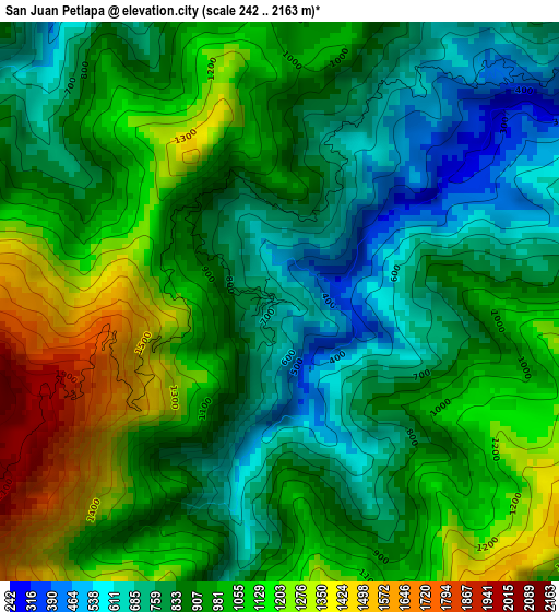
Below is the Elevation map of San Juan Petlapa, which displays elevation range with different colors. Scale of the first map is from 242 to 2163 m (794 to 7096 ft) with average elevation of 950.7 meters (=3119 ft) [note 1]
These maps also provides idea of topography and contour of this city, they are displayed at different zoom levels. More info about maps, scale and edge coordinates you can find below images.
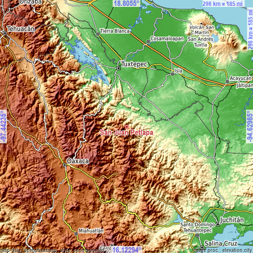
| \ | Map #1 | Topo.Map |
| Scale [m] | 242..2163 m | × |
| Scale [ft] | 794..7096 ft | × |
| Average | 950.7 m = 3119 ft | × |
| Width | 9.32 km = 5.8 mi | 298.3 km = 185.4 mi |
| Height | 9.32 km = 5.8 mi | 298.3 km = 185.4 mi |
| ↑Max Latitude | 17.511074° | 18.8055° |
| Latitude at center | 17.46916° | 17.46916° |
| ↓Min Latitude | 17.427237° | 16.12294° |
| ← Min Longitude | -96.080045° | -97.44235° |
| Longitude center | -96.0361° | -96.0361° |
| →Max Longitude | -95.992155° | -94.62985° |
Nearby cities:
Cities around San Juan Petlapa sort by population:
• Río Chiquito elevation 82 m
19.8 km,  32°
32°
• Ignacio Zaragoza 248 m
16.8 km,  63°
63°
• San Ildefonso Villa Alta 1236 m
19.1 km,  220°
220°
• Montenegro la Lana 79 m
22.8 km,  52°
52°
• San Cristóbal Lachirioag 1254 m
20.2 km, 222°
• Santiago Choápam 911 m
17.1 km,  134°
134°
• Santa María Temaxcalapa 1077 m
16.6 km,  233°
233°
• Santo Domingo Roayaga 1616 m
16.8 km,  209°
209°
• Santiago Lalopa 1215 m
23.3 km,  255°
255°
• San Andrés Yaá 1563 m
23.2 km, 212°
• San Juan Yatzona 1312 m
15.9 km,  241°
241°
• Santiago Camotlán 1413 m
16 km, 260°
Multilingual:
 En español:
San Juan Petlapa elevación 675 m.
 En France:
San Juan Petlapa élévation 675 m.
 Auf Deutsch:
San Juan Petlapa höhe über dem Meeresspiegel ist 675 m.

Sources and notes:
- [note 1] Map square and city borders are not equal. Map elevation data is calculated only from area inside that square.
- [src 1] Elevation data from geonames database provided with same terms of usage.
- [src 2] The elevation map of San Juan Petlapa is generated using elevation data from NASA's 3 arcsec (90m) resolution SRTM data.
- [src 3] Base (background) map © OpenStreetMap contributors tiles are generated by Geofabrik and OpenTopoMap.
Copyright & License:
This San Juan Petlapa Elevation Map is licensed under CC BY-SA. You may reuse any part from this page, if you give a proper credit by linking to this URL:
 More info on terms of use page.