Isla Soyaltepec elevation
Isla Soyaltepec (Oaxaca, San Miguel Soyaltepec), Mexico elevation is 208 meters and Isla Soyaltepec elevation in feet is 682 ft above sea level [src 1]. Isla Soyaltepec is a populated place (feature code) with elevation that is 1106 meters (3629 ft) smaller than average city elevation in Mexico.
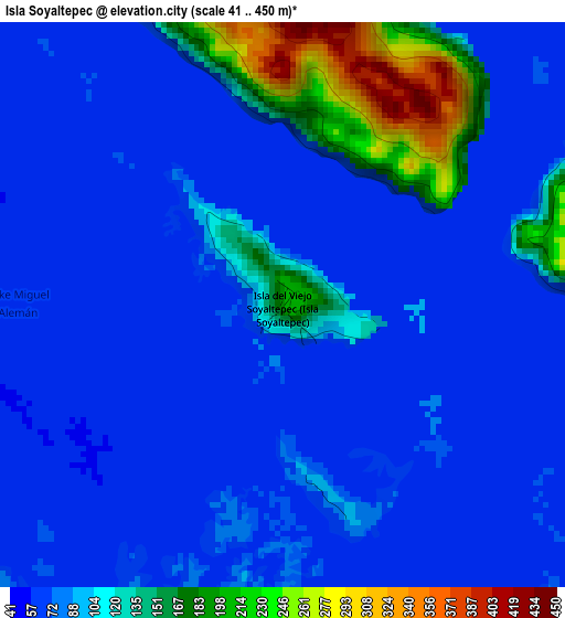
Below is the Elevation map of Isla Soyaltepec, which displays elevation range with different colors. Scale of the first map is from 41 to 450 m (135 to 1476 ft) with average elevation of 98 meters (=322 ft) [note 1]
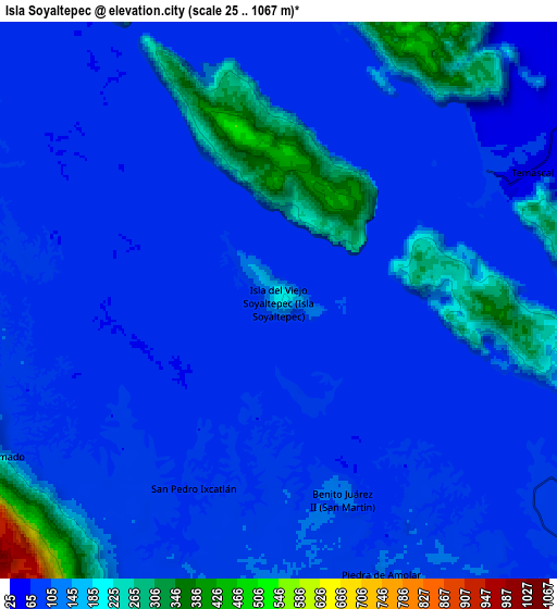
These maps also provides idea of topography and contour of this city, they are displayed at different zoom levels. More info about maps, scale and edge coordinates you can find below images.
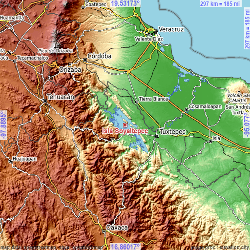
| \ | Map #1 | Map #2 | Topo.Map |
| Scale [m] | 41..450 m | 25..1067 m | × |
| Scale [ft] | 135..1476 ft | 82..3501 ft | × |
| Average | 98 m = 322 ft | 112.9 m = 370 ft | × |
| Width | 9.28 km = 5.8 mi | 18.57 km = 11.5 mi | 297 km = 184.5 mi |
| Height | 9.28 km = 5.8 mi | 18.57 km = 11.5 mi | 297.1 km = 184.6 mi |
| ↑Max Latitude | 18.242812° | 18.284543° | 19.53173° |
| Latitude at center | 18.20107° | 18.20107° | 18.20107° |
| ↓Min Latitude | 18.159318° | 18.117557° | 16.86017° |
| ← Min Longitude | -96.527195° | -96.571141° | -97.8895° |
| Longitude center | -96.48325° | -96.48325° | -96.48325° |
| →Max Longitude | -96.439305° | -96.395359° | -95.077° |
Nearby cities:
Cities around Isla Soyaltepec sort by population:
• Temascal elevation 41 m
9.8 km,  61°
61°
• San Felipe Jalapa de Díaz 148 m
15.5 km,  200°
200°
• San Pedro Ixcatlán 91 m
6.7 km, 204°
• Piedra de Amolar 116 m
9.6 km,  159°
159°
• Benito Juárez II (San Martín) 120 m
7.1 km, 161°
• Playa Chica 94 m
16 km,  193°
193°
• Arroyo Chical (Nuevo Arroyo Chicali) 72 m
15.6 km,  83°
83°
• La Tabaquera 80 m
15.4 km,  12°
12°
• Arroyo Zapotillo 124 m
15.3 km, 204°
• Colonia la Central 105 m
13.2 km, 195°
• Cerro Quemado 230 m
11 km,  241°
241°
• San Felipe Tílpam 79 m
11 km,  262°
262°
Multilingual:
 En español:
Isla Soyaltepec, Isla San Miguel Soyaltepec elevación 208 m.
 En France:
Isla Soyaltepec élévation 208 m.
 Auf Deutsch:
Isla Soyaltepec höhe über dem Meeresspiegel ist 208 m.

Sources and notes:
- [note 1] Map square and city borders are not equal. Map elevation data is calculated only from area inside that square.
- [src 1] Elevation data from geonames database provided with same terms of usage.
- [src 2] The elevation map of Isla Soyaltepec is generated using elevation data from NASA's 3 arcsec (90m) resolution SRTM data.
- [src 3] Base (background) map © OpenStreetMap contributors tiles are generated by Geofabrik and OpenTopoMap.
Copyright & License:
This Isla Soyaltepec Elevation Map is licensed under CC BY-SA. You may reuse any part from this page, if you give a proper credit by linking to this URL:
 More info on terms of use page.