Tamazulapam Villa del Progreso elevation
Tamazulapam Villa del Progreso (Oaxaca, Villa de Tamazulápam del Progreso), Mexico elevation is 2017 meters and Tamazulapam Villa del Progreso elevation in feet is 6617 ft above sea level [src 1]. Tamazulapam Villa del Progreso is a populated place (feature code) with elevation that is 703 meters (2306 ft) bigger than average city elevation in Mexico.
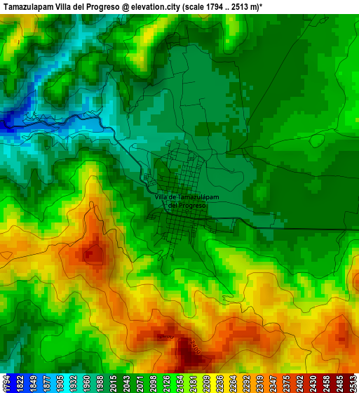
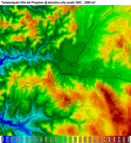
Below is the Elevation map of Tamazulapam Villa del Progreso, which displays elevation range with different colors. Scale of the first map is from 1794 to 2513 m (5886 to 8245 ft) with average elevation of 2105.7 meters (=6908 ft) [note 1]
These maps also provides idea of topography and contour of this city, they are displayed at different zoom levels. More info about maps, scale and edge coordinates you can find below images.
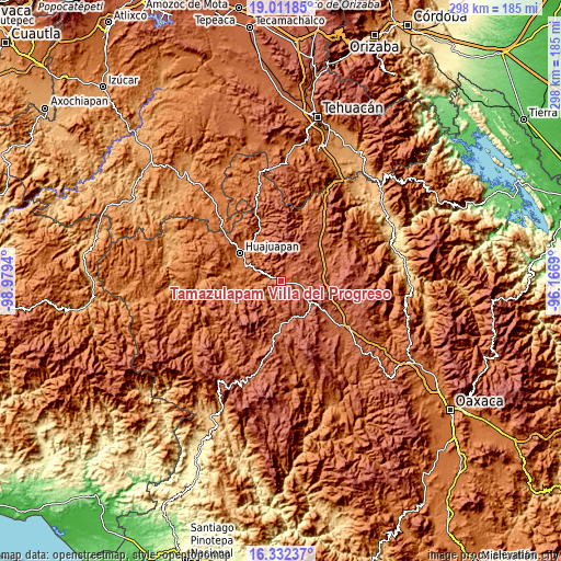
| \ | Map #1 | Map #2 | Topo.Map |
| Scale [m] | 1794..2513 m | 1683..2588 m | × |
| Scale [ft] | 5886..8245 ft | 5522..8491 ft | × |
| Average | 2105.7 m = 6908 ft | 2127.6 m = 6980 ft | × |
| Width | 9.31 km = 5.8 mi | 18.62 km = 11.6 mi | 297.9 km = 185.1 mi |
| Height | 9.31 km = 5.8 mi | 18.62 km = 11.6 mi | 298 km = 185.2 mi |
| ↑Max Latitude | 17.718965° | 17.760821° | 19.01185° |
| Latitude at center | 17.6771° | 17.6771° | 17.6771° |
| ↓Min Latitude | 17.635225° | 17.59334° | 16.33237° |
| ← Min Longitude | -97.617095° | -97.661041° | -98.9794° |
| Longitude center | -97.57315° | -97.57315° | -97.57315° |
| →Max Longitude | -97.529205° | -97.485259° | -96.1669° |
Nearby cities:
Cities around Tamazulapam Villa del Progreso sort by population:
• Santiago Huajolotitlán elevation 1641 m
23.8 km,  314°
314°
• El Molino 1667 m
21.9 km,  299°
299°
• Santiago Yolomécatl 2150 m
22.8 km,  179°
179°
• San Pedro y San Pablo Teposcolula 2173 m
20.5 km,  153°
153°
• Santa María Chilapa de Díaz 2416 m
21.3 km,  213°
213°
• Vista Hermosa 1653 m
23.6 km, 304°
• San Sebastián Nicananduta 2401 m
21.2 km, 213°
• Villa Tejúpam de la Unión 2115 m
11 km,  98°
98°
• San Andrés Dinicuiti 1686 m
16.3 km,  274°
274°
• La Junta 1614 m
24.8 km, 312°
• Santiago Cacaloxtepec 1715 m
18.4 km,  285°
285°
• Santo Domingo Yodohino 1654 m
13.4 km,  240°
240°
Multilingual:
 En español:
Tamazulapam Villa del Progreso elevación 2017 m.
 En France:
Tamazulapam Villa del Progreso élévation 2017 m.
 Auf Deutsch:
Tamazulapam Villa del Progreso höhe über dem Meeresspiegel ist 2017 m.
 На русском:
Tamazulapam Villa del Progreso высота над уровнем моря 2017 м
Sources and notes:
- [note 1] Map square and city borders are not equal. Map elevation data is calculated only from area inside that square.
- [src 1] Elevation data from geonames database provided with same terms of usage.
- [src 2] The elevation map of Tamazulapam Villa del Progreso is generated using elevation data from NASA's 3 arcsec (90m) resolution SRTM data.
- [src 3] Base (background) map © OpenStreetMap contributors tiles are generated by Geofabrik and OpenTopoMap.
Copyright & License:
This Tamazulapam Villa del Progreso Elevation Map is licensed under CC BY-SA. You may reuse any part from this page, if you give a proper credit by linking to this URL:
 More info on terms of use page.