El Chocolate elevation
El Chocolate (Oaxaca, San Juan Guichicovi), Mexico elevation is 261 meters and El Chocolate elevation in feet is 856 ft above sea level [src 1]. El Chocolate is a populated place (feature code) with elevation that is 1053 meters (3455 ft) smaller than average city elevation in Mexico.
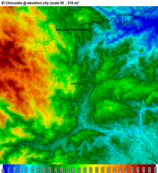
Below is the Elevation map of El Chocolate, which displays elevation range with different colors. Scale of the first map is from 95 to 518 m (312 to 1699 ft) with average elevation of 268.2 meters (=880 ft) [note 1]
These maps also provides idea of topography and contour of this city, they are displayed at different zoom levels. More info about maps, scale and edge coordinates you can find below images.
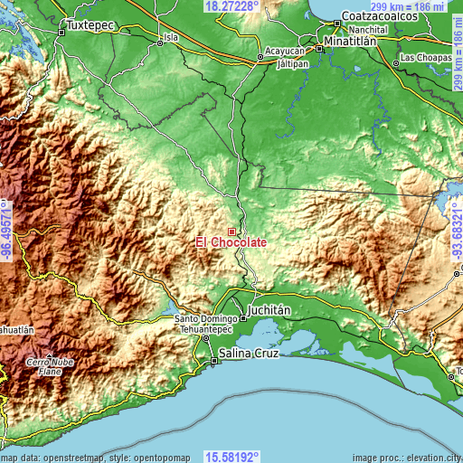
| \ | Map #1 | Topo.Map |
| Scale [m] | 95..518 m | × |
| Scale [ft] | 312..1699 ft | × |
| Average | 268.2 m = 880 ft | × |
| Width | 9.35 km = 5.8 mi | 299.1 km = 185.9 mi |
| Height | 9.35 km = 5.8 mi | 299.2 km = 185.9 mi |
| ↑Max Latitude | 16.973946° | 18.27228° |
| Latitude at center | 16.93191° | 16.93191° |
| ↓Min Latitude | 16.889865° | 15.58192° |
| ← Min Longitude | -95.133405° | -96.49571° |
| Longitude center | -95.08946° | -95.08946° |
| →Max Longitude | -95.045515° | -93.68321° |
Nearby cities:
Cities around El Chocolate sort by population:
• Matías Romero elevation 208 m
7.9 km,  137°
137°
• Colonia Rincón Viejo 202 m
6.7 km, 138°
• San Juan Guichicovi 264 m
3.4 km,  351°
351°
• Llano Suchiapa 227 m
8.2 km,  152°
152°
• Santa María Petapa 245 m
12.8 km,  194°
194°
• El Bajío 209 m
7.5 km,  129°
129°
• Estación Mogoñé 103 m
9 km,  38°
38°
• Río Pachiñe 148 m
4.8 km,  32°
32°
• Piedra Blanca 114 m
10.3 km,  52°
52°
• Zacatal 550 m
12.1 km,  274°
274°
• Encinal Colorado 280 m
8.9 km, 347°
• Zarzal 109 m
10.7 km, 31°
Multilingual:
 En español:
Cocolate, El Chocolate elevación 261 m.
 En France:
El Chocolate élévation 261 m.
 Auf Deutsch:
El Chocolate höhe über dem Meeresspiegel ist 261 m.

Sources and notes:
- [note 1] Map square and city borders are not equal. Map elevation data is calculated only from area inside that square.
- [src 1] Elevation data from geonames database provided with same terms of usage.
- [src 2] The elevation map of El Chocolate is generated using elevation data from NASA's 3 arcsec (90m) resolution SRTM data.
- [src 3] Base (background) map © OpenStreetMap contributors tiles are generated by Geofabrik and OpenTopoMap.
Copyright & License:
This El Chocolate Elevation Map is licensed under CC BY-SA. You may reuse any part from this page, if you give a proper credit by linking to this URL:
 More info on terms of use page.