Acatzingo elevation
Acatzingo (Puebla), Mexico elevation is 2148 meters and Acatzingo elevation in feet is 7047 ft above sea level [src 1]. Acatzingo is a seat of a second-order administrative division (feature code) with elevation that is 834 meters (2736 ft) bigger than average city elevation in Mexico.
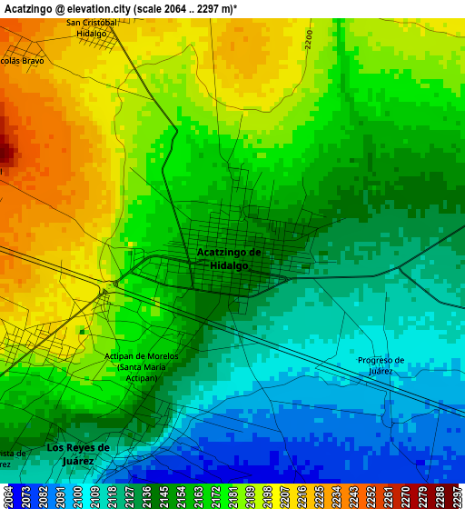
Below is the Elevation map of Acatzingo, which displays elevation range with different colors. Scale of the first map is from 2064 to 2297 m (6772 to 7536 ft) with average elevation of 2157.3 meters (=7078 ft) [note 1]
These maps also provides idea of topography and contour of this city, they are displayed at different zoom levels. More info about maps, scale and edge coordinates you can find below images.
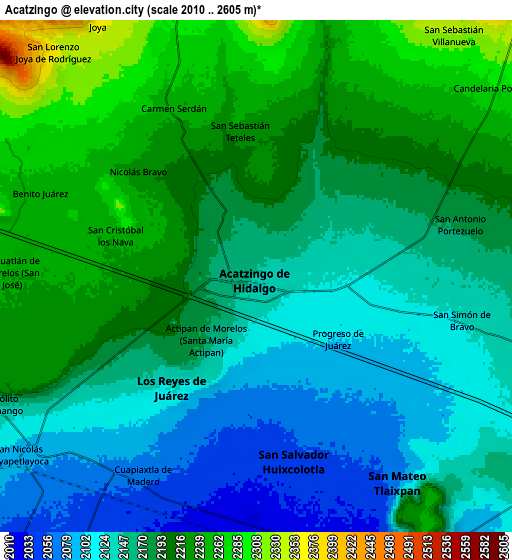
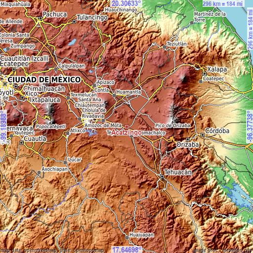
| \ | Map #1 | Map #2 | Topo.Map |
| Scale [m] | 2064..2297 m | 2010..2605 m | × |
| Scale [ft] | 6772..7536 ft | 6594..8547 ft | × |
| Average | 2157.3 m = 7078 ft | 2175.8 m = 7138 ft | × |
| Width | 9.24 km = 5.7 mi | 18.48 km = 11.5 mi | 295.7 km = 183.7 mi |
| Height | 9.24 km = 5.7 mi | 18.48 km = 11.5 mi | 295.7 km = 183.7 mi |
| ↑Max Latitude | 19.02351° | 19.06505° | 20.30633° |
| Latitude at center | 18.98196° | 18.98196° | 18.98196° |
| ↓Min Latitude | 18.940399° | 18.898828° | 17.64698° |
| ← Min Longitude | -97.827575° | -97.871521° | -99.18988° |
| Longitude center | -97.78363° | -97.78363° | -97.78363° |
| →Max Longitude | -97.739685° | -97.695739° | -96.37738° |
Nearby cities:
Cities around Acatzingo sort by population:
• Los Reyes de Juárez elevation 2133 m
4.2 km,  210°
210°
• Actipan de Morelos 2159 m
2.9 km, 213°
• Nicolás Bravo 2230 m
5.6 km,  312°
312°
• Santiago Acozac 2180 m
4.1 km,  226°
226°
• La Compañia 2124 m
6.5 km,  100°
100°
• San Sebastián Teteles 2242 m
5.7 km,  352°
352°
• Progreso de Juárez 2103 m
3.7 km,  127°
127°
• Buenavista de Juárez 2137 m
6.2 km, 228°
• San Cristóbal Hidalgo 2219 m
5.3 km,  327°
327°
• San Cristóbal los Nava 2244 m
5.3 km,  286°
286°
• Guadalupe Morelos 2225 m
5.3 km,  335°
335°
• Miguel Negrete 2165 m
5.8 km,  235°
235°
Multilingual:
 En español:
San Juan Acatzingo elevación 2148 m.
 En France:
Acatzingo élévation 2148 m.
 Auf Deutsch:
Acatzingo höhe über dem Meeresspiegel ist 2148 m.

Sources and notes:
- [note 1] Map square and city borders are not equal. Map elevation data is calculated only from area inside that square.
- [src 1] Elevation data from geonames database provided with same terms of usage.
- [src 2] The elevation map of Acatzingo is generated using elevation data from NASA's 3 arcsec (90m) resolution SRTM data.
- [src 3] Base (background) map © OpenStreetMap contributors tiles are generated by Geofabrik and OpenTopoMap.
Copyright & License:
This Acatzingo Elevation Map is licensed under CC BY-SA. You may reuse any part from this page, if you give a proper credit by linking to this URL:
 More info on terms of use page.