Actopan elevation
Actopan (Hidalgo), Mexico elevation is 2008 meters and Actopan elevation in feet is 6588 ft above sea level [src 1]. Actopan is a populated place (feature code) with elevation that is 694 meters (2277 ft) bigger than average city elevation in Mexico.
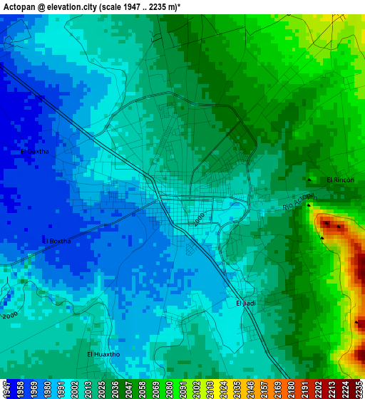
Below is the Elevation map of Actopan, which displays elevation range with different colors. Scale of the first map is from 1947 to 2235 m (6388 to 7333 ft) with average elevation of 2019 meters (=6624 ft) [note 1]
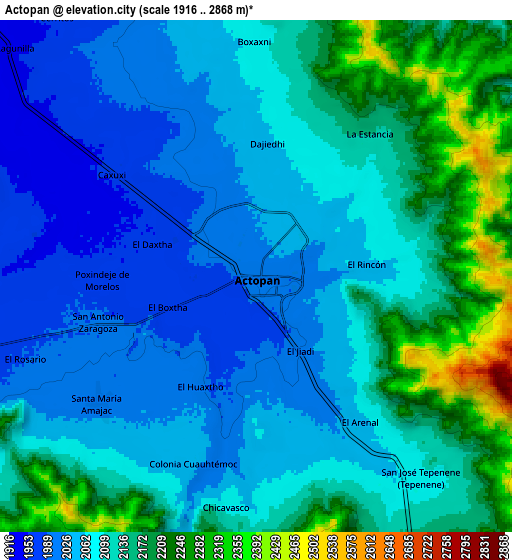
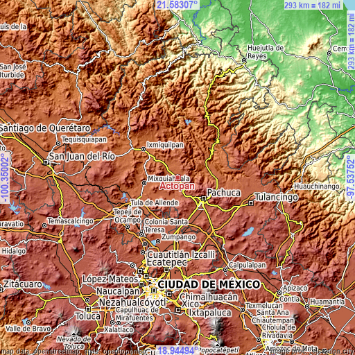
These maps also provides idea of topography and contour of this city, they are displayed at different zoom levels. More info about maps, scale and edge coordinates you can find below images.
| \ | Map #1 | Map #2 | Topo.Map |
| Scale [m] | 1947..2235 m | 1916..2868 m | × |
| Scale [ft] | 6388..7333 ft | 6286..9409 ft | × |
| Average | 2019 m = 6624 ft | 2104.2 m = 6904 ft | × |
| Width | 9.17 km = 5.7 mi | 18.33 km = 11.4 mi | 293.3 km = 182.2 mi |
| Height | 9.17 km = 5.7 mi | 18.33 km = 11.4 mi | 293.4 km = 182.3 mi |
| ↑Max Latitude | 20.310828° | 20.352036° | 21.58307° |
| Latitude at center | 20.26961° | 20.26961° | 20.26961° |
| ↓Min Latitude | 20.228381° | 20.18714° | 18.94494° |
| ← Min Longitude | -98.987715° | -99.031661° | -100.35002° |
| Longitude center | -98.94377° | -98.94377° | -98.94377° |
| →Max Longitude | -98.899825° | -98.855879° | -97.53752° |
Nearby cities:
Cities around Actopan sort by population:
• San Antonio Zaragoza elevation 1995 m
5.9 km,  254°
254°
• El Arenal 2050 m
6.3 km,  145°
145°
• El Huaxtho 2001 m
4.4 km,  206°
206°
• Caxuxi 1967 m
6.3 km,  308°
308°
• El Boxtha 1966 m
3.4 km, 250°
• El Jiadi 1998 m
2.9 km, 145°
• Daxtha 1958 m
3.9 km,  287°
287°
• Dajiedi 2049 m
4.6 km,  4°
4°
• Santa María Amajac 2015 m
7.2 km,  231°
231°
• La Estancia 2140 m
6.4 km,  38°
38°
• San Salvador 1949 m
7.6 km,  283°
283°
• El Rincón 2061 m
4.1 km,  84°
84°
Multilingual:
 En español:
Actopan elevación 2008 m.
 En France:
Actopan élévation 2008 m.
 Auf Deutsch:
Actopan höhe über dem Meeresspiegel ist 2008 m.

Sources and notes:
- [note 1] Map square and city borders are not equal. Map elevation data is calculated only from area inside that square.
- [src 1] Elevation data from geonames database provided with same terms of usage.
- [src 2] The elevation map of Actopan is generated using elevation data from NASA's 3 arcsec (90m) resolution SRTM data.
- [src 3] Base (background) map © OpenStreetMap contributors tiles are generated by Geofabrik and OpenTopoMap.
Copyright & License:
This Actopan Elevation Map is licensed under CC BY-SA. You may reuse any part from this page, if you give a proper credit by linking to this URL:
 More info on terms of use page.