Ahuatitla elevation
Ahuatitla (Hidalgo, San Felipe Orizatlán), Mexico elevation is 227 meters and Ahuatitla elevation in feet is 745 ft above sea level [src 1]. Ahuatitla is a populated place (feature code) with elevation that is 1087 meters (3566 ft) smaller than average city elevation in Mexico.
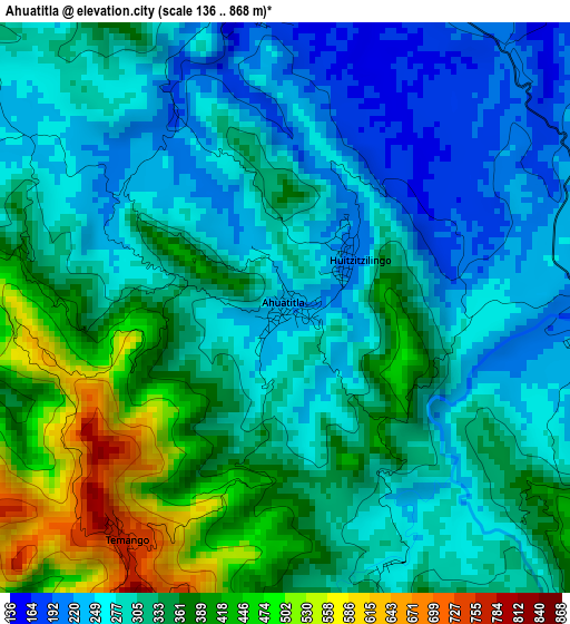
Below is the Elevation map of Ahuatitla, which displays elevation range with different colors. Scale of the first map is from 136 to 868 m (446 to 2848 ft) with average elevation of 320.4 meters (=1051 ft) [note 1]
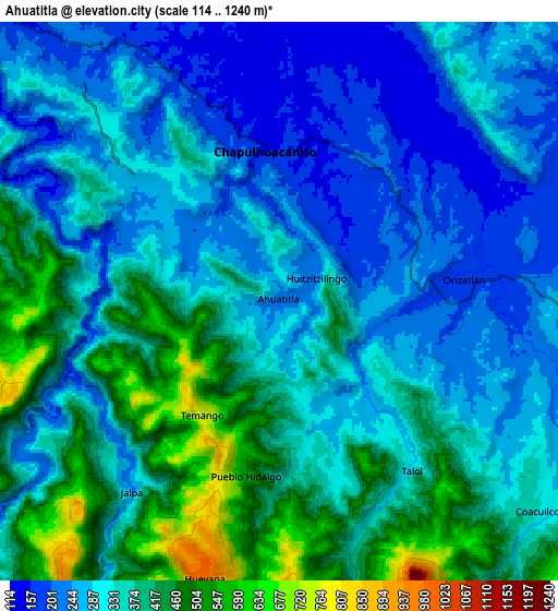
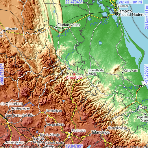
These maps also provides idea of topography and contour of this city, they are displayed at different zoom levels. More info about maps, scale and edge coordinates you can find below images.
| \ | Map #1 | Map #2 | Topo.Map |
| Scale [m] | 136..868 m | 114..1240 m | × |
| Scale [ft] | 446..2848 ft | 374..4068 ft | × |
| Average | 320.4 m = 1051 ft | 333.4 m = 1094 ft | × |
| Width | 9.11 km = 5.7 mi | 18.23 km = 11.3 mi | 291.6 km = 181.2 mi |
| Height | 9.11 km = 5.7 mi | 18.23 km = 11.3 mi | 291.6 km = 181.2 mi |
| ↑Max Latitude | 21.205925° | 21.246889° | 22.47043° |
| Latitude at center | 21.16495° | 21.16495° | 21.16495° |
| ↓Min Latitude | 21.123963° | 21.082965° | 19.84785° |
| ← Min Longitude | -98.709885° | -98.753831° | -100.07219° |
| Longitude center | -98.66594° | -98.66594° | -98.66594° |
| →Max Longitude | -98.621995° | -98.578049° | -97.25969° |
Nearby cities:
Cities around Ahuatitla sort by population:
• San Felipe Orizatlán elevation 178 m
6.1 km,  83°
83°
• Huitzitzilingo 213 m
1.3 km,  46°
46°
• Coacuilco 344 m
10.7 km,  129°
129°
• Chapulhuacanito 148 m
4.9 km,  354°
354°
• Acoyotla 881 m
12.4 km,  249°
249°
• Hueyapa 989 m
9.2 km,  194°
194°
• Jalpa 250 m
7.9 km,  218°
218°
• Talol 308 m
6.4 km,  140°
140°
• Pueblo Hidalgo 603 m
5.8 km, 192°
• Cuapaxtitla 243 m
12.3 km,  106°
106°
• San José 431 m
13 km,  145°
145°
• Temango 756 m
4.5 km,  214°
214°
Multilingual:
 En español:
Ahuatitla elevación 227 m.
 En France:
Ahuatitla élévation 227 m.
 Auf Deutsch:
Ahuatitla höhe über dem Meeresspiegel ist 227 m.

Sources and notes:
- [note 1] Map square and city borders are not equal. Map elevation data is calculated only from area inside that square.
- [src 1] Elevation data from geonames database provided with same terms of usage.
- [src 2] The elevation map of Ahuatitla is generated using elevation data from NASA's 3 arcsec (90m) resolution SRTM data.
- [src 3] Base (background) map © OpenStreetMap contributors tiles are generated by Geofabrik and OpenTopoMap.
Copyright & License:
This Ahuatitla Elevation Map is licensed under CC BY-SA. You may reuse any part from this page, if you give a proper credit by linking to this URL:
 More info on terms of use page.