Akil elevation
Akil (Yucatán), Mexico elevation is 29 meters and Akil elevation in feet is 95 ft above sea level [src 1]. Akil is a populated place (feature code) with elevation that is 1285 meters (4216 ft) smaller than average city elevation in Mexico.
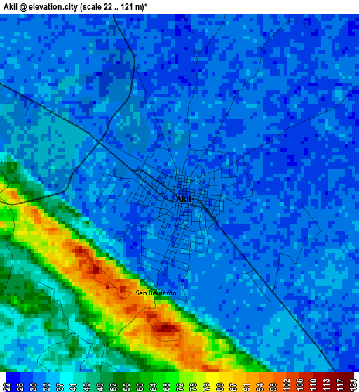
Below is the Elevation map of Akil, which displays elevation range with different colors. Scale of the first map is from 22 to 121 m (72 to 397 ft) with average elevation of 38.6 meters (=127 ft) [note 1]
These maps also provides idea of topography and contour of this city, they are displayed at different zoom levels. More info about maps, scale and edge coordinates you can find below images.
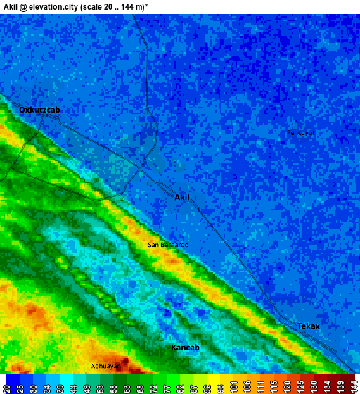
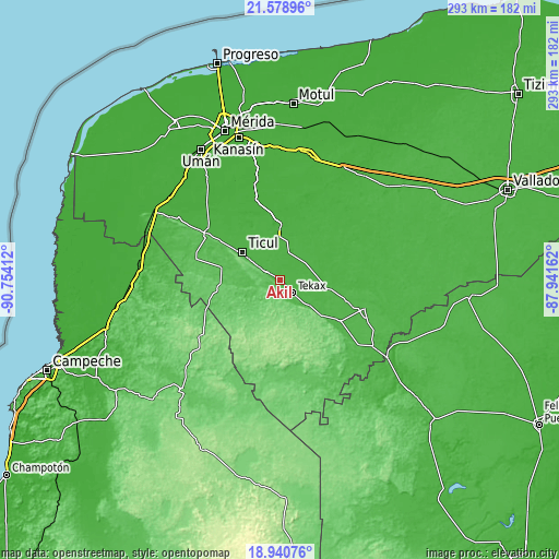
| \ | Map #1 | Map #2 | Topo.Map |
| Scale [m] | 22..121 m | 20..144 m | × |
| Scale [ft] | 72..397 ft | 66..472 ft | × |
| Average | 38.6 m = 127 ft | 43.3 m = 142 ft | × |
| Width | 9.17 km = 5.7 mi | 18.34 km = 11.4 mi | 293.3 km = 182.2 mi |
| Height | 9.17 km = 5.7 mi | 18.34 km = 11.4 mi | 293.4 km = 182.3 mi |
| ↑Max Latitude | 20.30669° | 20.347898° | 21.57896° |
| Latitude at center | 20.26547° | 20.26547° | 20.26547° |
| ↓Min Latitude | 20.22424° | 20.182998° | 18.94076° |
| ← Min Longitude | -89.391815° | -89.435761° | -90.75412° |
| Longitude center | -89.34787° | -89.34787° | -89.34787° |
| →Max Longitude | -89.303925° | -89.259979° | -87.94162° |
Nearby cities:
Cities around Akil sort by population:
• Tecax elevation 37 m
9.4 km,  135°
135°
• Oxkutzkab 23 m
8.7 km,  302°
302°
• Teabo 22 m
16.5 km,  24°
24°
• Dzan 31 m
18.6 km,  317°
317°
• Mani 32 m
14.3 km,  341°
341°
• Chumayel 29 m
18.8 km, 15°
• Kancab 38 m
7.8 km,  178°
178°
• Yotholin 32 m
13.1 km, 302°
• Xaya 31 m
17.2 km,  78°
78°
• Pencuyut 31 m
6.9 km,  62°
62°
• Xohuayan 115 m
9.4 km,  203°
203°
• Emiliano Zapata 57 m
13.3 km,  250°
250°
Multilingual:
 En español:
Akil elevación 29 m.
 En France:
Akil élévation 29 m.


Sources and notes:
- [note 1] Map square and city borders are not equal. Map elevation data is calculated only from area inside that square.
- [src 1] Elevation data from geonames database provided with same terms of usage.
- [src 2] The elevation map of Akil is generated using elevation data from NASA's 3 arcsec (90m) resolution SRTM data.
- [src 3] Base (background) map © OpenStreetMap contributors tiles are generated by Geofabrik and OpenTopoMap.
Copyright & License:
This Akil Elevation Map is licensed under CC BY-SA. You may reuse any part from this page, if you give a proper credit by linking to this URL:
 More info on terms of use page.