Amayuca elevation
Amayuca (Morelos, Jantetelco), Mexico elevation is 1442 meters and Amayuca elevation in feet is 4731 ft above sea level [src 1]. Amayuca is a populated place (feature code) with elevation that is 128 meters (420 ft) bigger than average city elevation in Mexico.
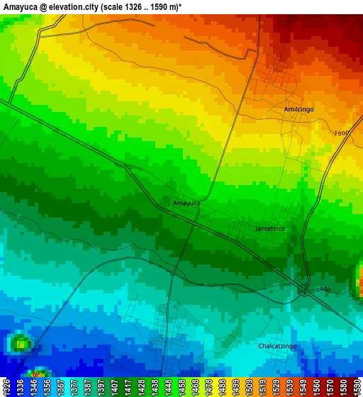
Below is the Elevation map of Amayuca, which displays elevation range with different colors. Scale of the first map is from 1326 to 1590 m (4350 to 5217 ft) with average elevation of 1438.9 meters (=4721 ft) [note 1]
These maps also provides idea of topography and contour of this city, they are displayed at different zoom levels. More info about maps, scale and edge coordinates you can find below images.
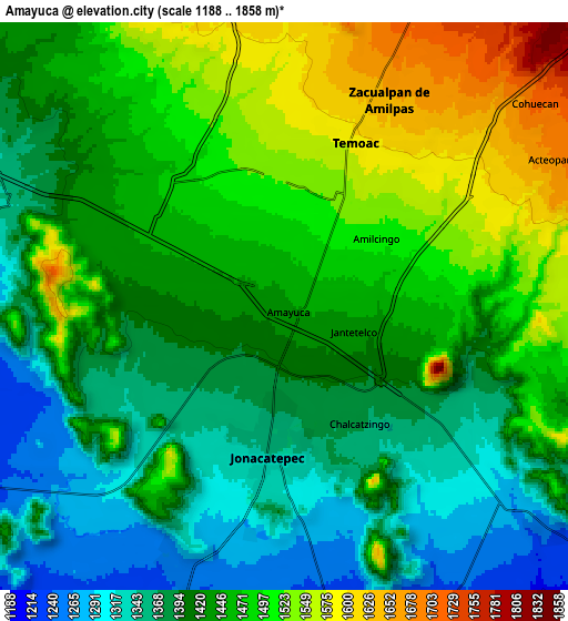
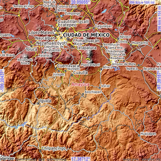
| \ | Map #1 | Map #2 | Topo.Map |
| Scale [m] | 1326..1590 m | 1188..1858 m | × |
| Scale [ft] | 4350..5217 ft | 3898..6096 ft | × |
| Average | 1438.9 m = 4721 ft | 1440.9 m = 4727 ft | × |
| Width | 9.26 km = 5.8 mi | 18.51 km = 11.5 mi | 296.1 km = 184 mi |
| Height | 9.26 km = 5.8 mi | 18.51 km = 11.5 mi | 296.2 km = 184 mi |
| ↑Max Latitude | 18.765694° | 18.807299° | 20.05055° |
| Latitude at center | 18.72408° | 18.72408° | 18.72408° |
| ↓Min Latitude | 18.682455° | 18.64082° | 17.38712° |
| ← Min Longitude | -98.842065° | -98.886011° | -100.20437° |
| Longitude center | -98.79812° | -98.79812° | -98.79812° |
| →Max Longitude | -98.754175° | -98.710229° | -97.39187° |
Nearby cities:
Cities around Amayuca sort by population:
• Jonacatepec elevation 1343 m
4.8 km,  186°
186°
• Temoac 1588 m
5.8 km,  22°
22°
• Jantetelco 1439 m
2.3 km,  106°
106°
• Huazulco 1546 m
4 km,  36°
36°
• Amilcingo 1507 m
3.5 km,  54°
54°
• Zacualpan de Amilpas 1649 m
7.5 km,  27°
27°
• Atotonilco 1251 m
9 km,  202°
202°
• Chalcatzingo 1372 m
4.6 km,  146°
146°
• Amacuitlapilco 1368 m
3.4 km, 204°
• Acteopan 1666 m
9.9 km,  63°
63°
• Tecajec 1584 m
8.4 km,  347°
347°
• Unidad Habitacional Mariano Matamoros 1435 m
6.3 km,  294°
294°
Multilingual:
 En español:
Amayuca elevación 1442 m.
 En France:
Amayuca élévation 1442 m.
 Auf Deutsch:
Amayuca höhe über dem Meeresspiegel ist 1442 m.

Sources and notes:
- [note 1] Map square and city borders are not equal. Map elevation data is calculated only from area inside that square.
- [src 1] Elevation data from geonames database provided with same terms of usage.
- [src 2] The elevation map of Amayuca is generated using elevation data from NASA's 3 arcsec (90m) resolution SRTM data.
- [src 3] Base (background) map © OpenStreetMap contributors tiles are generated by Geofabrik and OpenTopoMap.
Copyright & License:
This Amayuca Elevation Map is licensed under CC BY-SA. You may reuse any part from this page, if you give a proper credit by linking to this URL:
 More info on terms of use page.