Anáhuac elevation
Anáhuac (Tamaulipas, Valle Hermoso), Mexico elevation is 18 meters and Anáhuac elevation in feet is 59 ft above sea level [src 1]. Anáhuac is a populated place (feature code) with elevation that is 1296 meters (4252 ft) smaller than average city elevation in Mexico.
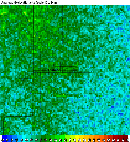
Below is the Elevation map of Anáhuac, which displays elevation range with different colors. Scale of the first map is from 10 to 24 m (33 to 79 ft) with average elevation of 16.5 meters (=54 ft) [note 1]
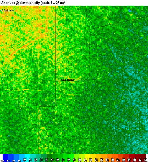
These maps also provides idea of topography and contour of this city, they are displayed at different zoom levels. More info about maps, scale and edge coordinates you can find below images.
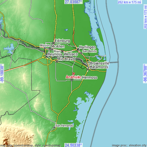
| \ | Map #1 | Map #2 | Topo.Map |
| Scale [m] | 10..24 m | 6..27 m | × |
| Scale [ft] | 33..79 ft | 20..89 ft | × |
| Average | 16.5 m = 54 ft | 16.3 m = 53 ft | × |
| Width | 8.8 km = 5.5 mi | 17.6 km = 10.9 mi | 281.6 km = 175 mi |
| Height | 8.8 km = 5.5 mi | 17.6 km = 10.9 mi | 281.6 km = 175 mi |
| ↑Max Latitude | 25.815946° | 25.855499° | 27.03587° |
| Latitude at center | 25.77638° | 25.77638° | 25.77638° |
| ↓Min Latitude | 25.736801° | 25.697208° | 24.50338° |
| ← Min Longitude | -97.818075° | -97.862021° | -99.18038° |
| Longitude center | -97.77413° | -97.77413° | -97.77413° |
| →Max Longitude | -97.730185° | -97.686239° | -96.36788° |
Nearby cities:
Cities around Anáhuac sort by population:
• Heroica Matamoros elevation 16 m
29.4 km,  66°
66°
• Ciudad Río Bravo 36 m
39.7 km,  306°
306°
• Valle Hermoso 20 m
12.2 km,  198°
198°
• Nuevo Progreso 28 m
35.8 km,  330°
330°
• Ramírez 20 m
19.5 km,  356°
356°
• El Realito 20 m
16 km,  219°
219°
• El Control 24 m
20.6 km,  349°
349°
• CEFERESO Número 3 14 m
16.1 km,  60°
60°
• Vamos Tamaulipas 41 m
50.5 km,  297°
297°
• Santa Adelaida 15 m
15 km,  54°
54°
• Santa Apolonia 20 m
25.8 km,  234°
234°
• El Galaneño 14 m
23 km,  94°
94°
Multilingual:
 En español:
Anáhuac elevación 18 m.
 En France:
Anáhuac élévation 18 m.


Sources and notes:
- [note 1] Map square and city borders are not equal. Map elevation data is calculated only from area inside that square.
- [src 1] Elevation data from geonames database provided with same terms of usage.
- [src 2] The elevation map of Anáhuac is generated using elevation data from NASA's 3 arcsec (90m) resolution SRTM data.
- [src 3] Base (background) map © OpenStreetMap contributors tiles are generated by Geofabrik and OpenTopoMap.
Copyright & License:
This Anáhuac Elevation Map is licensed under CC BY-SA. You may reuse any part from this page, if you give a proper credit by linking to this URL:
 More info on terms of use page.