Ángel R. Cabada elevation
Ángel R. Cabada (Veracruz, Angel R. Cabada), Mexico elevation is 30 meters and Ángel R. Cabada elevation in feet is 98 ft above sea level [src 1]. Ángel R. Cabada is a seat of a second-order administrative division (feature code) with elevation that is 1284 meters (4213 ft) smaller than average city elevation in Mexico.
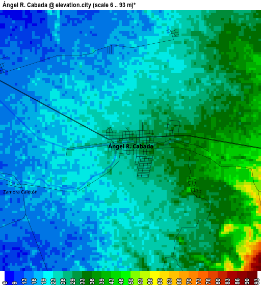
Below is the Elevation map of Ángel R. Cabada, which displays elevation range with different colors. Scale of the first map is from 6 to 93 m (20 to 305 ft) with average elevation of 24.9 meters (=82 ft) [note 1]
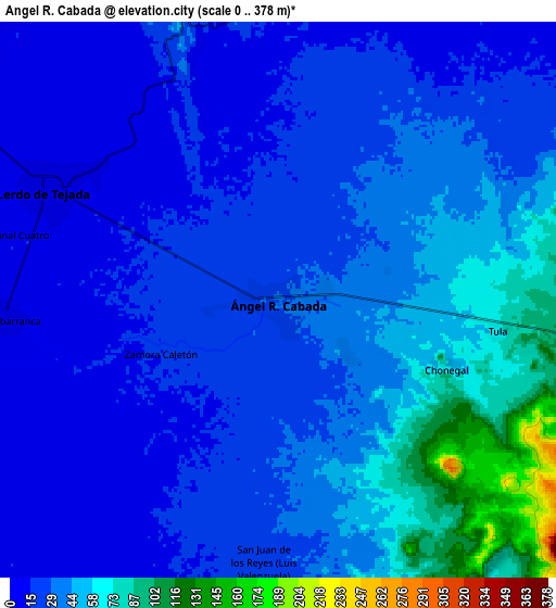
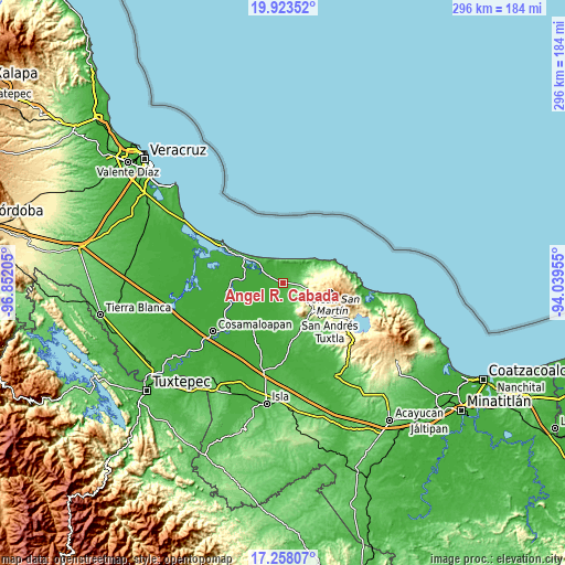
These maps also provides idea of topography and contour of this city, they are displayed at different zoom levels. More info about maps, scale and edge coordinates you can find below images.
| \ | Map #1 | Map #2 | Topo.Map |
| Scale [m] | 6..93 m | 0..378 m | × |
| Scale [ft] | 20..305 ft | 0..1240 ft | × |
| Average | 24.9 m = 82 ft | 34.3 m = 113 ft | × |
| Width | 9.26 km = 5.8 mi | 18.52 km = 11.5 mi | 296.4 km = 184.2 mi |
| Height | 9.26 km = 5.8 mi | 18.52 km = 11.5 mi | 296.4 km = 184.2 mi |
| ↑Max Latitude | 18.637656° | 18.679292° | 19.92352° |
| Latitude at center | 18.59601° | 18.59601° | 18.59601° |
| ↓Min Latitude | 18.554354° | 18.512688° | 17.25807° |
| ← Min Longitude | -95.489745° | -95.533691° | -96.85205° |
| Longitude center | -95.4458° | -95.4458° | -95.4458° |
| →Max Longitude | -95.401855° | -95.357909° | -94.03955° |
Nearby cities:
Cities around Ángel R. Cabada sort by population:
• Lerdo de Tejada elevation 9 m
8.6 km,  295°
295°
• Tres Zapotes 29 m
14.2 km,  176°
176°
• Saltabarranca 7 m
9.1 km,  266°
266°
• Tlapacoyan 39 m
16.2 km,  162°
162°
• Tapalapan 283 m
16.3 km,  115°
115°
• Tecolapan 160 m
11.5 km,  104°
104°
• San Juan de los Reyes (Luis Valenzuela) 26 m
8.7 km, 182°
• Tula 70 m
7.3 km, 98°
• Los Lirios 50 m
12.2 km,  150°
150°
• Chonegal 68 m
6 km,  112°
112°
• Zamora 17 m
4.3 km,  247°
247°
• Arroyo San Isidro 50 m
12.6 km, 164°
Multilingual:
 En español:
Angel R. Cabadas elevación 30 m.
 En France:
Ángel R. Cabada élévation 30 m.
 Auf Deutsch:
Ángel R. Cabada höhe über dem Meeresspiegel ist 30 m.

Sources and notes:
- [note 1] Map square and city borders are not equal. Map elevation data is calculated only from area inside that square.
- [src 1] Elevation data from geonames database provided with same terms of usage.
- [src 2] The elevation map of Ángel R. Cabada is generated using elevation data from NASA's 3 arcsec (90m) resolution SRTM data.
- [src 3] Base (background) map © OpenStreetMap contributors tiles are generated by Geofabrik and OpenTopoMap.
Copyright & License:
This Ángel R. Cabada Elevation Map is licensed under CC BY-SA. You may reuse any part from this page, if you give a proper credit by linking to this URL:
 More info on terms of use page.