Asunción Nochixtlán elevation
Asunción Nochixtlán (Oaxaca), Mexico elevation is 2080 meters and Asunción Nochixtlán elevation in feet is 6824 ft above sea level [src 1]. Asunción Nochixtlán is a seat of a second-order administrative division (feature code) with elevation that is 766 meters (2513 ft) bigger than average city elevation in Mexico.
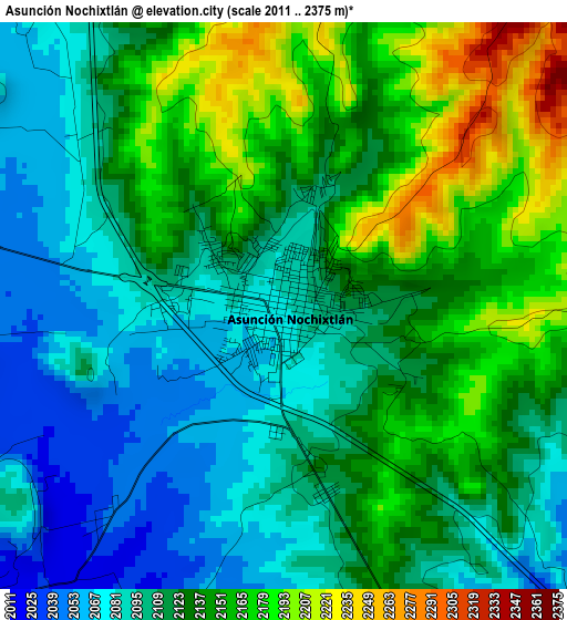
Below is the Elevation map of Asunción Nochixtlán, which displays elevation range with different colors. Scale of the first map is from 2011 to 2375 m (6598 to 7792 ft) with average elevation of 2123.1 meters (=6966 ft) [note 1]
These maps also provides idea of topography and contour of this city, they are displayed at different zoom levels. More info about maps, scale and edge coordinates you can find below images.
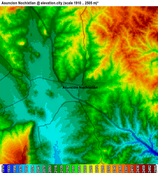
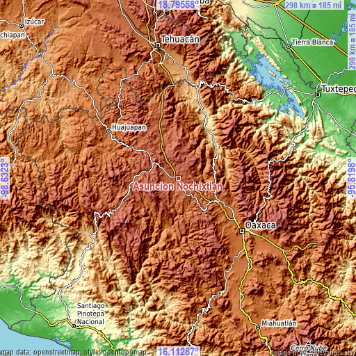
| \ | Map #1 | Map #2 | Topo.Map |
| Scale [m] | 2011..2375 m | 1910..2505 m | × |
| Scale [ft] | 6598..7792 ft | 6266..8219 ft | × |
| Average | 2123.1 m = 6966 ft | 2163.3 m = 7097 ft | × |
| Width | 9.32 km = 5.8 mi | 18.64 km = 11.6 mi | 298.3 km = 185.4 mi |
| Height | 9.32 km = 5.8 mi | 18.64 km = 11.6 mi | 298.3 km = 185.4 mi |
| ↑Max Latitude | 17.501076° | 17.542982° | 18.79558° |
| Latitude at center | 17.45916° | 17.45916° | 17.45916° |
| ↓Min Latitude | 17.417234° | 17.375299° | 16.11287° |
| ← Min Longitude | -97.269995° | -97.313941° | -98.6323° |
| Longitude center | -97.22605° | -97.22605° | -97.22605° |
| →Max Longitude | -97.182105° | -97.138159° | -95.8198° |
Nearby cities:
Cities around Asunción Nochixtlán sort by population:
• San Francisco Chindúa elevation 2126 m
9.8 km,  249°
249°
• San Andrés Sinaxtla 2099 m
6.1 km,  280°
280°
• Yucuita 2081 m
7.4 km,  321°
321°
• San Juan Sayultepec 2102 m
6.3 km,  263°
263°
• Santa María Chachoápam 2106 m
9.6 km, 320°
• San Mateo Etlatongo 2046 m
7 km,  226°
226°
• Santiago Tillo 2091 m
10 km,  271°
271°
• Magdalena Zahuatlán 2123 m
7.7 km,  181°
181°
• San Francisco Jaltepetongo 2087 m
9.1 km,  206°
206°
• San Miguel Tecomatlán 2097 m
8.5 km, 212°
• San Pedro Coxcaltepec Cántaros 2264 m
10.3 km,  64°
64°
• San Pedro Topiltepec 2162 m
12.8 km, 258°
Multilingual:
 En español:
Asunción Nochixtlán elevación 2080 m.
 En France:
Asunción Nochixtlán élévation 2080 m.
 Auf Deutsch:
Asunción Nochixtlán höhe über dem Meeresspiegel ist 2080 m.
 На русском:
Asunción Nochixtlán высота над уровнем моря 2080 м
Sources and notes:
- [note 1] Map square and city borders are not equal. Map elevation data is calculated only from area inside that square.
- [src 1] Elevation data from geonames database provided with same terms of usage.
- [src 2] The elevation map of Asunción Nochixtlán is generated using elevation data from NASA's 3 arcsec (90m) resolution SRTM data.
- [src 3] Base (background) map © OpenStreetMap contributors tiles are generated by Geofabrik and OpenTopoMap.
Copyright & License:
This Asunción Nochixtlán Elevation Map is licensed under CC BY-SA. You may reuse any part from this page, if you give a proper credit by linking to this URL:
 More info on terms of use page.