Soledad Atzompa elevation
Soledad Atzompa (Veracruz), Mexico elevation is 2329 meters and Soledad Atzompa elevation in feet is 7641 ft above sea level [src 1]. Soledad Atzompa is a populated place (feature code) with elevation that is 1015 meters (3330 ft) bigger than average city elevation in Mexico.
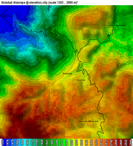
Below is the Elevation map of Soledad Atzompa, which displays elevation range with different colors. Scale of the first map is from 1353 to 2995 m (4439 to 9826 ft) with average elevation of 2271 meters (=7451 ft) [note 1]
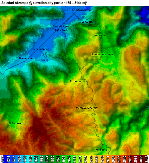
These maps also provides idea of topography and contour of this city, they are displayed at different zoom levels. More info about maps, scale and edge coordinates you can find below images.
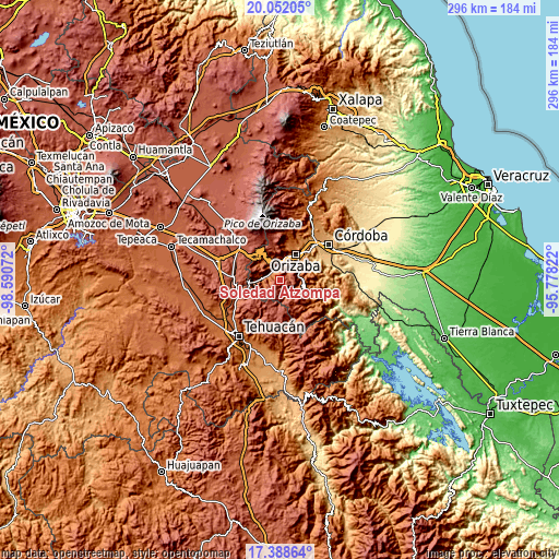
| \ | Map #1 | Map #2 | Topo.Map |
| Scale [m] | 1353..2995 m | 1165..3144 m | × |
| Scale [ft] | 4439..9826 ft | 3822..10315 ft | × |
| Average | 2271 m = 7451 ft | 2159.3 m = 7084 ft | × |
| Width | 9.26 km = 5.8 mi | 18.51 km = 11.5 mi | 296.1 km = 184 mi |
| Height | 9.26 km = 5.8 mi | 18.51 km = 11.5 mi | 296.2 km = 184 mi |
| ↑Max Latitude | 18.767204° | 18.808808° | 20.05205° |
| Latitude at center | 18.72559° | 18.72559° | 18.72559° |
| ↓Min Latitude | 18.683966° | 18.642331° | 17.38864° |
| ← Min Longitude | -97.228415° | -97.272361° | -98.59072° |
| Longitude center | -97.18447° | -97.18447° | -97.18447° |
| →Max Longitude | -97.140525° | -97.096579° | -95.77822° |
Nearby cities:
Cities around Soledad Atzompa sort by population:
• Necoxtla elevation 2047 m
6.7 km,  28°
28°
• Tecamalucan 1380 m
5.8 km,  312°
312°
• La Cuesta 1666 m
7.4 km,  13°
13°
• Mexcala 2364 m
3.9 km,  148°
148°
• Taza de Agua Ojo Zarco 1342 m
6.7 km,  343°
343°
• Acatla 1439 m
4.4 km, 306°
• Huitzila 2332 m
1.7 km,  116°
116°
• Sierra de Agua 1399 m
6.6 km,  294°
294°
• Tlatilpa 2225 m
4.3 km,  77°
77°
• Tlatzala 2262 m
4.6 km,  85°
85°
• Tetlatzinga 2611 m
3.4 km,  179°
179°
• Soledad Atzompa 2108 m
4.9 km,  47°
47°
Multilingual:
 En español:
Soledad Atzompa elevación 2329 m.
 En France:
Soledad Atzompa élévation 2329 m.
 Auf Deutsch:
Soledad Atzompa höhe über dem Meeresspiegel ist 2329 m.

Sources and notes:
- [note 1] Map square and city borders are not equal. Map elevation data is calculated only from area inside that square.
- [src 1] Elevation data from geonames database provided with same terms of usage.
- [src 2] The elevation map of Soledad Atzompa is generated using elevation data from NASA's 3 arcsec (90m) resolution SRTM data.
- [src 3] Base (background) map © OpenStreetMap contributors tiles are generated by Geofabrik and OpenTopoMap.
Copyright & License:
This Soledad Atzompa Elevation Map is licensed under CC BY-SA. You may reuse any part from this page, if you give a proper credit by linking to this URL:
 More info on terms of use page.