Axapusco elevation
Axapusco (State of Mexico), Mexico elevation is 2351 meters and Axapusco elevation in feet is 7713 ft above sea level [src 1]. Axapusco is a seat of a second-order administrative division (feature code) with elevation that is 1037 meters (3402 ft) bigger than average city elevation in Mexico.
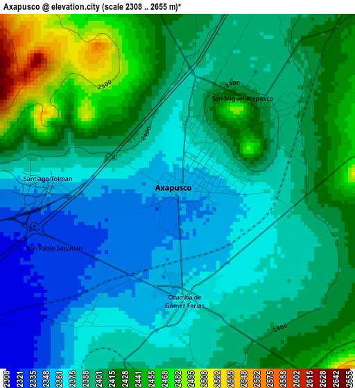
Below is the Elevation map of Axapusco, which displays elevation range with different colors. Scale of the first map is from 2308 to 2655 m (7572 to 8711 ft) with average elevation of 2396.8 meters (=7864 ft) [note 1]
These maps also provides idea of topography and contour of this city, they are displayed at different zoom levels. More info about maps, scale and edge coordinates you can find below images.
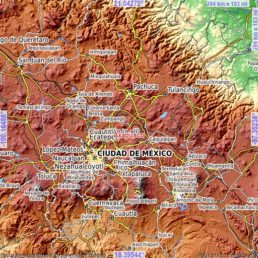
| \ | Map #1 | Topo.Map |
| Scale [m] | 2308..2655 m | × |
| Scale [ft] | 7572..8711 ft | × |
| Average | 2396.8 m = 7864 ft | × |
| Width | 9.2 km = 5.7 mi | 294.3 km = 182.9 mi |
| Height | 9.2 km = 5.7 mi | 294.4 km = 182.9 mi |
| ↑Max Latitude | 19.765922° | 21.04272° |
| Latitude at center | 19.72456° | 19.72456° |
| ↓Min Latitude | 19.683188° | 18.39544° |
| ← Min Longitude | -98.802575° | -100.16488° |
| Longitude center | -98.75863° | -98.75863° |
| →Max Longitude | -98.714685° | -97.35238° |
Nearby cities:
Cities around Axapusco sort by population:
• San Martín de las Pirámides elevation 2311 m
8.3 km,  255°
255°
• Otumba 2367 m
2.8 km,  175°
175°
• Santiago Tolman 2364 m
3.3 km,  276°
276°
• Nopaltepec 2451 m
7.8 km,  40°
40°
• Cuautlacingo 2359 m
4.3 km,  217°
217°
• Oxtotipac 2380 m
8.5 km,  205°
205°
• Santo Domingo Aztacameca 2477 m
6.5 km,  351°
351°
• San Francisco Tlaltica 2401 m
7.6 km,  193°
193°
• San Pablo Ixquitlán 2328 m
3.5 km,  241°
241°
• San Martín Ahuatepec 2443 m
5.8 km,  146°
146°
• San Miguel Atepoxco 2415 m
3 km, 40°
• Colonia los Remedios 2409 m
3.6 km,  287°
287°
Multilingual:
 En español:
Axapusco elevación 2351 m.
 En France:
Axapusco élévation 2351 m.
 Auf Deutsch:
Axapusco höhe über dem Meeresspiegel ist 2351 m.

Sources and notes:
- [note 1] Map square and city borders are not equal. Map elevation data is calculated only from area inside that square.
- [src 1] Elevation data from geonames database provided with same terms of usage.
- [src 2] The elevation map of Axapusco is generated using elevation data from NASA's 3 arcsec (90m) resolution SRTM data.
- [src 3] Base (background) map © OpenStreetMap contributors tiles are generated by Geofabrik and OpenTopoMap.
Copyright & License:
This Axapusco Elevation Map is licensed under CC BY-SA. You may reuse any part from this page, if you give a proper credit by linking to this URL:
 More info on terms of use page.