Ayahualulco elevation
Ayahualulco (Guerrero, Chilapa de Álvarez), Mexico elevation is 1425 meters and Ayahualulco elevation in feet is 4675 ft above sea level [src 1]. Ayahualulco is a populated place (feature code) with elevation that is 111 meters (364 ft) bigger than average city elevation in Mexico.
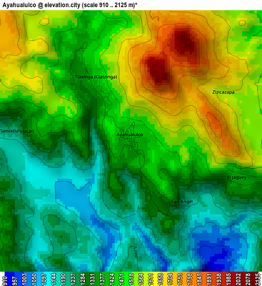
Below is the Elevation map of Ayahualulco, which displays elevation range with different colors. Scale of the first map is from 910 to 2125 m (2986 to 6972 ft) with average elevation of 1412.5 meters (=4634 ft) [note 1]
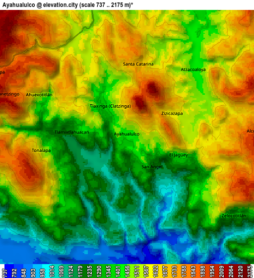
These maps also provides idea of topography and contour of this city, they are displayed at different zoom levels. More info about maps, scale and edge coordinates you can find below images.
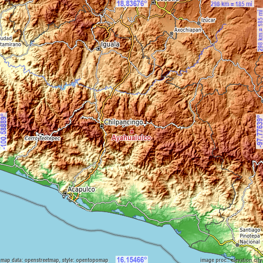
| \ | Map #1 | Map #2 | Topo.Map |
| Scale [m] | 910..2125 m | 737..2175 m | × |
| Scale [ft] | 2986..6972 ft | 2418..7136 ft | × |
| Average | 1412.5 m = 4634 ft | 1449.1 m = 4754 ft | × |
| Width | 9.32 km = 5.8 mi | 18.64 km = 11.6 mi | 298.2 km = 185.3 mi |
| Height | 9.32 km = 5.8 mi | 18.64 km = 11.6 mi | 298.2 km = 185.3 mi |
| ↑Max Latitude | 17.542566° | 17.584463° | 18.83676° |
| Latitude at center | 17.50066° | 17.50066° | 17.50066° |
| ↓Min Latitude | 17.458744° | 17.416818° | 16.15466° |
| ← Min Longitude | -99.226585° | -99.270531° | -100.58889° |
| Longitude center | -99.18264° | -99.18264° | -99.18264° |
| →Max Longitude | -99.138695° | -99.094749° | -97.77639° |
Nearby cities:
Cities around Ayahualulco sort by population:
• Tlamixtlahuacan elevation 1218 m
4.6 km,  273°
273°
• Atzacoaloya 1424 m
7 km,  43°
43°
• Santa Catarina 1699 m
5.4 km,  8°
8°
• Tlaxinga (Clatzinga) 1466 m
2.5 km,  333°
333°
• Atenxoxola 1424 m
4.4 km,  108°
108°
• Tlacoaxtla 1583 m
6.3 km,  342°
342°
• Zizicazapa 1582 m
3.6 km,  62°
62°
• San Ángel 1245 m
2.8 km,  139°
139°
• Ahuexotitlán 1545 m
7.2 km,  295°
295°
• Acalco 1609 m
1.8 km,  71°
71°
• Cuauhtenango 1594 m
5.7 km, 333°
• Tonalapa 1525 m
6.4 km,  259°
259°
Multilingual:
 En español:
Ayahualulco elevación 1425 m.
 En France:
Ayahualulco élévation 1425 m.
 Auf Deutsch:
Ayahualulco höhe über dem Meeresspiegel ist 1425 m.

Sources and notes:
- [note 1] Map square and city borders are not equal. Map elevation data is calculated only from area inside that square.
- [src 1] Elevation data from geonames database provided with same terms of usage.
- [src 2] The elevation map of Ayahualulco is generated using elevation data from NASA's 3 arcsec (90m) resolution SRTM data.
- [src 3] Base (background) map © OpenStreetMap contributors tiles are generated by Geofabrik and OpenTopoMap.
Copyright & License:
This Ayahualulco Elevation Map is licensed under CC BY-SA. You may reuse any part from this page, if you give a proper credit by linking to this URL:
 More info on terms of use page.