Bacalar elevation
Bacalar (Quintana Roo, Othón P. Blanco), Mexico elevation is 17 meters and Bacalar elevation in feet is 56 ft above sea level [src 1]. Bacalar is a populated place (feature code) with elevation that is 1297 meters (4255 ft) smaller than average city elevation in Mexico.
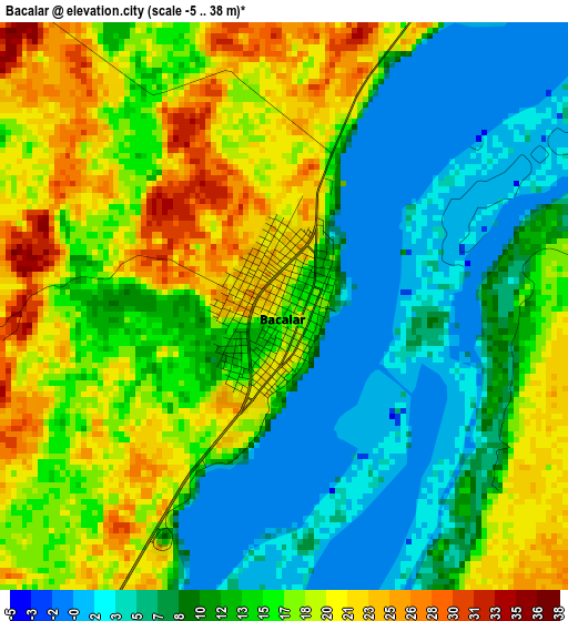
Below is the Elevation map of Bacalar, which displays elevation range with different colors. Scale of the first map is from -5 to 38 m (-16 to 125 ft) with average elevation of 13.2 meters (=43 ft) [note 1]
These maps also provides idea of topography and contour of this city, they are displayed at different zoom levels. More info about maps, scale and edge coordinates you can find below images.
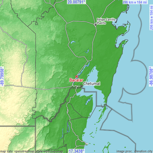
| \ | Map #1 | Map #2 | Topo.Map |
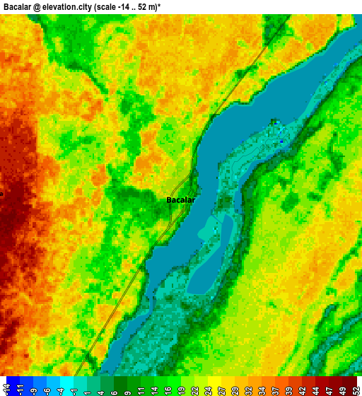
| Scale [m] | -5..38 m | -14..52 m | × |
| Scale [ft] | -16..125 ft | -46..171 ft | × |
| Average | 13.2 m = 43 ft | 20.3 m = 67 ft | × |
| Width | 9.26 km = 5.8 mi | 18.52 km = 11.5 mi | 296.2 km = 184 mi |
| Height | 9.26 km = 5.8 mi | 18.52 km = 11.5 mi | 296.2 km = 184 mi |
| ↑Max Latitude | 18.722715° | 18.76433° | 20.00791° |
| Latitude at center | 18.68109° | 18.68109° | 18.68109° |
| ↓Min Latitude | 18.639455° | 18.597809° | 17.3438° |
| ← Min Longitude | -88.437275° | -88.481221° | -89.79958° |
| Longitude center | -88.39333° | -88.39333° | -88.39333° |
| →Max Longitude | -88.349385° | -88.305439° | -86.98708° |
Nearby cities:
Cities around Bacalar sort by population:
• Chetumal elevation 9 m
20.8 km,  153°
153°
• Calderitas 13 m
20.2 km,  133°
133°
• Sergio Butrón Casas 38 m
26.2 km,  224°
224°
• Xul-Ha 24 m
16.2 km,  207°
207°
• Maya Balam 23 m
28.7 km,  358°
358°
• Subteniente López 5 m
20.6 km,  179°
179°
• Carlos A. Madrazo 26 m
24.3 km, 214°
• Huay-Pix 4 m
18.6 km,  190°
190°
• Ucum 29 m
23.8 km, 213°
• Sabidos 55 m
41.4 km, 209°
• Los Divorciados 38 m
44.5 km,  351°
351°
• Juan Sarabia 31 m
22.1 km,  204°
204°
Multilingual:
 En español:
Bacalar elevación 17 m.
 En France:
Bacalar élévation 17 m.


Sources and notes:
- [note 1] Map square and city borders are not equal. Map elevation data is calculated only from area inside that square.
- [src 1] Elevation data from geonames database provided with same terms of usage.
- [src 2] The elevation map of Bacalar is generated using elevation data from NASA's 3 arcsec (90m) resolution SRTM data.
- [src 3] Base (background) map © OpenStreetMap contributors tiles are generated by Geofabrik and OpenTopoMap.
Copyright & License:
This Bacalar Elevation Map is licensed under CC BY-SA. You may reuse any part from this page, if you give a proper credit by linking to this URL:
 More info on terms of use page.