Cacahoatán elevation
Cacahoatán (Chiapas), Mexico elevation is 498 meters and Cacahoatán elevation in feet is 1634 ft above sea level [src 1]. Cacahoatán is a seat of a second-order administrative division (feature code) with elevation that is 816 meters (2677 ft) smaller than average city elevation in Mexico.
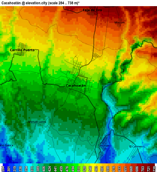
Below is the Elevation map of Cacahoatán, which displays elevation range with different colors. Scale of the first map is from 284 to 738 m (932 to 2421 ft) with average elevation of 497.3 meters (=1632 ft) [note 1]
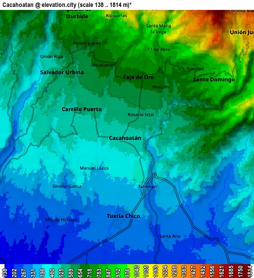
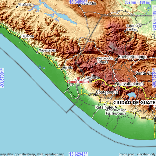
These maps also provides idea of topography and contour of this city, they are displayed at different zoom levels. More info about maps, scale and edge coordinates you can find below images.
| \ | Map #1 | Map #2 | Topo.Map |
| Scale [m] | 284..738 m | 138..1814 m | × |
| Scale [ft] | 932..2421 ft | 453..5951 ft | × |
| Average | 497.3 m = 1632 ft | 537 m = 1762 ft | × |
| Width | 9.44 km = 5.9 mi | 18.88 km = 11.7 mi | 302 km = 187.7 mi |
| Height | 9.44 km = 5.9 mi | 18.88 km = 11.7 mi | 302.1 km = 187.7 mi |
| ↑Max Latitude | 15.034455° | 15.076892° | 16.34596° |
| Latitude at center | 14.99201° | 14.99201° | 14.99201° |
| ↓Min Latitude | 14.949556° | 14.907094° | 13.62943° |
| ← Min Longitude | -92.207705° | -92.251651° | -93.57001° |
| Longitude center | -92.16376° | -92.16376° | -92.16376° |
| →Max Longitude | -92.119815° | -92.075869° | -90.75751° |
Nearby cities:
Cities around Cacahoatán sort by population:
• Tuxtla Chico elevation 321 m
5.9 km,  183°
183°
• Santo Domingo 870 m
7.8 km,  56°
56°
• Carrillo Puerto 538 m
4 km,  302°
302°
• Salvador Urbina 580 m
6.8 km,  315°
315°
• Faja de Oro 694 m
4.6 km,  10°
10°
• Manuel Lazos 399 m
3.4 km,  228°
228°
• Ahuacatlán 681 m
5.7 km,  341°
341°
• Mixcum 676 m
4.5 km,  33°
33°
• Benito Juárez 669 m
7.6 km, 337°
• 1ra. Sección de Izapa 279 m
8 km,  185°
185°
• Talismán 335 m
3.7 km,  150°
150°
• Once de Abril 825 m
7.1 km,  19°
19°
Multilingual:
 En español:
Cacahoatán elevación 498 m.
 En France:
Cacahoatán élévation 498 m.
 Auf Deutsch:
Cacahoatán höhe über dem Meeresspiegel ist 498 m.

Sources and notes:
- [note 1] Map square and city borders are not equal. Map elevation data is calculated only from area inside that square.
- [src 1] Elevation data from geonames database provided with same terms of usage.
- [src 2] The elevation map of Cacahoatán is generated using elevation data from NASA's 3 arcsec (90m) resolution SRTM data.
- [src 3] Base (background) map © OpenStreetMap contributors tiles are generated by Geofabrik and OpenTopoMap.
Copyright & License:
This Cacahoatán Elevation Map is licensed under CC BY-SA. You may reuse any part from this page, if you give a proper credit by linking to this URL:
 More info on terms of use page.