Cadereyta elevation
Cadereyta (Querétaro, Cadereyta de Montes), Mexico elevation is 2044 meters and Cadereyta elevation in feet is 6706 ft above sea level [src 1]. Cadereyta is a seat of a second-order administrative division (feature code) with elevation that is 730 meters (2395 ft) bigger than average city elevation in Mexico.
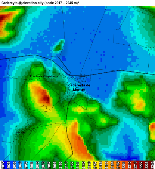
Below is the Elevation map of Cadereyta, which displays elevation range with different colors. Scale of the first map is from 2017 to 2245 m (6617 to 7365 ft) with average elevation of 2075.9 meters (=6811 ft) [note 1]
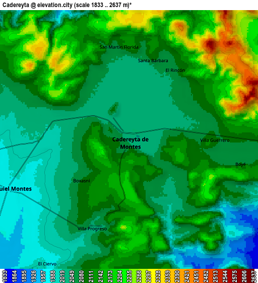
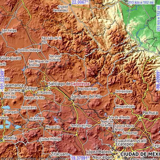
These maps also provides idea of topography and contour of this city, they are displayed at different zoom levels. More info about maps, scale and edge coordinates you can find below images.
| \ | Map #1 | Map #2 | Topo.Map |
| Scale [m] | 2017..2245 m | 1833..2637 m | × |
| Scale [ft] | 6617..7365 ft | 6014..8652 ft | × |
| Average | 2075.9 m = 6811 ft | 2099.9 m = 6889 ft | × |
| Width | 9.14 km = 5.7 mi | 18.28 km = 11.4 mi | 292.5 km = 181.8 mi |
| Height | 9.14 km = 5.7 mi | 18.28 km = 11.4 mi | 292.5 km = 181.8 mi |
| ↑Max Latitude | 20.738114° | 20.779206° | 22.0067° |
| Latitude at center | 20.69701° | 20.69701° | 20.69701° |
| ↓Min Latitude | 20.655895° | 20.614769° | 19.37591° |
| ← Min Longitude | -99.860185° | -99.904131° | -101.22249° |
| Longitude center | -99.81624° | -99.81624° | -99.81624° |
| →Max Longitude | -99.772295° | -99.728349° | -98.40999° |
Nearby cities:
Cities around Cadereyta sort by population:
• Ezequiel Montes elevation 1979 m
9.4 km,  247°
247°
• Villa Progreso 2049 m
6.4 km,  197°
197°
• El Palmar 2027 m
11.4 km,  91°
91°
• Boyé 2086 m
8.2 km,  102°
102°
• San Javier 2207 m
12 km,  59°
59°
• San José del Jagüey 2127 m
12.1 km,  291°
291°
• Villa Guerrero 2108 m
5.8 km, 89°
• Boxasní 2089 m
4.5 km,  229°
229°
• El Ciervo 1987 m
10.5 km,  213°
213°
• El Rincón 2071 m
5.9 km,  33°
33°
• San Martín Florida 2072 m
6.7 km,  352°
352°
• Puerto de Chiquihuite 2084 m
2 km,  282°
282°
Multilingual:
 En español:
Cadereyta elevación 2044 m.
 En France:
Cadereyta élévation 2044 m.
 Auf Deutsch:
Cadereyta höhe über dem Meeresspiegel ist 2044 m.

Sources and notes:
- [note 1] Map square and city borders are not equal. Map elevation data is calculated only from area inside that square.
- [src 1] Elevation data from geonames database provided with same terms of usage.
- [src 2] The elevation map of Cadereyta is generated using elevation data from NASA's 3 arcsec (90m) resolution SRTM data.
- [src 3] Base (background) map © OpenStreetMap contributors tiles are generated by Geofabrik and OpenTopoMap.
Copyright & License:
This Cadereyta Elevation Map is licensed under CC BY-SA. You may reuse any part from this page, if you give a proper credit by linking to this URL:
 More info on terms of use page.