Catemaco elevation
Catemaco (Veracruz), Mexico elevation is 363 meters and Catemaco elevation in feet is 1191 ft above sea level [src 1]. Catemaco is a seat of a second-order administrative division (feature code) with elevation that is 951 meters (3120 ft) smaller than average city elevation in Mexico.
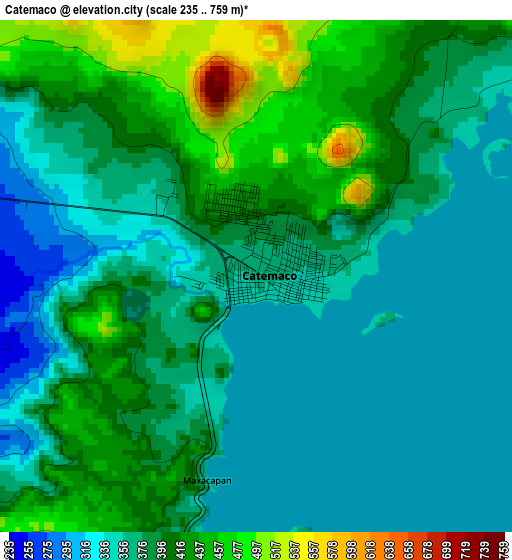
Below is the Elevation map of Catemaco, which displays elevation range with different colors. Scale of the first map is from 235 to 759 m (771 to 2490 ft) with average elevation of 384.9 meters (=1263 ft) [note 1]
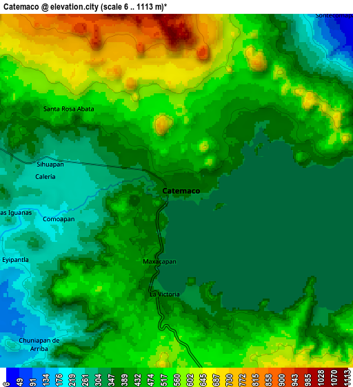
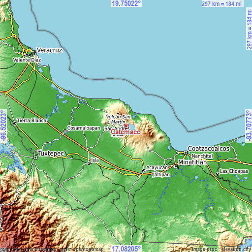
These maps also provides idea of topography and contour of this city, they are displayed at different zoom levels. More info about maps, scale and edge coordinates you can find below images.
| \ | Map #1 | Map #2 | Topo.Map |
| Scale [m] | 235..759 m | 6..1113 m | × |
| Scale [ft] | 771..2490 ft | 20..3652 ft | × |
| Average | 384.9 m = 1263 ft | 428.5 m = 1406 ft | × |
| Width | 9.27 km = 5.8 mi | 18.54 km = 11.5 mi | 296.7 km = 184.4 mi |
| Height | 9.27 km = 5.8 mi | 18.54 km = 11.5 mi | 296.7 km = 184.4 mi |
| ↑Max Latitude | 18.462998° | 18.504677° | 19.75022° |
| Latitude at center | 18.42131° | 18.42131° | 18.42131° |
| ↓Min Latitude | 18.379611° | 18.337903° | 17.08205° |
| ← Min Longitude | -95.157925° | -95.201871° | -96.52023° |
| Longitude center | -95.11398° | -95.11398° | -95.11398° |
| →Max Longitude | -95.070035° | -95.026089° | -93.70773° |
Nearby cities:
Cities around Catemaco sort by population:
• Comoapan elevation 212 m
6.5 km,  255°
255°
• El Salto de Eyipantla 197 m
10 km,  249°
249°
• Calería 244 m
6.7 km,  277°
277°
• Sihuapan 257 m
7 km, 284°
• Chuniapan de Arriba 175 m
10.8 km,  221°
221°
• Cerro las Iguanas 252 m
9.1 km, 262°
• La Victoria 342 m
5.2 km,  189°
189°
• Zapoapan de Cabañas 526 m
9.9 km,  169°
169°
• Matacapan 260 m
5.7 km,  285°
285°
• Santa Rosa Abata 521 m
7.2 km,  308°
308°
• Laguneta 471 m
9.6 km,  204°
204°
• El Huidero 264 m
7.8 km,  241°
241°
Multilingual:
 En español:
Catemaco elevación 363 m.
 En France:
Catemaco élévation 363 m.
 Auf Deutsch:
Catemaco höhe über dem Meeresspiegel ist 363 m.

Sources and notes:
- [note 1] Map square and city borders are not equal. Map elevation data is calculated only from area inside that square.
- [src 1] Elevation data from geonames database provided with same terms of usage.
- [src 2] The elevation map of Catemaco is generated using elevation data from NASA's 3 arcsec (90m) resolution SRTM data.
- [src 3] Base (background) map © OpenStreetMap contributors tiles are generated by Geofabrik and OpenTopoMap.
Copyright & License:
This Catemaco Elevation Map is licensed under CC BY-SA. You may reuse any part from this page, if you give a proper credit by linking to this URL:
 More info on terms of use page.