Chahuite elevation
Chahuite (Oaxaca, Chahuites), Mexico elevation is 25 meters and Chahuite elevation in feet is 82 ft above sea level [src 1]. Chahuite is a populated place (feature code) with elevation that is 1289 meters (4229 ft) smaller than average city elevation in Mexico.
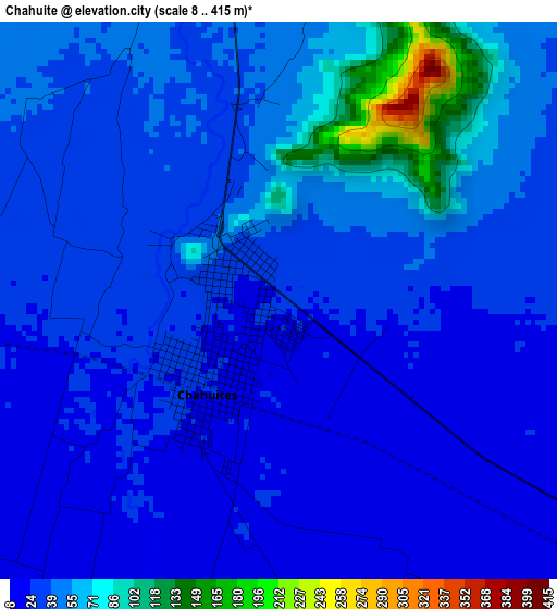
Below is the Elevation map of Chahuite, which displays elevation range with different colors. Scale of the first map is from 8 to 415 m (26 to 1362 ft) with average elevation of 39.9 meters (=131 ft) [note 1]
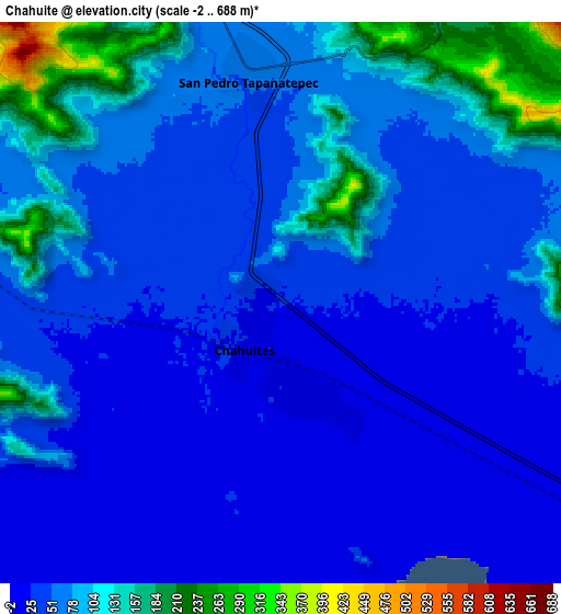
These maps also provides idea of topography and contour of this city, they are displayed at different zoom levels. More info about maps, scale and edge coordinates you can find below images.
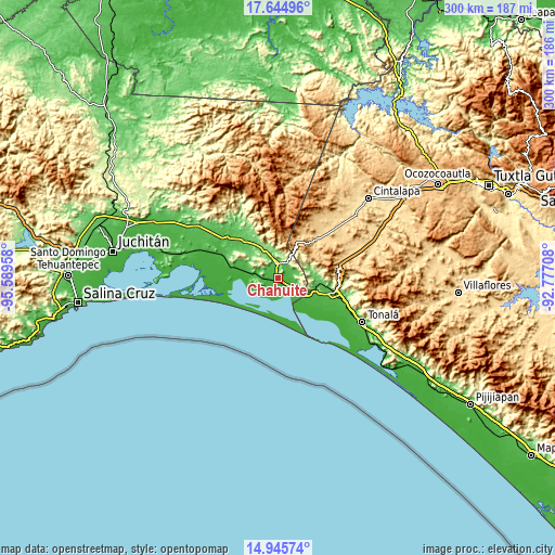
| \ | Map #1 | Map #2 | Topo.Map |
| Scale [m] | 8..415 m | -2..688 m | × |
| Scale [ft] | 26..1362 ft | -7..2257 ft | × |
| Average | 39.9 m = 131 ft | 63.3 m = 208 ft | × |
| Width | 9.38 km = 5.8 mi | 18.76 km = 11.7 mi | 300.1 km = 186.5 mi |
| Height | 9.38 km = 5.8 mi | 18.76 km = 11.7 mi | 300.1 km = 186.5 mi |
| ↑Max Latitude | 16.342174° | 16.38434° | 17.64496° |
| Latitude at center | 16.3° | 16.3° | 16.3° |
| ↓Min Latitude | 16.257817° | 16.215624° | 14.94574° |
| ← Min Longitude | -94.227275° | -94.271221° | -95.58958° |
| Longitude center | -94.18333° | -94.18333° | -94.18333° |
| →Max Longitude | -94.139385° | -94.095439° | -92.77708° |
Nearby cities:
Cities around Chahuite sort by population:
• Chahuites elevation 25 m
1.8 km,  223°
223°
• El Espinal 234 m
11.4 km,  47°
47°
• San Pedro Tapanatepec 57 m
8 km,  352°
352°
• Santo Domingo Zanatepec 70 m
26.9 km,  319°
319°
• Emiliano Zapata 14 m
18.9 km,  138°
138°
• Azteca 37 m
27 km,  109°
109°
• La Gloria 2 m
19.5 km,  153°
153°
• Nueva Tenochtitlán (Rizo de Oro) 795 m
22.5 km,  29°
29°
• La Línea 4 m
24.5 km, 140°
• Lázaro Cárdenas 77 m
22 km,  93°
93°
• Los Corazones 16 m
15.4 km,  130°
130°
• General Pascual Fentes 108 m
17.2 km,  330°
330°
Multilingual:
 En español:
Chahuite elevación 25 m.
 En France:
Chahuite élévation 25 m.


Sources and notes:
- [note 1] Map square and city borders are not equal. Map elevation data is calculated only from area inside that square.
- [src 1] Elevation data from geonames database provided with same terms of usage.
- [src 2] The elevation map of Chahuite is generated using elevation data from NASA's 3 arcsec (90m) resolution SRTM data.
- [src 3] Base (background) map © OpenStreetMap contributors tiles are generated by Geofabrik and OpenTopoMap.
Copyright & License:
This Chahuite Elevation Map is licensed under CC BY-SA. You may reuse any part from this page, if you give a proper credit by linking to this URL:
 More info on terms of use page.