Chapantongo elevation
Chapantongo (Hidalgo), Mexico elevation is 2125 meters and Chapantongo elevation in feet is 6972 ft above sea level [src 1]. Chapantongo is a populated place (feature code) with elevation that is 811 meters (2661 ft) bigger than average city elevation in Mexico.
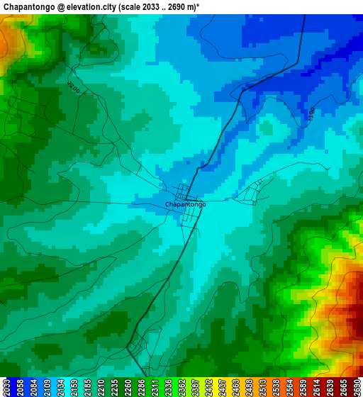
Below is the Elevation map of Chapantongo, which displays elevation range with different colors. Scale of the first map is from 2033 to 2690 m (6670 to 8825 ft) with average elevation of 2202.7 meters (=7227 ft) [note 1]
These maps also provides idea of topography and contour of this city, they are displayed at different zoom levels. More info about maps, scale and edge coordinates you can find below images.
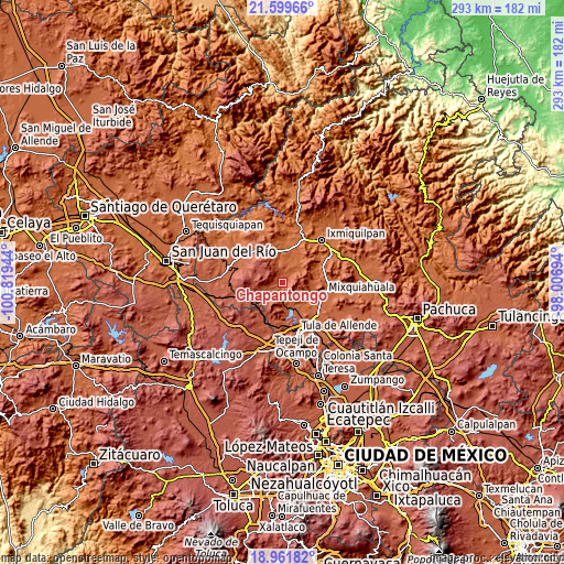
| \ | Map #1 | Topo.Map |
| Scale [m] | 2033..2690 m | × |
| Scale [ft] | 6670..8825 ft | × |
| Average | 2202.7 m = 7227 ft | × |
| Width | 9.17 km = 5.7 mi | 293.3 km = 182.2 mi |
| Height | 9.17 km = 5.7 mi | 293.3 km = 182.2 mi |
| ↑Max Latitude | 20.327564° | 21.59966° |
| Latitude at center | 20.28635° | 20.28635° |
| ↓Min Latitude | 20.245125° | 18.96182° |
| ← Min Longitude | -99.457135° | -100.81944° |
| Longitude center | -99.41319° | -99.41319° |
| →Max Longitude | -99.369245° | -98.00694° |
Nearby cities:
Cities around Chapantongo sort by population:
• Atengo elevation 2034 m
15.3 km,  143°
143°
• San Gabriel 2032 m
15.1 km,  147°
147°
• San Juan Achichilco 2025 m
15.8 km, 139°
• Santa Maria Amealco 2384 m
15.2 km,  249°
249°
• Santiago Acayutlán 1986 m
15.8 km,  128°
128°
• Tepeitic 2046 m
13.7 km,  111°
111°
• Alfajayucan 1880 m
15.1 km,  26°
26°
• San Bartolo Ozocalpan 2263 m
10.6 km,  228°
228°
• Tenango 2041 m
14.4 km,  117°
117°
• La Loma 2033 m
13.5 km,  164°
164°
• Pino Suárez 2200 m
4.6 km,  190°
190°
• José María Pino Suárez 2193 m
4.4 km, 190°
Multilingual:
 En español:
Chapantongo elevación 2125 m.
 En France:
Chapantongo élévation 2125 m.
 Auf Deutsch:
Chapantongo höhe über dem Meeresspiegel ist 2125 m.

Sources and notes:
- [note 1] Map square and city borders are not equal. Map elevation data is calculated only from area inside that square.
- [src 1] Elevation data from geonames database provided with same terms of usage.
- [src 2] The elevation map of Chapantongo is generated using elevation data from NASA's 3 arcsec (90m) resolution SRTM data.
- [src 3] Base (background) map © OpenStreetMap contributors tiles are generated by Geofabrik and OpenTopoMap.
Copyright & License:
This Chapantongo Elevation Map is licensed under CC BY-SA. You may reuse any part from this page, if you give a proper credit by linking to this URL:
 More info on terms of use page.