Chicoasén elevation
Chicoasén (Chiapas), Mexico elevation is 239 meters and Chicoasén elevation in feet is 784 ft above sea level [src 1]. Chicoasén is a seat of a second-order administrative division (feature code) with elevation that is 1075 meters (3527 ft) smaller than average city elevation in Mexico.
Below is the Elevation map of Chicoasén, which displays elevation range with different colors. Scale of the first map is from 192 to 1648 m (630 to 5407 ft) with average elevation of 640.9 meters (=2103 ft) [note 1]
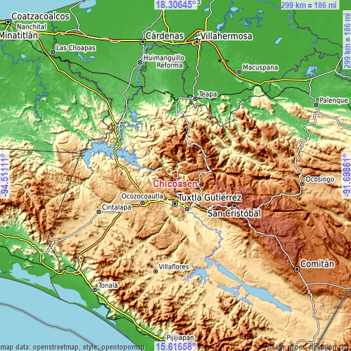
These maps also provides idea of topography and contour of this city, they are displayed at different zoom levels. More info about maps, scale and edge coordinates you can find below images.
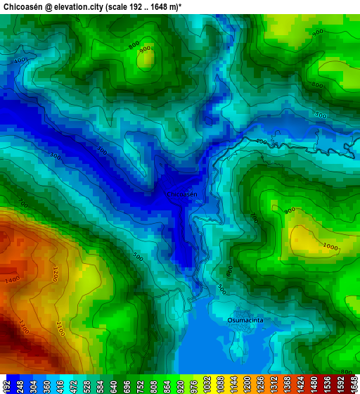
| \ | Map #1 | Topo.Map |
| Scale [m] | 192..1648 m | × |
| Scale [ft] | 630..5407 ft | × |
| Average | 640.9 m = 2103 ft | × |
| Width | 9.35 km = 5.8 mi | 299.1 km = 185.9 mi |
| Height | 9.35 km = 5.8 mi | 299.1 km = 185.9 mi |
| ↑Max Latitude | 17.008358° | 18.30645° |
| Latitude at center | 16.96633° | 16.96633° |
| ↓Min Latitude | 16.924293° | 15.61658° |
| ← Min Longitude | -93.148805° | -94.51111° |
| Longitude center | -93.10486° | -93.10486° |
| →Max Longitude | -93.060915° | -91.69861° |
Nearby cities:
Cities around Chicoasén sort by population:
• San Fernando elevation 880 m
15.2 km,  226°
226°
• Francisco Sarabia 865 m
10 km,  103°
103°
• El Progreso 921 m
16 km, 231°
• El Copalar 871 m
15.3 km, 229°
• Osumacinta 404 m
3.7 km,  155°
155°
• Francisco I. Madero 868 m
15.7 km, 229°
• Gabriel Esquinca 1180 m
8 km,  249°
249°
• Benito Juárez 969 m
12.9 km,  224°
224°
• El Palmar (San Gabriel) 1348 m
16.4 km,  144°
144°
• Venustiano Carranza 1323 m
13.2 km,  126°
126°
• Buenavista (Matasanos) 1421 m
16.2 km,  14°
14°
• Luis Espinoza 1442 m
11 km,  48°
48°
Multilingual:
 En español:
Chicoasén elevación 239 m.
 En France:
Chicoasén élévation 239 m.
 Auf Deutsch:
Chicoasén höhe über dem Meeresspiegel ist 239 m.

Sources and notes:
- [note 1] Map square and city borders are not equal. Map elevation data is calculated only from area inside that square.
- [src 1] Elevation data from geonames database provided with same terms of usage.
- [src 2] The elevation map of Chicoasén is generated using elevation data from NASA's 3 arcsec (90m) resolution SRTM data.
- [src 3] Base (background) map © OpenStreetMap contributors tiles are generated by Geofabrik and OpenTopoMap.
Copyright & License:
This Chicoasén Elevation Map is licensed under CC BY-SA. You may reuse any part from this page, if you give a proper credit by linking to this URL:
 More info on terms of use page.