Chiquihuitlán de Benito Juárez elevation
Chiquihuitlán de Benito Juárez (Oaxaca), Mexico elevation is 1211 meters and Chiquihuitlán de Benito Juárez elevation in feet is 3973 ft above sea level [src 1]. Chiquihuitlán de Benito Juárez is a seat of a second-order administrative division (feature code) with elevation that is 103 meters (338 ft) smaller than average city elevation in Mexico.
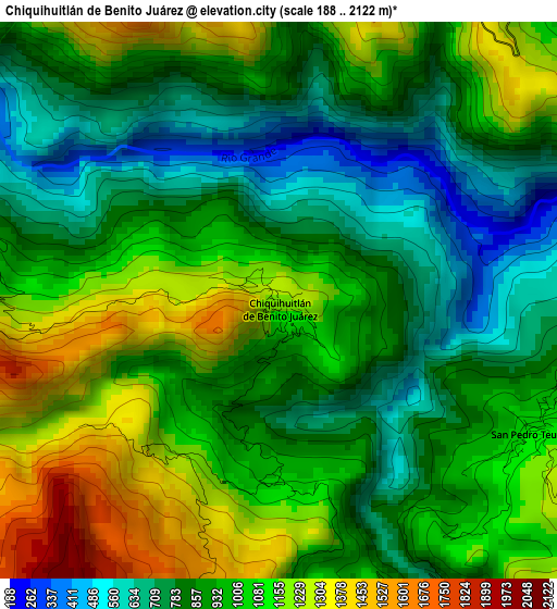
Below is the Elevation map of Chiquihuitlán de Benito Juárez, which displays elevation range with different colors. Scale of the first map is from 188 to 2122 m (617 to 6962 ft) with average elevation of 957.7 meters (=3142 ft) [note 1]
These maps also provides idea of topography and contour of this city, they are displayed at different zoom levels. More info about maps, scale and edge coordinates you can find below images.
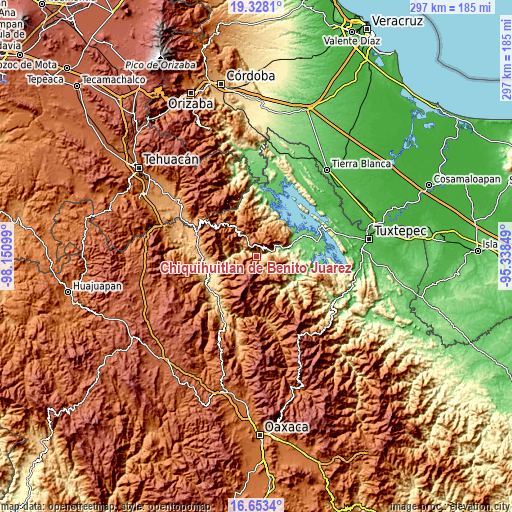
| \ | Map #1 | Topo.Map |
| Scale [m] | 188..2122 m | × |
| Scale [ft] | 617..6962 ft | × |
| Average | 957.7 m = 3142 ft | × |
| Width | 9.29 km = 5.8 mi | 297.4 km = 184.8 mi |
| Height | 9.29 km = 5.8 mi | 297.4 km = 184.8 mi |
| ↑Max Latitude | 18.037611° | 19.3281° |
| Latitude at center | 17.99582° | 17.99582° |
| ↓Min Latitude | 17.95402° | 16.6534° |
| ← Min Longitude | -96.788685° | -98.15099° |
| Longitude center | -96.74474° | -96.74474° |
| →Max Longitude | -96.700795° | -95.33849° |
Nearby cities:
Cities around Chiquihuitlán de Benito Juárez sort by population:
• San Bartolomé Ayautla elevation 682 m
8.8 km,  62°
62°
• San Andrés Hidalgo 1833 m
17 km,  337°
337°
• Santa María la Asunción 1652 m
14.7 km,  327°
327°
• Huautepec 1717 m
12.9 km, 335°
• San Andrés Teotilalpam 1527 m
10.5 km,  116°
116°
• Xochitonalco 1660 m
15.5 km,  314°
314°
• San Juan Sautla 1050 m
17 km,  154°
154°
• San Juan Coatzospam 1871 m
6.3 km, 342°
• Llano de Agua 1644 m
14.1 km, 330°
• San José Tenango 762 m
17.5 km,  9°
9°
• Loma Chapultepec 1711 m
17 km,  324°
324°
• San Pedro Teutila 1044 m
4.6 km, 116°
Multilingual:
 En español:
San Juan Chiquihuitlán elevación 1211 m.
 En France:
Chiquihuitlán de Benito Juárez élévation 1211 m.
 Auf Deutsch:
Chiquihuitlán de Benito Juárez höhe über dem Meeresspiegel ist 1211 m.
 На русском:
Chiquihuitlán de Benito Juárez высота над уровнем моря 1211 м
Sources and notes:
- [note 1] Map square and city borders are not equal. Map elevation data is calculated only from area inside that square.
- [src 1] Elevation data from geonames database provided with same terms of usage.
- [src 2] The elevation map of Chiquihuitlán de Benito Juárez is generated using elevation data from NASA's 3 arcsec (90m) resolution SRTM data.
- [src 3] Base (background) map © OpenStreetMap contributors tiles are generated by Geofabrik and OpenTopoMap.
Copyright & License:
This Chiquihuitlán de Benito Juárez Elevation Map is licensed under CC BY-SA. You may reuse any part from this page, if you give a proper credit by linking to this URL:
 More info on terms of use page.