Ciudad Mendoza elevation
Ciudad Mendoza (Veracruz, Camerino Z. Mendoza), Mexico elevation is 1333 meters and Ciudad Mendoza elevation in feet is 4373 ft above sea level [src 1]. Ciudad Mendoza is a seat of a second-order administrative division (feature code) with elevation that is 19 meters (62 ft) bigger than average city elevation in Mexico.
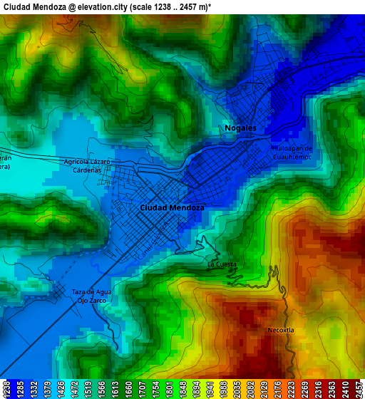
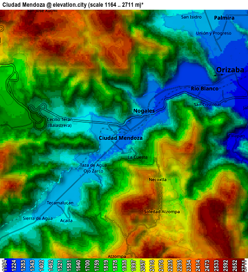
Below is the Elevation map of Ciudad Mendoza, which displays elevation range with different colors. Scale of the first map is from 1238 to 2457 m (4062 to 8061 ft) with average elevation of 1643.4 meters (=5392 ft) [note 1]
These maps also provides idea of topography and contour of this city, they are displayed at different zoom levels. More info about maps, scale and edge coordinates you can find below images.
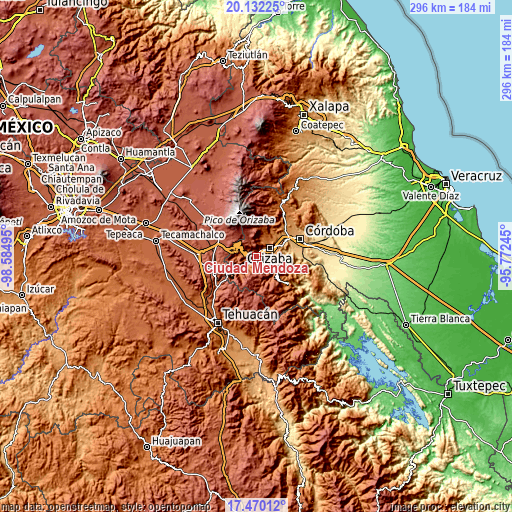
| \ | Map #1 | Map #2 | Topo.Map |
| Scale [m] | 1238..2457 m | 1164..2711 m | × |
| Scale [ft] | 4062..8061 ft | 3819..8894 ft | × |
| Average | 1643.4 m = 5392 ft | 1825.3 m = 5989 ft | × |
| Width | 9.25 km = 5.7 mi | 18.5 km = 11.5 mi | 296 km = 183.9 mi |
| Height | 9.25 km = 5.7 mi | 18.5 km = 11.5 mi | 296 km = 183.9 mi |
| ↑Max Latitude | 18.848044° | 18.889628° | 20.13225° |
| Latitude at center | 18.80645° | 18.80645° | 18.80645° |
| ↓Min Latitude | 18.764846° | 18.723231° | 17.47012° |
| ← Min Longitude | -97.222645° | -97.266591° | -98.58495° |
| Longitude center | -97.1787° | -97.1787° | -97.1787° |
| →Max Longitude | -97.134755° | -97.090809° | -95.77245° |
Nearby cities:
Cities around Ciudad Mendoza sort by population:
• Río Blanco elevation 1278 m
3.6 km,  41°
41°
• Nogales 1308 m
2.9 km,  34°
34°
• Huiloapan de Cuauhtémoc 1289 m
2.8 km,  64°
64°
• Agrícola Lázaro Cárdenas 1385 m
2.2 km,  291°
291°
• Necoxtla 2047 m
4.1 km,  139°
139°
• Tecamalucan 1380 m
7 km,  224°
224°
• La Cuesta 1666 m
2.1 km,  148°
148°
• Cecilio Terán 1486 m
5 km,  280°
280°
• San Cristóbal 1237 m
6.3 km,  65°
65°
• Taza de Agua Ojo Zarco 1342 m
3.6 km, 223°
• Acatla 1439 m
7.6 km,  213°
213°
• Soledad Atzompa 2108 m
6.5 km, 152°
Multilingual:
 En español:
Ciudad Mendoza elevación 1333 m.
 En France:
Ciudad Mendoza élévation 1333 m.
 Auf Deutsch:
Ciudad Mendoza höhe über dem Meeresspiegel ist 1333 m.

Sources and notes:
- [note 1] Map square and city borders are not equal. Map elevation data is calculated only from area inside that square.
- [src 1] Elevation data from geonames database provided with same terms of usage.
- [src 2] The elevation map of Ciudad Mendoza is generated using elevation data from NASA's 3 arcsec (90m) resolution SRTM data.
- [src 3] Base (background) map © OpenStreetMap contributors tiles are generated by Geofabrik and OpenTopoMap.
Copyright & License:
This Ciudad Mendoza Elevation Map is licensed under CC BY-SA. You may reuse any part from this page, if you give a proper credit by linking to this URL:
 More info on terms of use page.