Corral Nuevo elevation
Corral Nuevo (Veracruz, Acayucan), Mexico elevation is 67 meters and Corral Nuevo elevation in feet is 220 ft above sea level [src 1]. Corral Nuevo is a populated place (feature code) with elevation that is 1247 meters (4091 ft) smaller than average city elevation in Mexico.
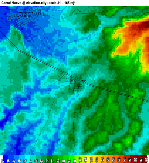
Below is the Elevation map of Corral Nuevo, which displays elevation range with different colors. Scale of the first map is from 31 to 165 m (102 to 541 ft) with average elevation of 65.3 meters (=214 ft) [note 1]
These maps also provides idea of topography and contour of this city, they are displayed at different zoom levels. More info about maps, scale and edge coordinates you can find below images.
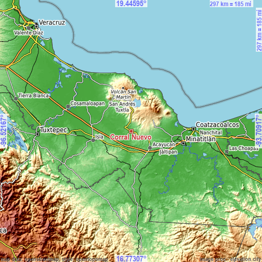
| \ | Map #1 | Topo.Map |
| Scale [m] | 31..165 m | × |
| Scale [ft] | 102..541 ft | × |
| Average | 65.3 m = 214 ft | × |
| Width | 9.29 km = 5.8 mi | 297.2 km = 184.7 mi |
| Height | 9.29 km = 5.8 mi | 297.2 km = 184.7 mi |
| ↑Max Latitude | 18.156372° | 19.44595° |
| Latitude at center | 18.11461° | 18.11461° |
| ↓Min Latitude | 18.072838° | 16.77307° |
| ← Min Longitude | -95.159365° | -96.52167° |
| Longitude center | -95.11542° | -95.11542° |
| →Max Longitude | -95.071475° | -93.70917° |
Nearby cities:
Cities around Corral Nuevo sort by population:
• Juan Díaz Covarrubias elevation 38 m
9 km,  303°
303°
• Hueyapan de Ocampo 44 m
4.9 km,  313°
313°
• Los Mangos 350 m
14.4 km,  357°
357°
• El Aguacate 450 m
17.9 km,  58°
58°
• Santa Rosa Loma Larga 375 m
13.3 km,  13°
13°
• Quiamoloapan 173 m
13.9 km,  114°
114°
• Santa Catalina 33 m
11.2 km, 299°
• Sabaneta 332 m
12.6 km,  16°
16°
• Tierra Nueva 355 m
14.3 km,  43°
43°
• El Blanco 41 m
18 km,  255°
255°
• Zapoapan de Amapan 50 m
15.5 km,  331°
331°
• Campo de Águila 185 m
14.6 km, 110°
Multilingual:
 En español:
Corral Nuevo elevación 67 m.
 En France:
Corral Nuevo élévation 67 m.
 Auf Deutsch:
Corral Nuevo höhe über dem Meeresspiegel ist 67 m.

Sources and notes:
- [note 1] Map square and city borders are not equal. Map elevation data is calculated only from area inside that square.
- [src 1] Elevation data from geonames database provided with same terms of usage.
- [src 2] The elevation map of Corral Nuevo is generated using elevation data from NASA's 3 arcsec (90m) resolution SRTM data.
- [src 3] Base (background) map © OpenStreetMap contributors tiles are generated by Geofabrik and OpenTopoMap.
Copyright & License:
This Corral Nuevo Elevation Map is licensed under CC BY-SA. You may reuse any part from this page, if you give a proper credit by linking to this URL:
 More info on terms of use page.