Ciudad Mante elevation
Ciudad Mante (Tamaulipas, El Mante), Mexico elevation is 86 meters and Ciudad Mante elevation in feet is 282 ft above sea level [src 1]. Ciudad Mante is a seat of a second-order administrative division (feature code) with elevation that is 1228 meters (4029 ft) smaller than average city elevation in Mexico.
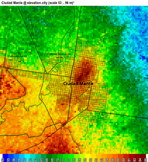
Below is the Elevation map of Ciudad Mante, which displays elevation range with different colors. Scale of the first map is from 53 to 96 m (174 to 315 ft) with average elevation of 75.1 meters (=246 ft) [note 1]
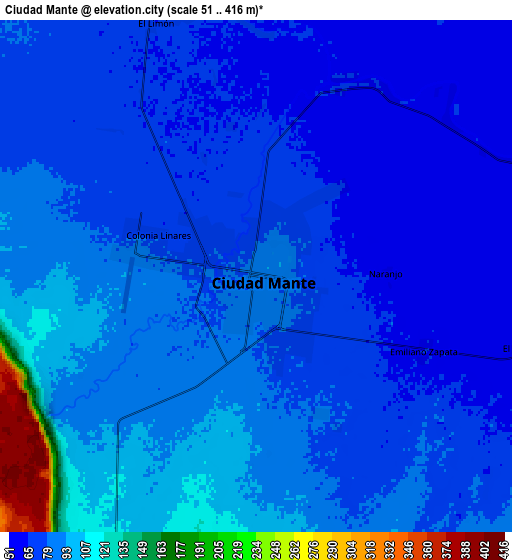
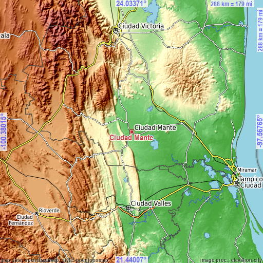
These maps also provides idea of topography and contour of this city, they are displayed at different zoom levels. More info about maps, scale and edge coordinates you can find below images.
| \ | Map #1 | Map #2 | Topo.Map |
| Scale [m] | 53..96 m | 51..416 m | × |
| Scale [ft] | 174..315 ft | 167..1365 ft | × |
| Average | 75.1 m = 246 ft | 84.2 m = 276 ft | × |
| Width | 9.01 km = 5.6 mi | 18.03 km = 11.2 mi | 288.4 km = 179.2 mi |
| Height | 9.01 km = 5.6 mi | 18.03 km = 11.2 mi | 288.4 km = 179.2 mi |
| ↑Max Latitude | 22.783562° | 22.824073° | 24.03371° |
| Latitude at center | 22.74304° | 22.74304° | 22.74304° |
| ↓Min Latitude | 22.702506° | 22.661959° | 21.44007° |
| ← Min Longitude | -99.017845° | -99.061791° | -100.38015° |
| Longitude center | -98.9739° | -98.9739° | -98.9739° |
| →Max Longitude | -98.929955° | -98.886009° | -97.56765° |
Nearby cities:
Cities around Ciudad Mante sort by population:
• El Naranjo elevation 281 m
43.8 km,  236°
236°
• Xicoténcatl 95 m
28.3 km,  6°
6°
• Ocampo 355 m
39.1 km,  287°
287°
• Graciano Sánchez 40 m
44.1 km,  102°
102°
• Antiguo Morelos 204 m
24.2 km,  207°
207°
• El Limón 69 m
9.7 km,  340°
340°
• Primero de Mayo 90 m
24.3 km, 5°
• El Abra 128 m
14.5 km,  199°
199°
• Nuevo Morelos 284 m
34.1 km,  227°
227°
• Quintero 118 m
10.9 km,  215°
215°
• Plan de Ayala 69 m
31 km,  136°
136°
• Gómez Farías 80 m
16.5 km, 341°
Multilingual:
 En español:
Ciudad Mante elevación 86 m.
 En France:
Ciudad Mante élévation 86 m.
 Auf Deutsch:
Ciudad Mante höhe über dem Meeresspiegel ist 86 m.

Sources and notes:
- [note 1] Map square and city borders are not equal. Map elevation data is calculated only from area inside that square.
- [src 1] Elevation data from geonames database provided with same terms of usage.
- [src 2] The elevation map of Ciudad Mante is generated using elevation data from NASA's 3 arcsec (90m) resolution SRTM data.
- [src 3] Base (background) map © OpenStreetMap contributors tiles are generated by Geofabrik and OpenTopoMap.
Copyright & License:
This Ciudad Mante Elevation Map is licensed under CC BY-SA. You may reuse any part from this page, if you give a proper credit by linking to this URL:
 More info on terms of use page.