Huixquilucan de Degollado elevation
Huixquilucan de Degollado (State of Mexico, Huixquilucan), Mexico elevation is 2712 meters and Huixquilucan de Degollado elevation in feet is 8898 ft above sea level [src 1]. Huixquilucan de Degollado is a seat of a second-order administrative division (feature code) with elevation that is 1398 meters (4587 ft) bigger than average city elevation in Mexico.
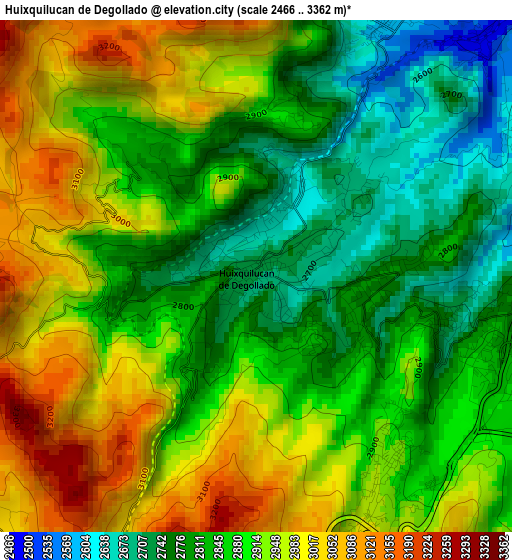
Below is the Elevation map of Huixquilucan de Degollado, which displays elevation range with different colors. Scale of the first map is from 2466 to 3362 m (8091 to 11030 ft) with average elevation of 2887.9 meters (=9475 ft) [note 1]
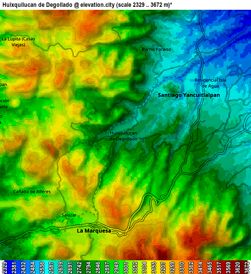
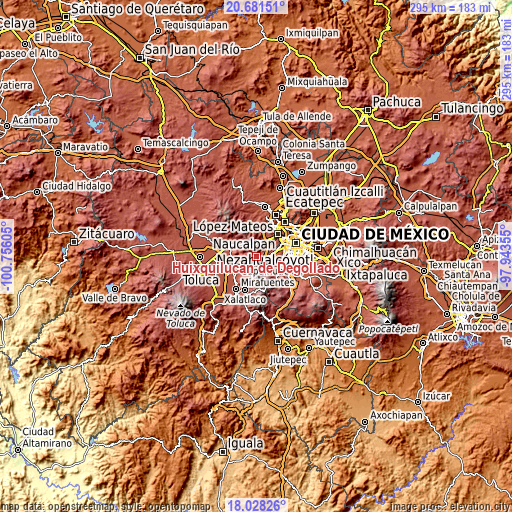
These maps also provides idea of topography and contour of this city, they are displayed at different zoom levels. More info about maps, scale and edge coordinates you can find below images.
| \ | Map #1 | Map #2 | Topo.Map |
| Scale [m] | 2466..3362 m | 2329..3672 m | × |
| Scale [ft] | 8091..11030 ft | 7641..12047 ft | × |
| Average | 2887.9 m = 9475 ft | 2929.7 m = 9612 ft | × |
| Width | 9.22 km = 5.7 mi | 18.44 km = 11.5 mi | 295 km = 183.3 mi |
| Height | 9.22 km = 5.7 mi | 18.44 km = 11.5 mi | 295 km = 183.3 mi |
| ↑Max Latitude | 19.401735° | 19.44318° | 20.68151° |
| Latitude at center | 19.36028° | 19.36028° | 19.36028° |
| ↓Min Latitude | 19.318814° | 19.277338° | 18.02826° |
| ← Min Longitude | -99.393745° | -99.437691° | -100.75605° |
| Longitude center | -99.3498° | -99.3498° | -99.3498° |
| →Max Longitude | -99.305855° | -99.261909° | -97.94355° |
Nearby cities:
Cities around Huixquilucan de Degollado sort by population:
• Huixquilucan elevation 2712 m
0.1 km,  218°
218°
• Zacamulpa 2773 m
2 km,  104°
104°
• San Juan Yautepec 2822 m
1.6 km,  142°
142°
• Dos Ríos 2644 m
1.7 km,  22°
22°
• San Francisco Ayotuzco 2687 m
1 km,  309°
309°
• Ignacio Allende 2828 m
2.2 km,  214°
214°
• San Jacinto 2756 m
2.8 km,  84°
84°
• El Cerrito 2734 m
0.6 km,  164°
164°
• Cerro de San Francisco 2707 m
1.1 km,  350°
350°
• Paraje la Pera 2700 m
2.3 km,  12°
12°
• El Palacio 2728 m
1.2 km, 216°
• Barrio de San Ramón 2711 m
2.5 km,  52°
52°
Multilingual:
 En español:
Huixquilucan elevación 2712 m.
 En France:
Huixquilucan de Degollado élévation 2712 m.
 Auf Deutsch:
Huixquilucan de Degollado höhe über dem Meeresspiegel ist 2712 m.
 На русском:
Huixquilucan de Degollado высота над уровнем моря 2712 м
Sources and notes:
- [note 1] Map square and city borders are not equal. Map elevation data is calculated only from area inside that square.
- [src 1] Elevation data from geonames database provided with same terms of usage.
- [src 2] The elevation map of Huixquilucan de Degollado is generated using elevation data from NASA's 3 arcsec (90m) resolution SRTM data.
- [src 3] Base (background) map © OpenStreetMap contributors tiles are generated by Geofabrik and OpenTopoMap.
Copyright & License:
This Huixquilucan de Degollado Elevation Map is licensed under CC BY-SA. You may reuse any part from this page, if you give a proper credit by linking to this URL:
 More info on terms of use page.